

15 Use of TIR from Space in Operational Systems
255
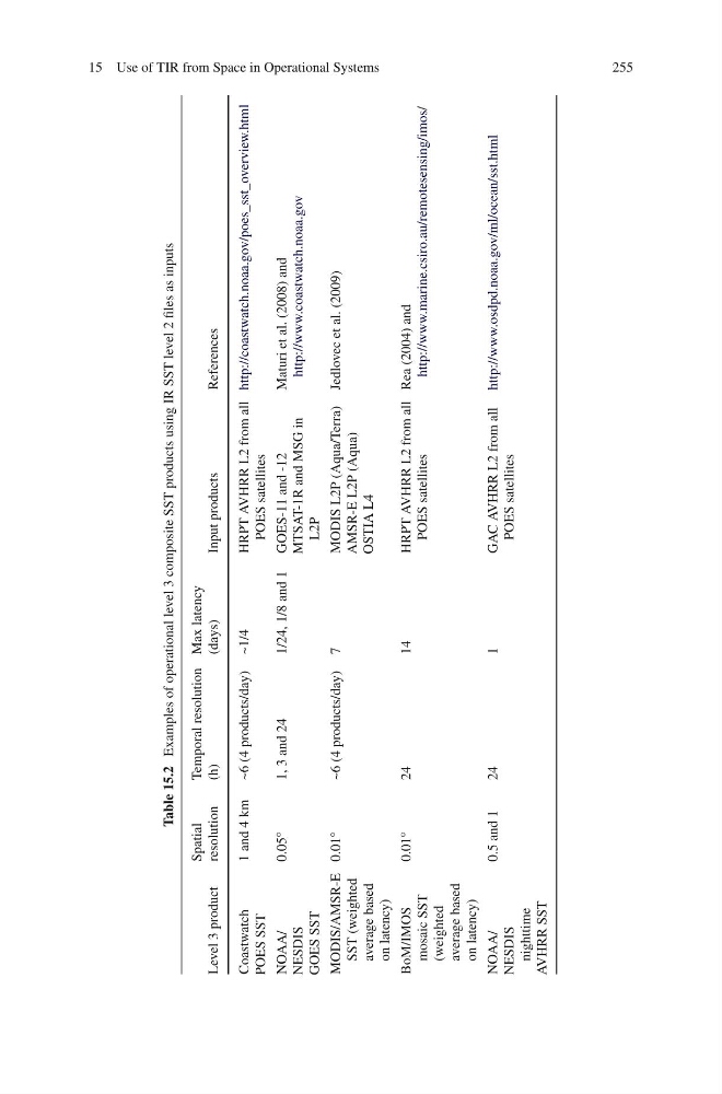
Table 15.2
Examples of operational level 3 composite SST products using IR SST level 2 files as inputs
Level 3 product
Spatial
resolution
Temporal resolution
(h)
Max latency
(days)
Input products
References
Coastwatch
POES SST
1 and 4 km ~6 (4 products/day) ~1/4
HRPT AVHRR L2 from all
POES satellites
http://coastwatch.noaa.gov/poes_sst_overview.html
NOAA/
NESDIS
GOES SST
0.05 ◦
1, 3 and 24
1/24, 1/8 and 1 GOES-11 and -12
MTSAT-1R and MSG in
L2P
Maturi et al. (2008) and
http://www.coastwatch.noaa.gov
MODIS/AMSR-E
SST (weighted
average based
on latency)
0.01 ◦
~6 (4 products/day) 7
MODIS L2P (Aqua/Terra)
AMSR-E L2P (Aqua)
OSTIA L4
Jedlovec et al. (2009)
BoM/IMOS
mosaic SST
(weighted
average based
on latency)
0.01 ◦
24
14
HRPT AVHRR L2 from all
POES satellites
Rea (2004) and
http://www.marine.csiro.au/remotesensing/imos/
NOAA/
NESDIS
nighttime
AVHRR SST
0.5 and 1
24
1
GAC AVHRR L2 from all
POES satellites
http://www.osdpd.noaa.gov/ml/ocean/sst.html
255
Table 15.2
Examples of operational level 3 composite SST products using IR SST level 2 files as inputs
Level 3 product
Spatial
resolution
Temporal resolution
(h)
Max latency
(days)
Input products
References
Coastwatch
POES SST
1 and 4 km ~6 (4 products/day) ~1/4
HRPT AVHRR L2 from all
POES satellites
http://coastwatch.noaa.gov/poes_sst_overview.html
NOAA/
NESDIS
GOES SST
0.05 ◦
1, 3 and 24
1/24, 1/8 and 1 GOES-11 and -12
MTSAT-1R and MSG in
L2P
Maturi et al. (2008) and
http://www.coastwatch.noaa.gov
MODIS/AMSR-E
SST (weighted
average based
on latency)
0.01 ◦
~6 (4 products/day) 7
MODIS L2P (Aqua/Terra)
AMSR-E L2P (Aqua)
OSTIA L4
Jedlovec et al. (2009)
BoM/IMOS
mosaic SST
(weighted
average based
on latency)
0.01 ◦
24
14
HRPT AVHRR L2 from all
POES satellites
Rea (2004) and
http://www.marine.csiro.au/remotesensing/imos/
NOAA/
NESDIS
nighttime
AVHRR SST
0.5 and 1
24
1
GAC AVHRR L2 from all
POES satellites
http://www.osdpd.noaa.gov/ml/ocean/sst.html