

10 Absolute Dynamic Topography from Altimetry
175
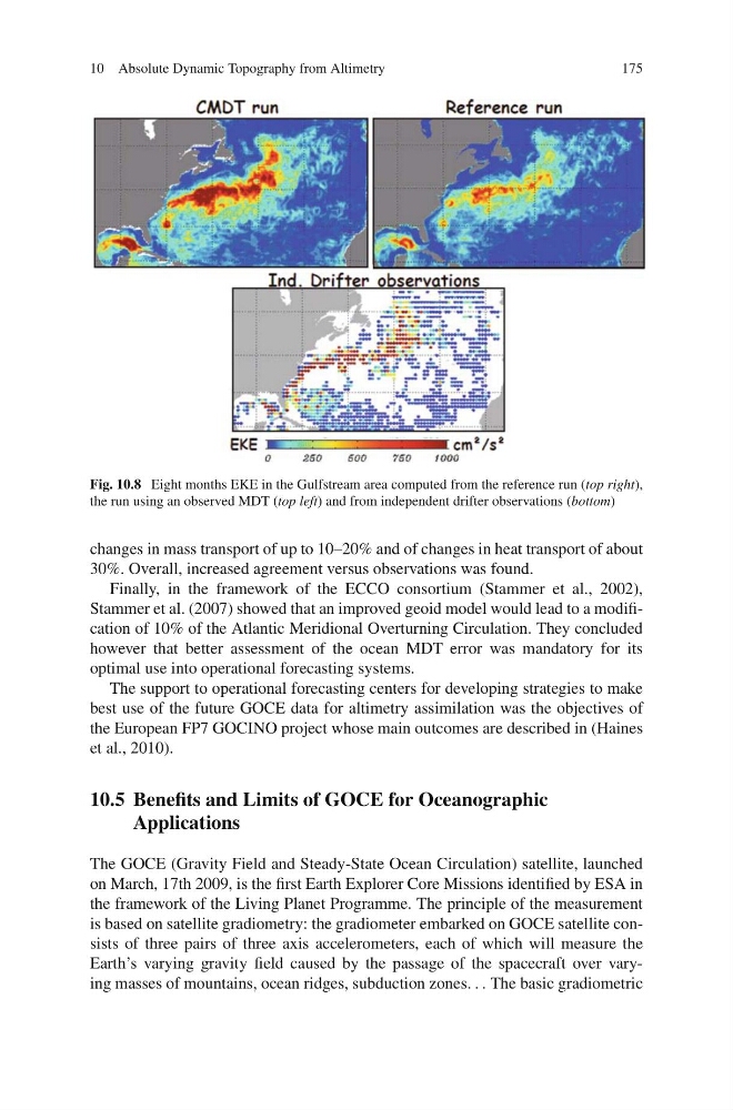
Fig. 10.8 Eight months EKE in the Gulfstream area computed from the reference run (top right),
the run using an observed MDT (top left) and from independent drifter observations (bottom)
changes in mass transport of up to 10–20% and of changes in heat transport of about
30%. Overall, increased agreement versus observations was found.
Finally, in the framework of the ECCO consortium (Stammer et al., 2002),
Stammer et al. (2007) showed that an improved geoid model would lead to a modification of 10% of the Atlantic Meridional Overturning Circulation. They concluded
however that better assessment of the ocean MDT error was mandatory for its
optimal use into operational forecasting systems.
The support to operational forecasting centers for developing strategies to make
best use of the future GOCE data for altimetry assimilation was the objectives of
the European FP7 GOCINO project whose main outcomes are described in (Haines
et al., 2010).
10.5 Benefits and Limits of GOCE for Oceanographic
Applications
The GOCE (Gravity Field and Steady-State Ocean Circulation) satellite, launched
on March, 17th 2009, is the first Earth Explorer Core Missions identified by ESA in
the framework of the Living Planet Programme. The principle of the measurement
is based on satellite gradiometry: the gradiometer embarked on GOCE satellite consists of three pairs of three axis accelerometers, each of which will measure the
Earth’s varying gravity field caused by the passage of the spacecraft over varying masses of mountains, ocean ridges, subduction zones. . . The basic gradiometric
175
Fig. 10.8 Eight months EKE in the Gulfstream area computed from the reference run (top right),
the run using an observed MDT (top left) and from independent drifter observations (bottom)
changes in mass transport of up to 10–20% and of changes in heat transport of about
30%. Overall, increased agreement versus observations was found.
Finally, in the framework of the ECCO consortium (Stammer et al., 2002),
Stammer et al. (2007) showed that an improved geoid model would lead to a modification of 10% of the Atlantic Meridional Overturning Circulation. They concluded
however that better assessment of the ocean MDT error was mandatory for its
optimal use into operational forecasting systems.
The support to operational forecasting centers for developing strategies to make
best use of the future GOCE data for altimetry assimilation was the objectives of
the European FP7 GOCINO project whose main outcomes are described in (Haines
et al., 2010).
10.5 Benefits and Limits of GOCE for Oceanographic
Applications
The GOCE (Gravity Field and Steady-State Ocean Circulation) satellite, launched
on March, 17th 2009, is the first Earth Explorer Core Missions identified by ESA in
the framework of the Living Planet Programme. The principle of the measurement
is based on satellite gradiometry: the gradiometer embarked on GOCE satellite consists of three pairs of three axis accelerometers, each of which will measure the
Earth’s varying gravity field caused by the passage of the spacecraft over varying masses of mountains, ocean ridges, subduction zones. . . The basic gradiometric