

5 Direct Surface Current Field Imaging from Space
87
Runoff Data Centre (GRDC) in Koblenz, Germany. However, in some regions measurements are practically impossible for various reasons, and many countries do
not publish existing runoff data. The development of a satellite-based monitoring
system is highly desirable (Alsdorf et al., 2003).
British scientists have already demonstrated the monitoring of water levels in
rivers on the basis of reprocessed conventional radar altimeter data (Berry, 2002).
Concepts for more specific high-resolution altimeter missions for river applications
has been proposed to ESA and NASA. The use of stationary microwave Doppler
scatterometers for current measurements in rivers has been demonstrated by Plant
et al. (2005).
Results of current retrievals in the Elbe river by SRTM and TerraSAR-X ATI
have been discussed in Section 5.1. Scientists at the University of Hamburg are
currently studying concepts for a data synthesis system for optimal river runoff
assessments on the basis of spaceborne ATI and altimeter data, other available data,
and numerical model computations.
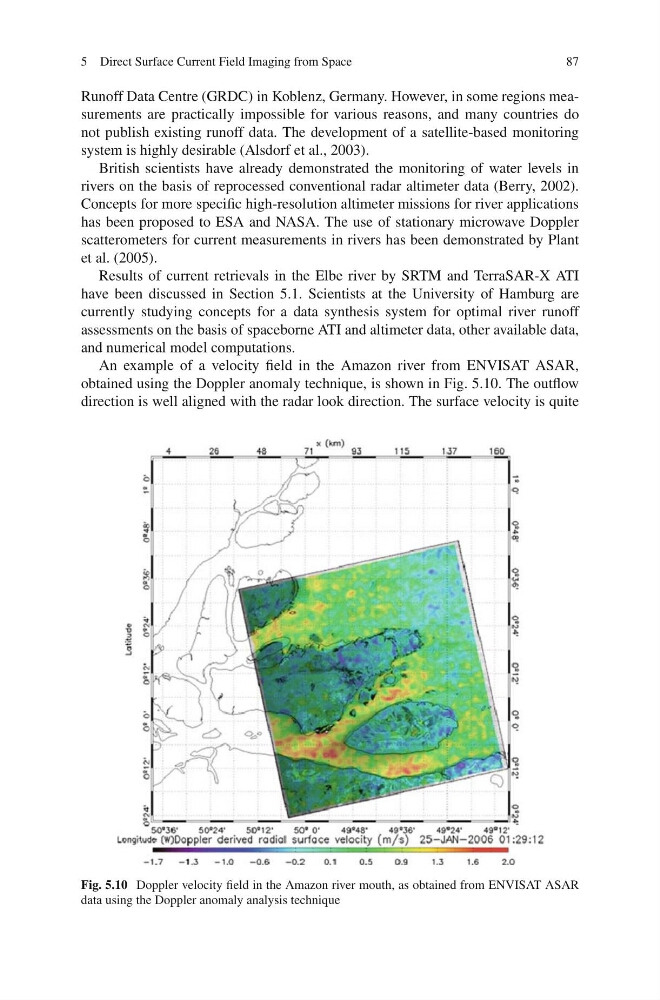
An example of a velocity field in the Amazon river from ENVISAT ASAR,
obtained using the Doppler anomaly technique, is shown in Fig. 5.10. The outflow
direction is well aligned with the radar look direction. The surface velocity is quite
Fig. 5.10 Doppler velocity field in the Amazon river mouth, as obtained from ENVISAT ASAR
data using the Doppler anomaly analysis technique
87
Runoff Data Centre (GRDC) in Koblenz, Germany. However, in some regions measurements are practically impossible for various reasons, and many countries do
not publish existing runoff data. The development of a satellite-based monitoring
system is highly desirable (Alsdorf et al., 2003).
British scientists have already demonstrated the monitoring of water levels in
rivers on the basis of reprocessed conventional radar altimeter data (Berry, 2002).
Concepts for more specific high-resolution altimeter missions for river applications
has been proposed to ESA and NASA. The use of stationary microwave Doppler
scatterometers for current measurements in rivers has been demonstrated by Plant
et al. (2005).
Results of current retrievals in the Elbe river by SRTM and TerraSAR-X ATI
have been discussed in Section 5.1. Scientists at the University of Hamburg are
currently studying concepts for a data synthesis system for optimal river runoff
assessments on the basis of spaceborne ATI and altimeter data, other available data,
and numerical model computations.
An example of a velocity field in the Amazon river from ENVISAT ASAR,
obtained using the Doppler anomaly technique, is shown in Fig. 5.10. The outflow
direction is well aligned with the radar look direction. The surface velocity is quite
Fig. 5.10 Doppler velocity field in the Amazon river mouth, as obtained from ENVISAT ASAR
data using the Doppler anomaly analysis technique