

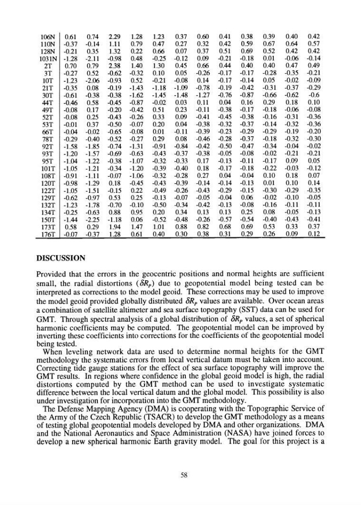
106N 0.61
0.74
2.29
1.28
1.23
0.37
0.60
0.41
0.38
0.39
0.40
0.42
110N -0.37 -0.14 1.11
0.79
0.47
0.27
0.32
0.42
0.59
0.67
0.64
0.57
128N -0.21
0.35
1.32
0.22
0.66
0.07
0.37
0.51
0.69
0.52
0.42
0.42
1031N -1.28 -2.11 -0.98 0.48
-0.25 -0.12 0.09 -0.21 -0.18 0.01
-0.06 -0.14
2T
0.70
0.79
2.38
1.40
1.30
0.45
0.66
0.44
0.40
0.40
0.47
0.49
3T
-0.27 0.52 -0.62 -0.32 0.10
0.05 -0.26 -0.17 -0.17 -0.28 -0.35 -0.21
lOT
-1.23 -2.06 -0.93 0.52 -0.21 -0.08 0.14 -0.17 -0.14 0.05
-0.02 -0.09
21T
-0.35 0.08 -0.19 -1.43 -1.18 -1.09 -0.78 -0.19 -0.42 -0.31 -0.37 -0.29
30T
-0.61 -0.38 -0.38 -1.62 -1.45 -1.48 -1.27 -0.76 -0.87 -0.66 -0.62
-0.6
44T
-0.46 0.58 -0.45 -0.87 -0.02 0.03
0.11
0.04
0.16
0.29
0.18
0.10
49T
-0.08 0.17 -0.20 -0.42 0.51
0.23 -0.11 -0.38 -0.17 -0.18 -0.06 -0.08
52T
-0.08 0.25 -0.43 -0.26 0.33
0.09 -0.41 -0.45 -0.38 -0.16 -0.31 -0.36
53T
-0.01
0.37 -0.50 -0.07 0.20
0.04 -0.38 -0.32 -0.37 -0.14 -0.32 -0.36
66T
-0.04 -0.02 -0.65 -0.08 om -0.11 -0.39 -0.23 -0.29 -0.29 -0.19 -0.20
78T
-0.29 -0.40 -0.52 -0.27 0.29
0.08 -0.46 -0.28 -0.37 -0.18 -0.32 -0.30
92T
-1.58 -1.85 -0.74 -1.31 -0.91 -0.84 -0.42 -0.50 -0.47 -0.34 -0.04 -0.02
93T
-1.20 -1.57 -0.69 -0.63 -0.43 -0.37 -0.38 -0.05 -0.08 -0.02 -0.21 -0.21
95T
-1.04 -1.22 -0.38 -1.07 -0.32 -0.33 0.17 -O.l3 -0.11 -0.17 0.09
0.05
10 IT -1.05 -1.21 -0.34 -1.20 -0.39 -0.40 0.18 -0.17 -0.18 -0.22 -0.03 -0.12
108T -0.91 -1.11 -0.07 -1.06 -0.32 -0.28 0.27
0.04 -0.04 0.10
0.18
0.07
120T -0.98 -1.29 0.18 -0.45 -0.43 -0.39 -0.14 -0.14 -0.13
om 0.10 0.14
122T -1.05 -1.51 -0.15 0.22
-0.49 -0.26 -0.43 -0.29 -0.15 -0.30 -0.29 -0.35
129T -0.62 -0.97 0.53
0.25
-0.l3 -0.07 -0.05 -0.04 0.06
-0.02 -0.10 -0.05
l32T -1.23 -1.78 -0.70 -0.10 -0.50 -0.34 -0.42 -0.l3 -0.08 -0.16 -0.11 -0.11
l34T -0.25 -0.63 0.88
0.95
0.20
0.34
0.l3
0.l3
0.25
0.08
-0.05 -0.13
150T -1.44 -2.25 -1.18 0.06 -0.52 -0.48 -0.26 -0.57 -0.54 -0.40 ~0.43 -0.41
173T 0.58
0.29
1.94
1.47
1.01
0.88
0.82
0.68
0.69
0.53
0.33
0.37
176T -0.07 -0.37
1.28
0.61
0.40
0.30- 0.38
0.31
0.29
0.26
0.09
0.12
DISCUSSION
Provided that the errors in the geocentric positions and normal heights are sufficient
small, the radial distortions (8Rp) due to geopotential model being tested can be
interpreted as corrections to the model geoid. These corrections may be used to improve
the model geoid provided globally distributed 8Rp values are available. Over ocean areas
a combination of satellite altimeter and sea surface topography (SST) data can be used for
GMT. Through spectral analysis of a global distribution of 8Rp values, a set of spherical
harmonic coefficients may be computed. The geopotential model can be improved by
inverting these coefficients into corrections for the coefficients of the geopotential model
being tested.
When leveling network data are used to determine normal heights for the GMT
methodology the systematic errors from local vertical datum must be taken into account.
Correcting tide gauge stations for the effect of sea surface topography will improve the
GMT results. In regions where confidence in the global geoid model is high, the radial
distortions computed by the GMT method can be used to investigate systematic
difference between the local vertical datum and the global model. Th:is possibility is also
under investigation for incorporation into the GMT methodology.
The Defense Mapping Agency (DMA) is cooperating with the Topographic Service of
the Army of the Czech Republic (TSACR) to develop the GMT methodology as a means
of testing global geopotential models developed by DMA and other organizations. DMA
and the National Aeronautics and Space Administration (NASA) have joined forces to
develop a new spherical harmonic Earth gravity model. The goal for this project is a
58
0.74
2.29
1.28
1.23
0.37
0.60
0.41
0.38
0.39
0.40
0.42
110N -0.37 -0.14 1.11
0.79
0.47
0.27
0.32
0.42
0.59
0.67
0.64
0.57
128N -0.21
0.35
1.32
0.22
0.66
0.07
0.37
0.51
0.69
0.52
0.42
0.42
1031N -1.28 -2.11 -0.98 0.48
-0.25 -0.12 0.09 -0.21 -0.18 0.01
-0.06 -0.14
2T
0.70
0.79
2.38
1.40
1.30
0.45
0.66
0.44
0.40
0.40
0.47
0.49
3T
-0.27 0.52 -0.62 -0.32 0.10
0.05 -0.26 -0.17 -0.17 -0.28 -0.35 -0.21
lOT
-1.23 -2.06 -0.93 0.52 -0.21 -0.08 0.14 -0.17 -0.14 0.05
-0.02 -0.09
21T
-0.35 0.08 -0.19 -1.43 -1.18 -1.09 -0.78 -0.19 -0.42 -0.31 -0.37 -0.29
30T
-0.61 -0.38 -0.38 -1.62 -1.45 -1.48 -1.27 -0.76 -0.87 -0.66 -0.62
-0.6
44T
-0.46 0.58 -0.45 -0.87 -0.02 0.03
0.11
0.04
0.16
0.29
0.18
0.10
49T
-0.08 0.17 -0.20 -0.42 0.51
0.23 -0.11 -0.38 -0.17 -0.18 -0.06 -0.08
52T
-0.08 0.25 -0.43 -0.26 0.33
0.09 -0.41 -0.45 -0.38 -0.16 -0.31 -0.36
53T
-0.01
0.37 -0.50 -0.07 0.20
0.04 -0.38 -0.32 -0.37 -0.14 -0.32 -0.36
66T
-0.04 -0.02 -0.65 -0.08 om -0.11 -0.39 -0.23 -0.29 -0.29 -0.19 -0.20
78T
-0.29 -0.40 -0.52 -0.27 0.29
0.08 -0.46 -0.28 -0.37 -0.18 -0.32 -0.30
92T
-1.58 -1.85 -0.74 -1.31 -0.91 -0.84 -0.42 -0.50 -0.47 -0.34 -0.04 -0.02
93T
-1.20 -1.57 -0.69 -0.63 -0.43 -0.37 -0.38 -0.05 -0.08 -0.02 -0.21 -0.21
95T
-1.04 -1.22 -0.38 -1.07 -0.32 -0.33 0.17 -O.l3 -0.11 -0.17 0.09
0.05
10 IT -1.05 -1.21 -0.34 -1.20 -0.39 -0.40 0.18 -0.17 -0.18 -0.22 -0.03 -0.12
108T -0.91 -1.11 -0.07 -1.06 -0.32 -0.28 0.27
0.04 -0.04 0.10
0.18
0.07
120T -0.98 -1.29 0.18 -0.45 -0.43 -0.39 -0.14 -0.14 -0.13
om 0.10 0.14
122T -1.05 -1.51 -0.15 0.22
-0.49 -0.26 -0.43 -0.29 -0.15 -0.30 -0.29 -0.35
129T -0.62 -0.97 0.53
0.25
-0.l3 -0.07 -0.05 -0.04 0.06
-0.02 -0.10 -0.05
l32T -1.23 -1.78 -0.70 -0.10 -0.50 -0.34 -0.42 -0.l3 -0.08 -0.16 -0.11 -0.11
l34T -0.25 -0.63 0.88
0.95
0.20
0.34
0.l3
0.l3
0.25
0.08
-0.05 -0.13
150T -1.44 -2.25 -1.18 0.06 -0.52 -0.48 -0.26 -0.57 -0.54 -0.40 ~0.43 -0.41
173T 0.58
0.29
1.94
1.47
1.01
0.88
0.82
0.68
0.69
0.53
0.33
0.37
176T -0.07 -0.37
1.28
0.61
0.40
0.30- 0.38
0.31
0.29
0.26
0.09
0.12
DISCUSSION
Provided that the errors in the geocentric positions and normal heights are sufficient
small, the radial distortions (8Rp) due to geopotential model being tested can be
interpreted as corrections to the model geoid. These corrections may be used to improve
the model geoid provided globally distributed 8Rp values are available. Over ocean areas
a combination of satellite altimeter and sea surface topography (SST) data can be used for
GMT. Through spectral analysis of a global distribution of 8Rp values, a set of spherical
harmonic coefficients may be computed. The geopotential model can be improved by
inverting these coefficients into corrections for the coefficients of the geopotential model
being tested.
When leveling network data are used to determine normal heights for the GMT
methodology the systematic errors from local vertical datum must be taken into account.
Correcting tide gauge stations for the effect of sea surface topography will improve the
GMT results. In regions where confidence in the global geoid model is high, the radial
distortions computed by the GMT method can be used to investigate systematic
difference between the local vertical datum and the global model. Th:is possibility is also
under investigation for incorporation into the GMT methodology.
The Defense Mapping Agency (DMA) is cooperating with the Topographic Service of
the Army of the Czech Republic (TSACR) to develop the GMT methodology as a means
of testing global geopotential models developed by DMA and other organizations. DMA
and the National Aeronautics and Space Administration (NASA) have joined forces to
develop a new spherical harmonic Earth gravity model. The goal for this project is a
58