

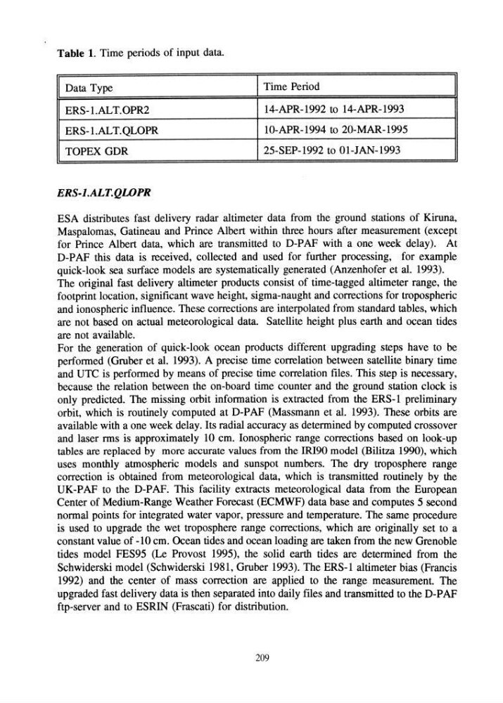
Table 1. Time periods of input data.
I Data Type
I Time Period
I
ERS-l.AL T.OPR2
14-APR-1992 to 14-APR-I993
ERS-1.ALT.QLOPR
1O-APR-1994 to 20-MAR-1995
TOPEX GDR
25-SEP-1992 to 01-JAN-1993
ERS-l.ALT.QWPR
ESA distributes fast delivery radar altimeter data from the ground stations of Kiruna,
Maspalomas, Gatineau and Prince Albert within three hours after measurement (except
for Prince Albert data, which are transmitted to D-PAF with a one week delay). At
D-PAF this data is received, collected and used for further processing, for example
quick-look sea surface models are systematically generated (Anzenhofer et al. 1993).
The original fast delivery altimeter products consist of time-tagged altimeter range, the
footprint location, significant wave height, sigma-naught and corrections for tropospheric
and ionospheric influence. These corrections are interpolated from standard tables, which
are not based on actual meteorological data. Satellite height plus earth and ocean tides
are not available.
For the generation of quick-look ocean products different upgrading steps have to be
performed (Gruber et al. 1993). A precise time correlation between satellite binary time
and UTC is performed by means of precise time correlation files. This step is necessary,
because the relation between the on-board time counter and the ground station clock is
only predicted. The missing orbit information is extracted from the ERS-l preliminary
orbit, which is routinely computed at D-PAF (Massmann et al. 1993). These orbits are
available with a one week delay. Its radial accuracy as determined by computed crossover
and laser rms is approximately 10 cm. Ionospheric range corrections based on look-up
tables are replaced by more accurate values from the IRI90 model (Bilitza 1990), which
uses monthly atmospheric models and sunspot numbers. The dry troposphere range
correction is obtained from meteorological data, which is transmitted routinely by the
UK-PAF to the D-PAF. This facility extracts meteorological data from the European
Center of Medium-Range Weather Forecast (ECMWF) data base and computes 5 second
normal points for integrated water vapor, pressure and temperature. The same procedure
is used to upgrade the wet troposphere range corrections, which are originally set to a
constant value of -10 cm. Ocean tides and ocean loading are taken from the new Grenoble
tides model FES95 (Le Provost 1995), the solid earth tides are determined from the
Schwiderski model (Schwiderski 1981, Gruber 1993). The ERS-l altimeter bias (Francis
1992) and the center of mass correction are applied to the range measurement. The
upgraded fast delivery data is then separated into daily files and transmitted to the D-PAF
ftp-server and to ESRIN (Frascati) for distribution.
209
I Data Type
I Time Period
I
ERS-l.AL T.OPR2
14-APR-1992 to 14-APR-I993
ERS-1.ALT.QLOPR
1O-APR-1994 to 20-MAR-1995
TOPEX GDR
25-SEP-1992 to 01-JAN-1993
ERS-l.ALT.QWPR
ESA distributes fast delivery radar altimeter data from the ground stations of Kiruna,
Maspalomas, Gatineau and Prince Albert within three hours after measurement (except
for Prince Albert data, which are transmitted to D-PAF with a one week delay). At
D-PAF this data is received, collected and used for further processing, for example
quick-look sea surface models are systematically generated (Anzenhofer et al. 1993).
The original fast delivery altimeter products consist of time-tagged altimeter range, the
footprint location, significant wave height, sigma-naught and corrections for tropospheric
and ionospheric influence. These corrections are interpolated from standard tables, which
are not based on actual meteorological data. Satellite height plus earth and ocean tides
are not available.
For the generation of quick-look ocean products different upgrading steps have to be
performed (Gruber et al. 1993). A precise time correlation between satellite binary time
and UTC is performed by means of precise time correlation files. This step is necessary,
because the relation between the on-board time counter and the ground station clock is
only predicted. The missing orbit information is extracted from the ERS-l preliminary
orbit, which is routinely computed at D-PAF (Massmann et al. 1993). These orbits are
available with a one week delay. Its radial accuracy as determined by computed crossover
and laser rms is approximately 10 cm. Ionospheric range corrections based on look-up
tables are replaced by more accurate values from the IRI90 model (Bilitza 1990), which
uses monthly atmospheric models and sunspot numbers. The dry troposphere range
correction is obtained from meteorological data, which is transmitted routinely by the
UK-PAF to the D-PAF. This facility extracts meteorological data from the European
Center of Medium-Range Weather Forecast (ECMWF) data base and computes 5 second
normal points for integrated water vapor, pressure and temperature. The same procedure
is used to upgrade the wet troposphere range corrections, which are originally set to a
constant value of -10 cm. Ocean tides and ocean loading are taken from the new Grenoble
tides model FES95 (Le Provost 1995), the solid earth tides are determined from the
Schwiderski model (Schwiderski 1981, Gruber 1993). The ERS-l altimeter bias (Francis
1992) and the center of mass correction are applied to the range measurement. The
upgraded fast delivery data is then separated into daily files and transmitted to the D-PAF
ftp-server and to ESRIN (Frascati) for distribution.
209