

of magnitude as late Pleistocene deglaciation (Trupin, 1993 ; James and Ivins, 1995 ;
Mitrovica and Peltier, 1993). Thus measuring accurately these secular variations is of
crucial interest for decorrelating the various potential contributions and constraining
models of mantle rheology.
At the seasonal time scale, in particular at the annual frequency" published studies
(Nerem et aI., 1993, Gegout and Cazenave, 1993) agree upon that the observed variations
of the zonal harmonics can be explained by air mass redistribution (Chao and Au, 1991),
with possible minor contributions from glaciers, continental waters and ocean mass
redistribution.
In this paper, we present a new determination of the secular variations of J 2 , J 3 and J 4 ,
as well as of the seasonal fluctuations of J 2 , based on precise orbit an.alyses of Lageos 1
and Lageos 2 over the time span 1984-1994.
LASER DATA ANALYSIS
The Lageos 1 and 2 satellites have been launched respectively in May 1976 and
October 1992 to measure Earth rotation parameters and tectonic plate motions as well as
to study slowly varying gravitational phenomena such as the temporal variations of the
Earth's gravity field due to changes of the inertia tensor.
Lageos 1 and 2 are passive laser satellites orbiting at an altitude of about 6000 km.
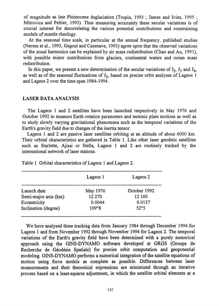
Their orbital characteristics are gathered in Table 1. Like other laser geodetic satellites
such as Starlette, Ajisai or Stella, Lageos 1 and 2 are routinely tracked by the
international network of laser stations.
Table 1. Orbital characteristics of Lageos 1 and Lageos 2.
Lageos 1
Lageos 2
Launch date
May 1976
October 1992
Semi-major axis (km)
12270
12160
Eccentricity
0.0044
0.0137
Inclination (degree)
109°8
52°5
We have analysed these tracking data from January 1984 through December 1994 for
Lageos 1 and from November 1992 through November 1994 for Lageos 2. The temporal
variations of the Earth's gravity field have been determined with a purely numerical
approach using the GINS-DYNAMO software developed at GRGS (Groupe de
Recherche de Geodesie Spatial e) for precise orbit computation and geopotential
modeling. GINS-DYNAMO performs a numerical integration of the satellite equations of
motion using force models as complete as possible. Differences between laser
measurements and their theoretical expressions are minimized through an iterative
process based on a least-squares adjustment, in which the satellite orbital elements at a
142
Mitrovica and Peltier, 1993). Thus measuring accurately these secular variations is of
crucial interest for decorrelating the various potential contributions and constraining
models of mantle rheology.
At the seasonal time scale, in particular at the annual frequency" published studies
(Nerem et aI., 1993, Gegout and Cazenave, 1993) agree upon that the observed variations
of the zonal harmonics can be explained by air mass redistribution (Chao and Au, 1991),
with possible minor contributions from glaciers, continental waters and ocean mass
redistribution.
In this paper, we present a new determination of the secular variations of J 2 , J 3 and J 4 ,
as well as of the seasonal fluctuations of J 2 , based on precise orbit an.alyses of Lageos 1
and Lageos 2 over the time span 1984-1994.
LASER DATA ANALYSIS
The Lageos 1 and 2 satellites have been launched respectively in May 1976 and
October 1992 to measure Earth rotation parameters and tectonic plate motions as well as
to study slowly varying gravitational phenomena such as the temporal variations of the
Earth's gravity field due to changes of the inertia tensor.
Lageos 1 and 2 are passive laser satellites orbiting at an altitude of about 6000 km.
Their orbital characteristics are gathered in Table 1. Like other laser geodetic satellites
such as Starlette, Ajisai or Stella, Lageos 1 and 2 are routinely tracked by the
international network of laser stations.
Table 1. Orbital characteristics of Lageos 1 and Lageos 2.
Lageos 1
Lageos 2
Launch date
May 1976
October 1992
Semi-major axis (km)
12270
12160
Eccentricity
0.0044
0.0137
Inclination (degree)
109°8
52°5
We have analysed these tracking data from January 1984 through December 1994 for
Lageos 1 and from November 1992 through November 1994 for Lageos 2. The temporal
variations of the Earth's gravity field have been determined with a purely numerical
approach using the GINS-DYNAMO software developed at GRGS (Groupe de
Recherche de Geodesie Spatial e) for precise orbit computation and geopotential
modeling. GINS-DYNAMO performs a numerical integration of the satellite equations of
motion using force models as complete as possible. Differences between laser
measurements and their theoretical expressions are minimized through an iterative
process based on a least-squares adjustment, in which the satellite orbital elements at a
142