

reduced 5' Geosat values in preparation for the collocation solution (Rapp and Pavlis,
1990). After each 1 0 cell of four 30' mean gravity anomalies were computed with their
accuracies, the mean of the reduced Geosat altimetry was not restored to the predictions.
141,133 mean gravity anomalies were computed with this procedure. Additionally, 9,272
mean gravity anomalies were computed from smaller size gravity anomalies based on ERS1 Geodetic Mission altimetry and used to fill in gaps of the Geosat coverage, predominately
north of 72 0 latitude. The ERS-1 work was performed by P. Knudsen and O. Andersen of
KMS, Denmark. Finally, other gaps in coverage were provided by D. Sandwell, Scripps
Institution of Oceanography, La Jolla, CA, with 1,017 mean gravity anomalies, primarily
around Antarctica. Differences ofDMA's best shipboard gravimetry versus the 30' x 30'
altimeter anomalies had standard deviations on the order of ±2 mgal with systematic
differences below 0.5 mgal.
The Merged 30' x 30' Gravity Anomaly File
As discussed below, the computation of a degree 360 model requires 30' x 30' gravity
anomalies over the entire Earth in order to take advantage of computational shortcuts that
are not otherwise available. Therefore, the 30' x 30' terrestrial and altimeter anomalies
were merged into a single file, with gaps being filled using values from a
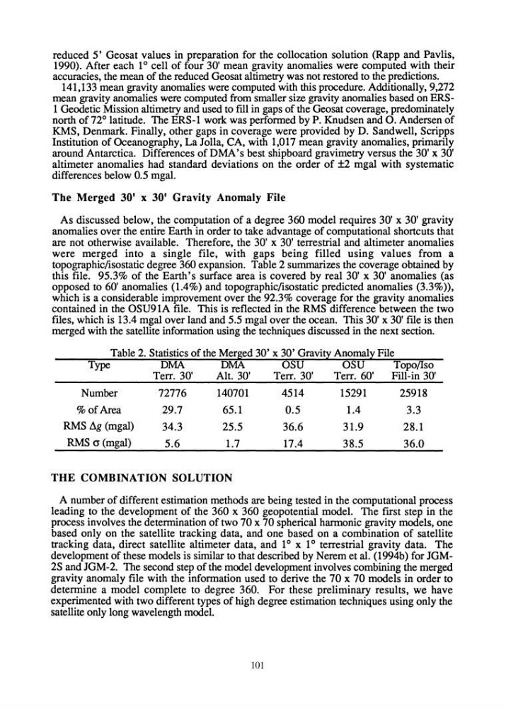
topographic/isostatic degree 360 expansion. Table 2 summarizes the coverage obtained by
this file. 95.3% of the Earth's surface area is covered by real 30' x 30' anomalies (as
opposed to 60' anomalies (1.4%) and topographic/isostatic predicted anomalies (3.3%»,
which is a considerable improvement over the 92.3% coverage for the gravity anomalies
contained in the OSU91A file. This is reflected in the RMS difference between the two
files, which is 13.4 mgal over land and 5.5 mgal over the ocean. This 30' x 30' file is then
merged with the satellite information using the techniques discussed in the next section.
Table 2. Statistics of the Merged 30' x 30' Gravity Anomaly File
Type
DMA
DMA
OSU
OSU
Topo/lso
Number
% of Area
RMS llg (mgal)
RMS (J (mgal)
Terr. 30'
Alt. 30'
Terr. 30'
Terr. 60'
Fill-in 30'
72776
140701
4514
15291
25918
29.7
65.1
0.5
1.4
3.3
34.3
25.5
36.6
31.9
28.1
5.6
1.7
17.4
38.5
36.0
THE COMBINATION SOLUTION
A number of different estimation methods are being tested in the computational process
leading to the development of the 360 x 360 geopotential model. The fIrst step in the
process involves the determination of two 70 x 70 spherical harmonic gravity models, one
based only on the satellite tracking data, and one based on a combination of satellite
tracking data, direct satellite altimeter data, and 1 ° x 1 ° terrestrial gravity data. The
development of these models is similar to that described by Nerem et al. (1994b) for JGM2S and JGM-2. The second step of the model development involves combining the merged
gravity anomaly file with the information used to derive the 70 x 70 models in order to
determine a model complete to degree 360. For these preliminary results, we have
experimented with two different types of high degree estimation techniques using only the
satellite only long wavelength model.
101
1990). After each 1 0 cell of four 30' mean gravity anomalies were computed with their
accuracies, the mean of the reduced Geosat altimetry was not restored to the predictions.
141,133 mean gravity anomalies were computed with this procedure. Additionally, 9,272
mean gravity anomalies were computed from smaller size gravity anomalies based on ERS1 Geodetic Mission altimetry and used to fill in gaps of the Geosat coverage, predominately
north of 72 0 latitude. The ERS-1 work was performed by P. Knudsen and O. Andersen of
KMS, Denmark. Finally, other gaps in coverage were provided by D. Sandwell, Scripps
Institution of Oceanography, La Jolla, CA, with 1,017 mean gravity anomalies, primarily
around Antarctica. Differences ofDMA's best shipboard gravimetry versus the 30' x 30'
altimeter anomalies had standard deviations on the order of ±2 mgal with systematic
differences below 0.5 mgal.
The Merged 30' x 30' Gravity Anomaly File
As discussed below, the computation of a degree 360 model requires 30' x 30' gravity
anomalies over the entire Earth in order to take advantage of computational shortcuts that
are not otherwise available. Therefore, the 30' x 30' terrestrial and altimeter anomalies
were merged into a single file, with gaps being filled using values from a
topographic/isostatic degree 360 expansion. Table 2 summarizes the coverage obtained by
this file. 95.3% of the Earth's surface area is covered by real 30' x 30' anomalies (as
opposed to 60' anomalies (1.4%) and topographic/isostatic predicted anomalies (3.3%»,
which is a considerable improvement over the 92.3% coverage for the gravity anomalies
contained in the OSU91A file. This is reflected in the RMS difference between the two
files, which is 13.4 mgal over land and 5.5 mgal over the ocean. This 30' x 30' file is then
merged with the satellite information using the techniques discussed in the next section.
Table 2. Statistics of the Merged 30' x 30' Gravity Anomaly File
Type
DMA
DMA
OSU
OSU
Topo/lso
Number
% of Area
RMS llg (mgal)
RMS (J (mgal)
Terr. 30'
Alt. 30'
Terr. 30'
Terr. 60'
Fill-in 30'
72776
140701
4514
15291
25918
29.7
65.1
0.5
1.4
3.3
34.3
25.5
36.6
31.9
28.1
5.6
1.7
17.4
38.5
36.0
THE COMBINATION SOLUTION
A number of different estimation methods are being tested in the computational process
leading to the development of the 360 x 360 geopotential model. The fIrst step in the
process involves the determination of two 70 x 70 spherical harmonic gravity models, one
based only on the satellite tracking data, and one based on a combination of satellite
tracking data, direct satellite altimeter data, and 1 ° x 1 ° terrestrial gravity data. The
development of these models is similar to that described by Nerem et al. (1994b) for JGM2S and JGM-2. The second step of the model development involves combining the merged
gravity anomaly file with the information used to derive the 70 x 70 models in order to
determine a model complete to degree 360. For these preliminary results, we have
experimented with two different types of high degree estimation techniques using only the
satellite only long wavelength model.
101