

perfonned. Weights for the individual data sets are detennined using an optimal weighting
strategy described by Lerch (1991). A subset of the SLR station coordinates are fixed,
while the rest of the station coordinates are estimated, thus the reference frame in which the
gravity model is computed is defmed by the SLR network, which for all practical purposes
is the same as the International Terrestrial Reference Frame (ITRF). This is strictly for the
purposes of accurately modeling the satellite tracking measurements. The gravity model
can be re-expressed in any desired reference frame, such as WGS-84, provided that the
transfonnation parameters between the reference frames are known.
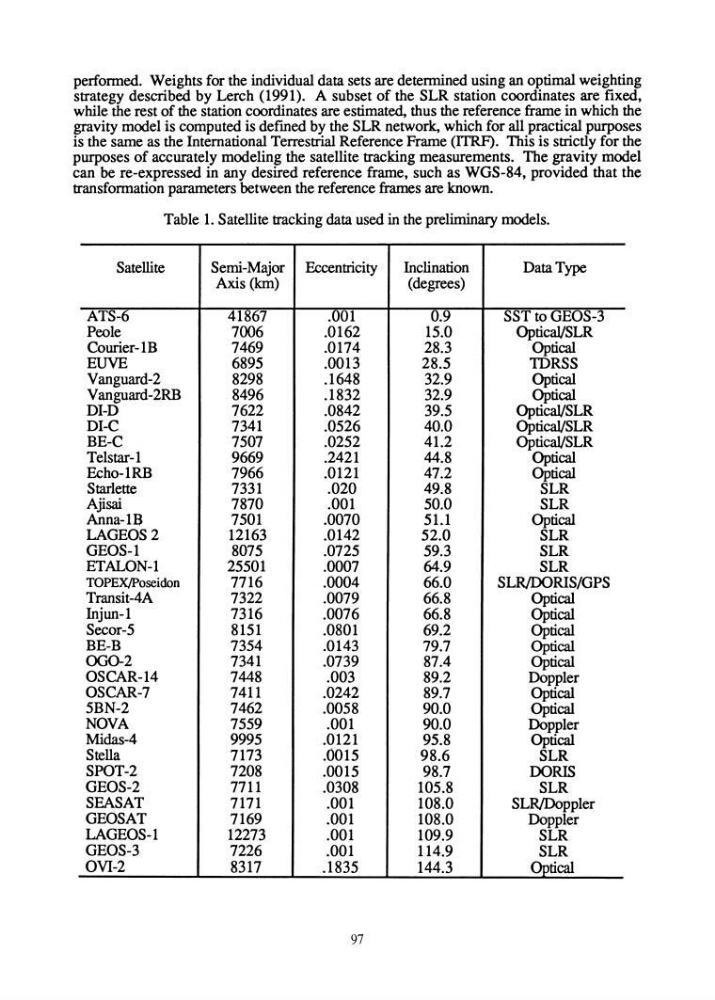
Table 1. Satellite tracking data used in the preliminary models.
Satellite
Semi-Major Eccentricity
Inclination
Data Type
Axis (kIn)
(degrees)
ATS-6
41867
.001
0.9
SST to GEOS-3
Peole
7006
.0162
15.0
OpticaVSLR
Courier-1B
7469
.0174
28.3
Optical
EUVE
6895
.0013
28.5
TDRSS
Vanguard-2
8298
.1648
32.9
Optical
Vanguard-2RB
8496
.1832
32.9
Optical
DI-D
7622
.0842
39.5
OpticaVSLR
DI-C
7341
.0526
40.0
OpticaVSLR
BE-C
7507
.0252
41.2
OpticaVSLR
Telstar-1
9669
.2421
44.8
Optical
Echo-1RB
7966
.0121
47.2
Optical
Starlette
7331
.020
49.8
SLR
Ajisai
7870
.001
50.0
SLR
Anna-1B
7501
.0070
51.1
Optical
LAGEOS2
12163
.0142
52.0
SLR
GEOS-1
8075
.0725
59.3
SLR
ETALON-1
25501
.0007
64.9
SLR
TOPEx/poseidon
7716
.0004
66.0
SLR/OORIS/GPS
Transit-4A
7322
.0079
66.8
Optical
Injun-1
7316
.0076
66.8
Optical
Secor-5
8151
.0801
69.2
Optical
BE-B
7354
.0143
79.7
Optical
000-2
7341
.0739
87.4
Optical
OSCAR-14
7448
.003
89.2
Doppler
OSCAR-7
7411
.0242
89.7
Optical
5BN-2
7462
.0058
90.0
Optical
NOVA
7559
.001
90.0
Doppler
Midas-4
9995
.0121
95.8
Optical
Stella
7173
.0015
98.6
SLR
SPOT-2
7208
.0015
98.7
DORIS
GEOS-2
7711
.0308
105.8
SLR
SEASAT
7171
.001
108.0
SLRIDoppler
GEOSAT
7169
.001
108.0
Doppler
LAGEOS-1
12273
.001
109.9
SLR
GEOS-3
7226
.001
114.9
SLR
OVJ-2
8317
.1835
144.3
. Optical
97
strategy described by Lerch (1991). A subset of the SLR station coordinates are fixed,
while the rest of the station coordinates are estimated, thus the reference frame in which the
gravity model is computed is defmed by the SLR network, which for all practical purposes
is the same as the International Terrestrial Reference Frame (ITRF). This is strictly for the
purposes of accurately modeling the satellite tracking measurements. The gravity model
can be re-expressed in any desired reference frame, such as WGS-84, provided that the
transfonnation parameters between the reference frames are known.
Table 1. Satellite tracking data used in the preliminary models.
Satellite
Semi-Major Eccentricity
Inclination
Data Type
Axis (kIn)
(degrees)
ATS-6
41867
.001
0.9
SST to GEOS-3
Peole
7006
.0162
15.0
OpticaVSLR
Courier-1B
7469
.0174
28.3
Optical
EUVE
6895
.0013
28.5
TDRSS
Vanguard-2
8298
.1648
32.9
Optical
Vanguard-2RB
8496
.1832
32.9
Optical
DI-D
7622
.0842
39.5
OpticaVSLR
DI-C
7341
.0526
40.0
OpticaVSLR
BE-C
7507
.0252
41.2
OpticaVSLR
Telstar-1
9669
.2421
44.8
Optical
Echo-1RB
7966
.0121
47.2
Optical
Starlette
7331
.020
49.8
SLR
Ajisai
7870
.001
50.0
SLR
Anna-1B
7501
.0070
51.1
Optical
LAGEOS2
12163
.0142
52.0
SLR
GEOS-1
8075
.0725
59.3
SLR
ETALON-1
25501
.0007
64.9
SLR
TOPEx/poseidon
7716
.0004
66.0
SLR/OORIS/GPS
Transit-4A
7322
.0079
66.8
Optical
Injun-1
7316
.0076
66.8
Optical
Secor-5
8151
.0801
69.2
Optical
BE-B
7354
.0143
79.7
Optical
000-2
7341
.0739
87.4
Optical
OSCAR-14
7448
.003
89.2
Doppler
OSCAR-7
7411
.0242
89.7
Optical
5BN-2
7462
.0058
90.0
Optical
NOVA
7559
.001
90.0
Doppler
Midas-4
9995
.0121
95.8
Optical
Stella
7173
.0015
98.6
SLR
SPOT-2
7208
.0015
98.7
DORIS
GEOS-2
7711
.0308
105.8
SLR
SEASAT
7171
.001
108.0
SLRIDoppler
GEOSAT
7169
.001
108.0
Doppler
LAGEOS-1
12273
.001
109.9
SLR
GEOS-3
7226
.001
114.9
SLR
OVJ-2
8317
.1835
144.3
. Optical
97