

202
12 The Context of Global Climate Change: Climate-Driven Demography
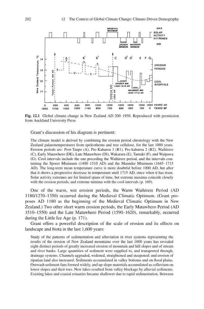
Fig. 12.1 Global climate change in New Zealand AD 200–1950. Reproduced with permission
from Auckland University Press
Grant’s discussion of his diagram is pertinent:
The climate model is derived by combining the erosion period chronology with the New
Zealand palaeotemperatures from speleothems and tree cellulose, for the last 1000 years.
Erosion periods are: Post-Taupo (A), Pre-Kaharoa 1 (B1), Pre-kaharoa 2 (B2), Waihirere
(C), Early Matawhero (DE), Late Matawhero (Dl), Wakarara (E). Tamaki (F), and Waipawa
(G). Cool intervals include the one preceding the Waihirere period, and the intervals containing the Sporer Minimum (1400–1510 AD) and the Maunder Minimum (1645–1715
AD). The long-term mean temperature curve is more doubtful before 1000 AD, but after
that it shows a progressive decrease in temperature until 1715 AD, since when it has risen.
Solar activity extremes are for limited spans of time, but extreme maxima coincide closely
with the erosion periods, and extreme minima with the cool intervals (p. 169).
One of the warm, wet erosion periods, the Warm Waihirere Period (AD
1180/1270–1350) occurred during the Medieval Climatic Optimum. (Grant proposes AD 1180 as the beginning of the Medieval Climatic Optimum in New
Zealand.) Two other short warm erosion periods, the Early Matawhero Period (AD
1510–1550) and the Late Matawhero Period (1590–1620), remarkably, occurred
during the Little Ice Age (p. 171).
Grant offers a powerful description of the scale of erosion and its effects on
landscape and biota in the last 1,600 years:
Study of the patterns of sedimentation and alluviation in river systems representing the
results of the erosion of New Zealand mountains over the last 1600 years has revealed
eight distinct periods of greatly increased erosion of mountain and hill slopes and of stream
and river banks. Large quantities of sediment were supplied to, and transported through,
drainage systems. Channels aggraded, widened, straightened and steepened; and erosion of
riparian land also increased. Sediments accumulated in valley bottoms and on flood plains.
Outwash sediment fans formed widely, and up-slope materials accumulated as colluvium on
lower slopes and their toes. New lakes resulted from valley blockage by alluvial sediments.
Existing lakes and coastal estuaries became shallower due to rapid sedimentation. Between
12 The Context of Global Climate Change: Climate-Driven Demography
Fig. 12.1 Global climate change in New Zealand AD 200–1950. Reproduced with permission
from Auckland University Press
Grant’s discussion of his diagram is pertinent:
The climate model is derived by combining the erosion period chronology with the New
Zealand palaeotemperatures from speleothems and tree cellulose, for the last 1000 years.
Erosion periods are: Post-Taupo (A), Pre-Kaharoa 1 (B1), Pre-kaharoa 2 (B2), Waihirere
(C), Early Matawhero (DE), Late Matawhero (Dl), Wakarara (E). Tamaki (F), and Waipawa
(G). Cool intervals include the one preceding the Waihirere period, and the intervals containing the Sporer Minimum (1400–1510 AD) and the Maunder Minimum (1645–1715
AD). The long-term mean temperature curve is more doubtful before 1000 AD, but after
that it shows a progressive decrease in temperature until 1715 AD, since when it has risen.
Solar activity extremes are for limited spans of time, but extreme maxima coincide closely
with the erosion periods, and extreme minima with the cool intervals (p. 169).
One of the warm, wet erosion periods, the Warm Waihirere Period (AD
1180/1270–1350) occurred during the Medieval Climatic Optimum. (Grant proposes AD 1180 as the beginning of the Medieval Climatic Optimum in New
Zealand.) Two other short warm erosion periods, the Early Matawhero Period (AD
1510–1550) and the Late Matawhero Period (1590–1620), remarkably, occurred
during the Little Ice Age (p. 171).
Grant offers a powerful description of the scale of erosion and its effects on
landscape and biota in the last 1,600 years:
Study of the patterns of sedimentation and alluviation in river systems representing the
results of the erosion of New Zealand mountains over the last 1600 years has revealed
eight distinct periods of greatly increased erosion of mountain and hill slopes and of stream
and river banks. Large quantities of sediment were supplied to, and transported through,
drainage systems. Channels aggraded, widened, straightened and steepened; and erosion of
riparian land also increased. Sediments accumulated in valley bottoms and on flood plains.
Outwash sediment fans formed widely, and up-slope materials accumulated as colluvium on
lower slopes and their toes. New lakes resulted from valley blockage by alluvial sediments.
Existing lakes and coastal estuaries became shallower due to rapid sedimentation. Between