

700
Land-Ocean Systems in the Siberian Arctic: Dynamics and History
Severnaya Zemlya Archipelago and high-altitude areas of the Putoran Plateau and the Byrranga
Mountains (Velichko et aI., 1997, 1997a)_ In the Taymyr region, therefore, both the Late
Quaternary changes in relative influences of the West and East Siberian climates and their
influences on the kind and extension of the Eurasian glaciation can be investigated.
High-arctic
: Tundra .
:.: Arctic :..
-: Tundra :·
· . . . . . . .
. . . . . . .
· , ...... ' , '
:::: Typical ·:::
:.:: Tundra ::.:
.. ', . ' , . ' ,
.... ' ........... ' ... .
· Northern '
:·:: Taiga :.:
90·
100·
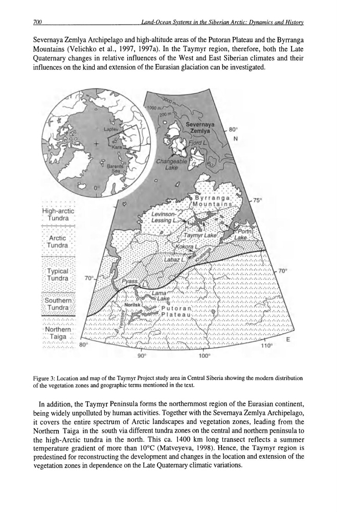
Figure 3: Location and map of the Taymyr Project study area in Central Siberia showing the modern distribution
of the yegetation zones and geographic terms mentioned in the text.
In addition, the Taymyr Peninsula forms the northernmost region of the Eurasian continent,
being widely unpolluted by human activities. Together with the Severnaya Zemlya Archipelago,
it covers the entire spectrum of Arctic landscapes and vegetation zones, leading from the
Northern Taiga in the south via different tundra zones on the central and northern peninsula to
the high-Arctic tundra in the north. This ca. 1400 km long transect reflects a summer
temperature gradient of more than lOoe (Matveyeva, 1998). Hence, the Taymyr region is
predestined for reconstructing the development and changes in the location and extension of the
vegetation zones in dependence on the Late Quaternary climatic variations.
Land-Ocean Systems in the Siberian Arctic: Dynamics and History
Severnaya Zemlya Archipelago and high-altitude areas of the Putoran Plateau and the Byrranga
Mountains (Velichko et aI., 1997, 1997a)_ In the Taymyr region, therefore, both the Late
Quaternary changes in relative influences of the West and East Siberian climates and their
influences on the kind and extension of the Eurasian glaciation can be investigated.
High-arctic
: Tundra .
:.: Arctic :..
-: Tundra :·
· . . . . . . .
. . . . . . .
· , ...... ' , '
:::: Typical ·:::
:.:: Tundra ::.:
.. ', . ' , . ' ,
.... ' ........... ' ... .
· Northern '
:·:: Taiga :.:
90·
100·
Figure 3: Location and map of the Taymyr Project study area in Central Siberia showing the modern distribution
of the yegetation zones and geographic terms mentioned in the text.
In addition, the Taymyr Peninsula forms the northernmost region of the Eurasian continent,
being widely unpolluted by human activities. Together with the Severnaya Zemlya Archipelago,
it covers the entire spectrum of Arctic landscapes and vegetation zones, leading from the
Northern Taiga in the south via different tundra zones on the central and northern peninsula to
the high-Arctic tundra in the north. This ca. 1400 km long transect reflects a summer
temperature gradient of more than lOoe (Matveyeva, 1998). Hence, the Taymyr region is
predestined for reconstructing the development and changes in the location and extension of the
vegetation zones in dependence on the Late Quaternary climatic variations.