

242
Land-Ocean Systems in the Siberian Arctic: Dynamics and History
00
80
60
' ~1
Olenek river -7 5 km below the
Buur river mouth
Vana river - ubJlemaya
Alazeya river - Andryushkino
station
\ = 1 "'5
, ,
~
-
P
2
4
6
8
10
months
12
W - mean-annual water runoff (km 3 ) .
60
20
Lena river - 4.5 km up the
Stolb Island
W ~",76
= 16.7
- mean-annual suspended sediment load (million t);
12
o -
water ronoA' (%);
0 -sedi ment load di charge (%).
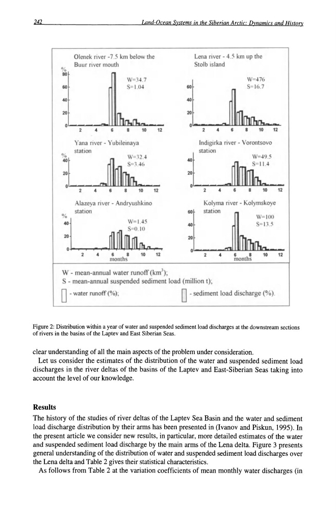
Figure 2: Distribution within a year of water and suspended sediment load discharges at the downstream sections
of rivers in the basins of the Laptev and East Siberian Seas.
clear understanding of all the main aspects of the problem under consideration.
Let us consider the estimates of the distribution of the water and suspended sediment load
discharges in the river deltas of the basins of the Laptev and East-Siberian Seas taking into
account the level of our knowledge.
Results
The history of the studies of river deltas of the Laptev Sea Basin and the water and sediment
load discharge distribution by their arms has been presented in (Ivanov and Piskun, 1995). In
the present article we consider new results, in particular, more detailed estimates of the water
and suspended sediment load discharge by the main arms of the Lena delta. Figure 3 presents
general understanding of the distribution of water and suspended sediment load discharges over
the Lena delta and Table 2 gives their statistical characteristics.
As follows from Table 2 at the variation coefficients of mean monthly water discharges (in
Land-Ocean Systems in the Siberian Arctic: Dynamics and History
00
80
60
' ~1
Olenek river -7 5 km below the
Buur river mouth
Vana river - ubJlemaya
Alazeya river - Andryushkino
station
\ = 1 "'5
, ,
~
-
P
2
4
6
8
10
months
12
W - mean-annual water runoff (km 3 ) .
60
20
Lena river - 4.5 km up the
Stolb Island
W ~",76
= 16.7
- mean-annual suspended sediment load (million t);
12
o -
water ronoA' (%);
0 -sedi ment load di charge (%).
Figure 2: Distribution within a year of water and suspended sediment load discharges at the downstream sections
of rivers in the basins of the Laptev and East Siberian Seas.
clear understanding of all the main aspects of the problem under consideration.
Let us consider the estimates of the distribution of the water and suspended sediment load
discharges in the river deltas of the basins of the Laptev and East-Siberian Seas taking into
account the level of our knowledge.
Results
The history of the studies of river deltas of the Laptev Sea Basin and the water and sediment
load discharge distribution by their arms has been presented in (Ivanov and Piskun, 1995). In
the present article we consider new results, in particular, more detailed estimates of the water
and suspended sediment load discharge by the main arms of the Lena delta. Figure 3 presents
general understanding of the distribution of water and suspended sediment load discharges over
the Lena delta and Table 2 gives their statistical characteristics.
As follows from Table 2 at the variation coefficients of mean monthly water discharges (in