

240
Land-Ocean Systems in the Siberian Arctic: Dynamics and History
of water and sediment load. It also depends on sea level oscillations within seasonal and
synoptic time scales. Depending on the combination of the water content and background sea
level, the distribution of water and sediment load discharges does not remain constant. In the
general case, the water and sediment load discharges in some branches can change not only the
value, but also the direction of the water flow. In channel forked of the second type beyond the
sea influence zone, the distribution of water and sediment load discharges completely depends
on the water content of the river. Due to difficulties in measuring water and sediment load
discharges in the intensive sea influence zone, systematic observations of these regime elements
were organized and are only carried out at the downstream sections of rivers and at the fork
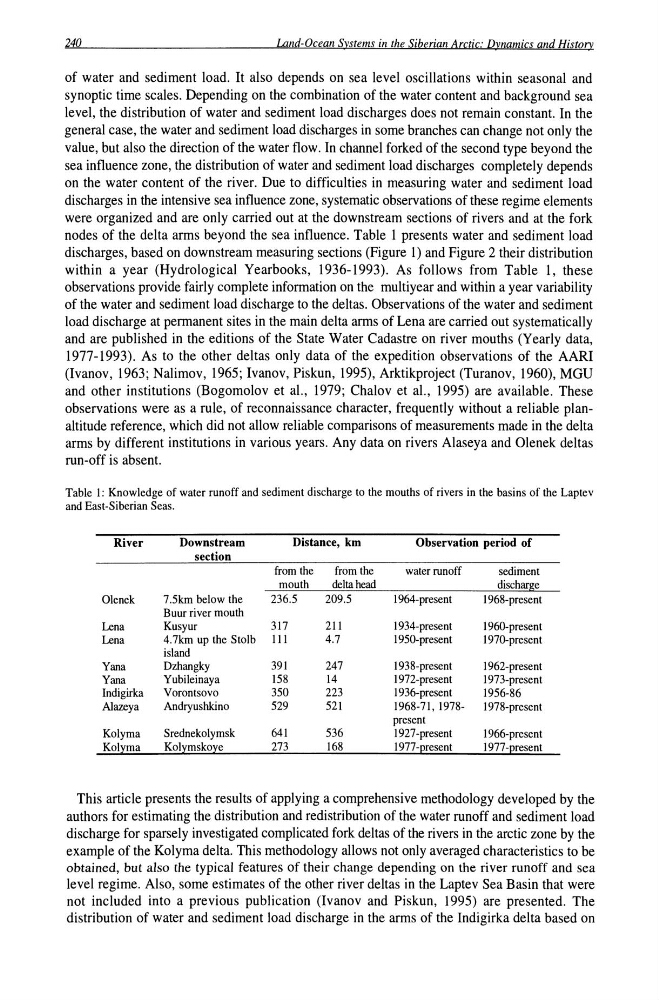
nodes of the delta arms beyond the sea influence. Table 1 presents water and sediment load
discharges, based on downstream measuring sections (Figure 1) and Figure 2 their distribution
within a year (Hydrological Yearbooks, 1936-1993). As follows from Table 1, these
observations provide fairly complete information on the multiyear and within a year variability
of the water and sediment load discharge to the deltas. Observations of the water and sediment
load discharge at permanent sites in the main delta arms of Lena are carried out systematically
and are published in the editions of the State Water Cadastre on river mouths (Yearly data,
1977-1993). As to the other deltas only data of the expedition observations of the AARI
(Ivanov, 1963; Nalimov, 1965; Ivanov, Piskun, 1995), Arktikproject (Turanov, 1960), MGU
and other institutions (Bogomolov et a!., 1979; Chalov et a!., 1995) are available. These
observations were as a rule, of reconnaissance character, frequently without a reliable planaltitude reference, which did not allow reliable comparisons of measurements made in the delta
arms by different institutions in various years. Any data on rivers Alaseya and Olenek deltas
run-off is absent.
Table I: Knowledge of water runoff and sediment discharge to the mouths of rivers in the basins of the Laptev
and East-Siberian Seas.
River
Downstream
Distance, km
Observation period of
section
from the
from the
water runoff
sediment
mouth
delta head
discharge
Olenek
7.5km below the
236.5
209.5
I 964-present
1968-present
Buur river mouth
Lena
Kusyur
317
211
I 934-present
I 960-present
Lena
4.7km up the Stolb III
4.7
I 950-present
I 97G-present
island
Yana
Dzhangky
391
247
1938-present
I 962-present
Yana
Yubileinaya
158
14
I 972-present
I 973-present
Indigirka
Vorontsovo
350
223
1936-present
1956-86
AJazeya
Andryushkino
529
521
1968-71, 1978I 978-present
present
Kolyma
Srednekolymsk
641
536
1927 -present
I 966-present
Kolyma
Kolymskoye
273
168
1977 -present
I 977-present
This article presents the results of applying a comprehensive methodology developed by the
authors for estimating the distribution and redistribution of the water runoff and sediment load
discharge for sparsely investigated complicated fork deltas of the rivers in the arctic zone by the
example of the Kolyma delta. This methodology allows not only averaged characteristics to be
obtained, but also the typical features of their change depending on the river runoff and sea
level regime. Also, some estimates of the other river deltas in the Laptev Sea Basin that were
not included into a previous publication (Ivanov and Piskun, 1995) are presented. The
distribution of water and sediment load discharge in the arms of the Indigirka delta based on
Land-Ocean Systems in the Siberian Arctic: Dynamics and History
of water and sediment load. It also depends on sea level oscillations within seasonal and
synoptic time scales. Depending on the combination of the water content and background sea
level, the distribution of water and sediment load discharges does not remain constant. In the
general case, the water and sediment load discharges in some branches can change not only the
value, but also the direction of the water flow. In channel forked of the second type beyond the
sea influence zone, the distribution of water and sediment load discharges completely depends
on the water content of the river. Due to difficulties in measuring water and sediment load
discharges in the intensive sea influence zone, systematic observations of these regime elements
were organized and are only carried out at the downstream sections of rivers and at the fork
nodes of the delta arms beyond the sea influence. Table 1 presents water and sediment load
discharges, based on downstream measuring sections (Figure 1) and Figure 2 their distribution
within a year (Hydrological Yearbooks, 1936-1993). As follows from Table 1, these
observations provide fairly complete information on the multiyear and within a year variability
of the water and sediment load discharge to the deltas. Observations of the water and sediment
load discharge at permanent sites in the main delta arms of Lena are carried out systematically
and are published in the editions of the State Water Cadastre on river mouths (Yearly data,
1977-1993). As to the other deltas only data of the expedition observations of the AARI
(Ivanov, 1963; Nalimov, 1965; Ivanov, Piskun, 1995), Arktikproject (Turanov, 1960), MGU
and other institutions (Bogomolov et a!., 1979; Chalov et a!., 1995) are available. These
observations were as a rule, of reconnaissance character, frequently without a reliable planaltitude reference, which did not allow reliable comparisons of measurements made in the delta
arms by different institutions in various years. Any data on rivers Alaseya and Olenek deltas
run-off is absent.
Table I: Knowledge of water runoff and sediment discharge to the mouths of rivers in the basins of the Laptev
and East-Siberian Seas.
River
Downstream
Distance, km
Observation period of
section
from the
from the
water runoff
sediment
mouth
delta head
discharge
Olenek
7.5km below the
236.5
209.5
I 964-present
1968-present
Buur river mouth
Lena
Kusyur
317
211
I 934-present
I 960-present
Lena
4.7km up the Stolb III
4.7
I 950-present
I 97G-present
island
Yana
Dzhangky
391
247
1938-present
I 962-present
Yana
Yubileinaya
158
14
I 972-present
I 973-present
Indigirka
Vorontsovo
350
223
1936-present
1956-86
AJazeya
Andryushkino
529
521
1968-71, 1978I 978-present
present
Kolyma
Srednekolymsk
641
536
1927 -present
I 966-present
Kolyma
Kolymskoye
273
168
1977 -present
I 977-present
This article presents the results of applying a comprehensive methodology developed by the
authors for estimating the distribution and redistribution of the water runoff and sediment load
discharge for sparsely investigated complicated fork deltas of the rivers in the arctic zone by the
example of the Kolyma delta. This methodology allows not only averaged characteristics to be
obtained, but also the typical features of their change depending on the river runoff and sea
level regime. Also, some estimates of the other river deltas in the Laptev Sea Basin that were
not included into a previous publication (Ivanov and Piskun, 1995) are presented. The
distribution of water and sediment load discharge in the arms of the Indigirka delta based on