

224
Land-Ocean SYstems in the Siberian Arctic: Dynamics and History
120'
I
Laptev Sea
\
1: Bykovskaya branch
2: TrofllTlvskaya branch
~
3: Olenyoksl
2
\
50'
60'
120'
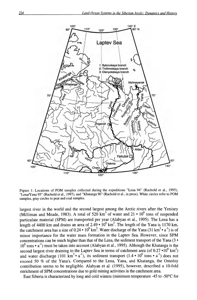
Figure I: Locations of POM samples collected during the expeditions "Lena 94" (Rachold et aI., 1995),
"LenaiYana 95" (Rachold et aI., 1997), and "Khatanga 96" (Rachold et aI., in press). White circles refer to POM
samples, gray circles to peat and coal samples.
largest river in the world and the second largest among the Arctic rivers after the Yenisey
(Milliman and Meade, 1983). A total of 520 km 3 of water and 21 • 10 6 tons of suspended
particulate material (SPM) are transported per year (Alabyan et a!., 1995). The Lena has a
length of 4400 km and drains an area of 2.49· 10 6 km 2 . The length of the Yana is 1170 km,
the catchment area has a size of 0.24· 10 6 km 2 • Water discharge of the Yana (31 km 3 • a-I) is of
minor importance for the water mass formation in the Laptev Sea. However, since SPM
concentrations can be much higher than that of the Lena, the sediment transport of the Yana (3 •
10 6 tons. a-I) must be taken into account (Alabyan et a!., 1995). Although the Khatanga is the
second largest river draining to the Laptev Sea in terms of catchment area (of 0.27 .10 6 km 2 )
and water discharge (101 km 3 • a-I), its sediment transport (1.4.10 6 tons· a-I) does not
exceed 50 % of the Yana's. Compared to the Lena, Yana, and Khatanga, the Omoloy
contribution seems to be negligible. Alabyan et al. (1995), however, described a 10-fold
enrichment of SPM concentrations due to gold mining activities in the catchment area.
East Siberia is characterized by long and cold winters (minimum temperature -45 to -50 D C for
Land-Ocean SYstems in the Siberian Arctic: Dynamics and History
120'
I
Laptev Sea
\
1: Bykovskaya branch
2: TrofllTlvskaya branch
~
3: Olenyoksl
2
\
50'
60'
120'
Figure I: Locations of POM samples collected during the expeditions "Lena 94" (Rachold et aI., 1995),
"LenaiYana 95" (Rachold et aI., 1997), and "Khatanga 96" (Rachold et aI., in press). White circles refer to POM
samples, gray circles to peat and coal samples.
largest river in the world and the second largest among the Arctic rivers after the Yenisey
(Milliman and Meade, 1983). A total of 520 km 3 of water and 21 • 10 6 tons of suspended
particulate material (SPM) are transported per year (Alabyan et a!., 1995). The Lena has a
length of 4400 km and drains an area of 2.49· 10 6 km 2 . The length of the Yana is 1170 km,
the catchment area has a size of 0.24· 10 6 km 2 • Water discharge of the Yana (31 km 3 • a-I) is of
minor importance for the water mass formation in the Laptev Sea. However, since SPM
concentrations can be much higher than that of the Lena, the sediment transport of the Yana (3 •
10 6 tons. a-I) must be taken into account (Alabyan et a!., 1995). Although the Khatanga is the
second largest river draining to the Laptev Sea in terms of catchment area (of 0.27 .10 6 km 2 )
and water discharge (101 km 3 • a-I), its sediment transport (1.4.10 6 tons· a-I) does not
exceed 50 % of the Yana's. Compared to the Lena, Yana, and Khatanga, the Omoloy
contribution seems to be negligible. Alabyan et al. (1995), however, described a 10-fold
enrichment of SPM concentrations due to gold mining activities in the catchment area.
East Siberia is characterized by long and cold winters (minimum temperature -45 to -50 D C for