

150 Ma (Torsvik et al., 2009). The Mongol–Okhotsk
Ocean is almost entirely closed, with complete closure
dated at around 150 Ma based on the cessation of compression in the suture zone region (Zorin, 1999).
140 Ma
This reconstruction illustrates the initial formation of the
proto-Caribbean between North and South America as a
consequence of the divergence between Laurasia and
Gondwanaland. In the Arctic Ocean, the Canada Basin
started forming via counterclockwise rotation of the North
Slope of Alaska away from the northern Canadian margin
(Halgedahl and Jarrard, 1987), with seafloor spreading
starting at 142 Ma (Alvey et al., 2008). The Canada Basin
spreading ridge is connected with the North Atlantic rift
zone, which in turn connects to the northern Tethyan subduction zone and the central North Atlantic spreading
ridge (Figure 3d). The neo-Tethys started forming prior
to 140 Ma, best documented by the separation of Argoland
from the northwest shelf of Australia around 155 Ma
(Gibbons et al., 2012). The neo-Tethyan mid-ocean ridge
likely wrapped around northern India and is assumed to
have connected with seafloor spreading in the Somali
Basin (Figure 3d). This incipient spreading system continued south into the Mozambique Basin, the Riser-Larson,
and the Weddell seas, marking the fragmentation of Gondwanaland. The southwest Panthalassic margin, along
eastern Australia, involved the opening of the South Loyalty Basin, due to rollback of the southwest Panthalassic
subduction zone from 140 Ma.
120 Ma
This time marks a significant increase in seafloor spreading rates in Panthalassa corresponding to the
mid-Cretaceous seafloor spreading pulse, with spreading
between the Pacific, Farallon, Izanagi, and Phoenix plates.
The breakup of the Phoenix plate occurred due to the eruption of a suite of LIPs, most notably the Ontong Java,
Manihiki, and Hikurangi Plateaus, which originally
formed one giant oceanic plateau (Taylor, 2006)
(Figure 3e). The eruption of this mega-LIP led directly
to the formation of the Hikurangi, Manihiki, Chasca, and
Catequil plates (Figure 3e). Additional two triple junctions
were active in the region leading to the breakup of the eastern Manihiki Plateau and the development of the Tongareva triple junction. The South Loyalty Basin off
northeast Australia was actively opening until 120 Ma,
when it was halted by a major change in the plate configurations in the SW Panthalassic Ocean. After a landward
ridge jump of the neo-Tethys ridge at 135 Ma, the
mid-ocean ridge propagated southward to open the
Gascoyne, Cuvier, and Perth Abyssal Plains between
India and Australia (Gibbons et al., 2012). The West Australian spreading ridge system joined with the Enderby
180˚ 120˚W 60˚W 0˚
60˚E 120˚E
90˚S
60˚S
30˚S
0˚
30˚N
60˚N
90˚N
i
j
k
180˚ 120˚W 60˚W 0˚
60˚E 120˚E
90˚S
60˚S
30˚S
0˚
30˚N
60˚N
90˚N
90˚S
60˚S
3
3
60˚N
90 N
i
40 Ma
Pacific
Arctic
South
Atlantic
Indian
NeoTethys
Southern
North
Atlantic
j
180˚ 120˚W 60˚W 0˚
60˚E 120˚E
90˚S
60˚S
30˚S
0˚
30˚N
60˚N
90˚N
20 Ma
Pacific
Arctic
South
Atlantic
Indian
Southern
North
Atlantic
k
90˚S
60˚S
3
60˚N
90 N
− 5 4 0 0
− 5 2 0 0
− 5 0 0 0
− 4 8 0 0
− 4 6 0 0
− 4 4 0 0
− 4 2 0 0
− 4 0 0 0
− 3 8 0 0
− 3 6 0 0
− 3 4 0 0
− 3 2 0 0
− 3 0 0 0
− 2 8 0 0
− 2 6 0 0
− 2 4 0 0
Bathymetry based on GDH1 [m]
0 Ma
Pacific
Arctic
South
Atlantic
Indian
Southern
North
Atlantic
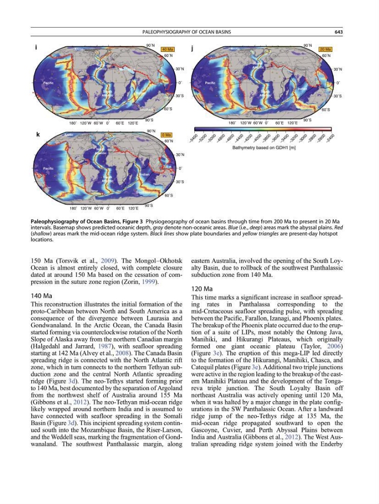
Paleophysiography of Ocean Basins, Figure 3 Physiogeography of ocean basins through time from 200 Ma to present in 20 Ma
intervals. Basemap shows predicted oceanic depth, gray denote non-oceanic areas. Blue (i.e., deep) areas mark the abyssal plains. Red
(shallow) areas mark the mid-ocean ridge system. Black lines show plate boundaries and yellow triangles are present-day hotspot
locations.
PALEOPHYSIOGRAPHY OF OCEAN BASINS
643