

Back-arc spreading models predict the axis of marginal
sea opening should be parallel to the subduction trench
and island arc; but this is not always seen. For the marginal
seas do not have trench-parallel axes, non-back-arc
spreading models are proposed. The slab-pull model
(Model 6) suggests the marginal sea opened by the pulling
force of a frontal subducting oceanic slab. This driving
force is caused by the negative buoyancy, which occurs
when the heavier oceanic slab subducts into the lighter
asthenosphere. Other non-back-arc spreading models are
related to tectonic forces. For example, the pull-apart
model (Model 7) suggests that the marginal sea was
formed by the pull-apart force associated with large
strike-slip fault(s).
Features of marginal seas in geographic and
oceanographic context
Water circulation
Water circulation patterns in marginal seas depend largely
on bathymetry, freshwater input (e.g., river runoff and precipitation), evaporation, and connectivity to the open
ocean circulations.
As marginal seas are highly isolated from the open
ocean, the water circulation is dependent largely on the
balance between freshwater input and evaporation. If
freshwater input exceeds evaporation, as is the case in
the Black and Baltic Seas, the excess freshwater will tend
to flow seaward near the sea surface, diluting the marginal
sea. If evaporation exceeds freshwater input, as in the
Mediterranean Sea, the marginal seawater becomes saltier
and then sinks and flows near the bottom toward the less
salty open ocean. These general water circulation patterns
are often modified by local bathymetry, which in some
instances serve to restrict water flow (Water
Encyclopedia).
In the marginal seas with relatively good connection
with open oceans, the water circulation is significantly
influenced by the connectivity to the open ocean circulations, which is in turn influenced by the sea-level changes.
For example, in the system of western Pacific marginal
seas, the water circulation is strongly influenced by the
inflow of the western boundary currents (Kuroshio and
Oyashio) of the western Pacific Ocean (Figure 3). During
glacial periods, the sea-level is low and the boundary currents are flowing only outside the marginal seas, while in
interglacial periods, the western boundary currents are
partially running through the marginal seas. This change
in water circulation might influence the climate system
of the Earth. For example, the reduction of Kuroshio warm
water in glacial times decreased heat and humidity supply
to East Asia (Wang, 1999).
Sedimentation
The marginal seas intercepted the flux of terrigenous sediments from continents and have the sedimentation rates
one or two orders of magnitude higher than the sedimentation rates in open oceans. This is responsible for the development of wide continental shelves in marginal seas, such
as in the marginal seas between Asia and western Pacific
Ocean. Although South and East Asian continent and their
E
S
E
W
N
Adaman
S.China
W.Philippine
Sulu
Celebes
Makassar
Molucca Banda
Okinawa
Shikoku
Mariana
Palece Vela
Caroline
Kuril
Japan
Konandosky Alutian
Manus
Solomon
Woodlark
Coral
Loyalty
N.Fiji
Lau-Harve
S.Fiji
New Caledonia
Tasman
Emerald
Cayman
Caribbean
Central
Scotia
E.Scotia
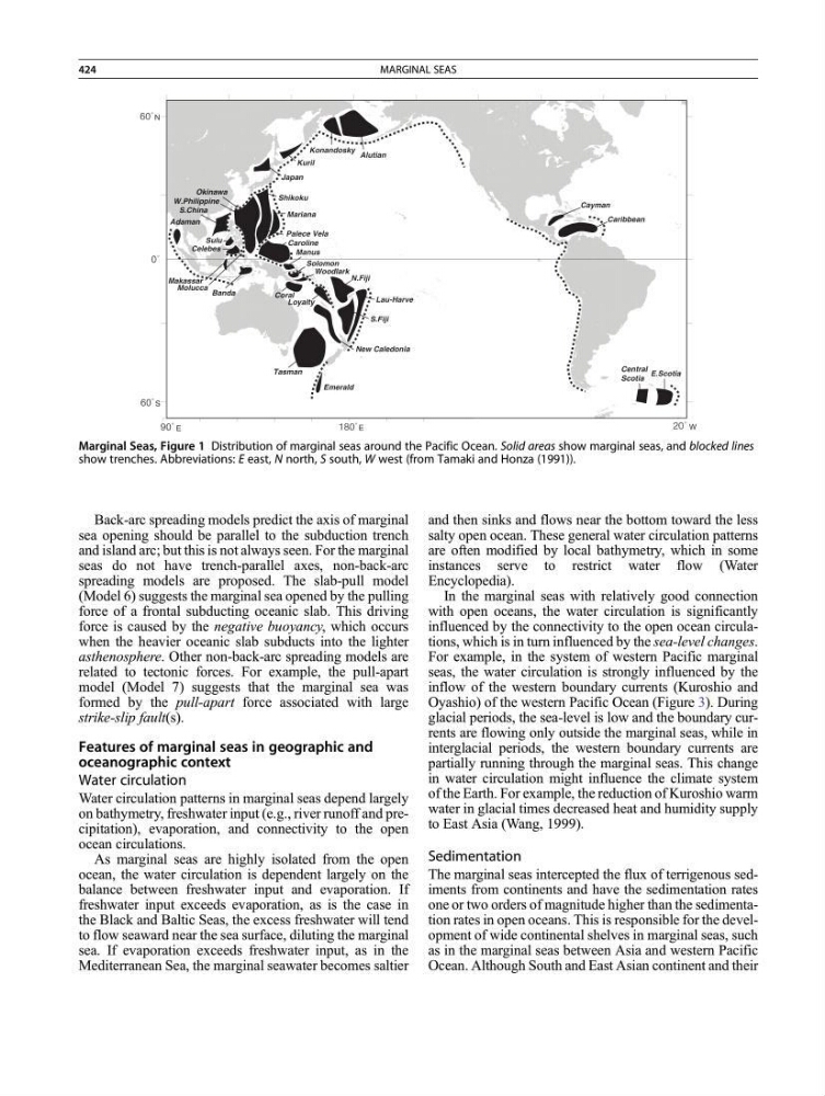
Marginal Seas, Figure 1 Distribution of marginal seas around the Pacific Ocean. Solid areas show marginal seas, and blocked lines
show trenches. Abbreviations: E east, N north, S south, W west (from Tamaki and Honza (1991)).
424
MARGINAL SEAS
sea opening should be parallel to the subduction trench
and island arc; but this is not always seen. For the marginal
seas do not have trench-parallel axes, non-back-arc
spreading models are proposed. The slab-pull model
(Model 6) suggests the marginal sea opened by the pulling
force of a frontal subducting oceanic slab. This driving
force is caused by the negative buoyancy, which occurs
when the heavier oceanic slab subducts into the lighter
asthenosphere. Other non-back-arc spreading models are
related to tectonic forces. For example, the pull-apart
model (Model 7) suggests that the marginal sea was
formed by the pull-apart force associated with large
strike-slip fault(s).
Features of marginal seas in geographic and
oceanographic context
Water circulation
Water circulation patterns in marginal seas depend largely
on bathymetry, freshwater input (e.g., river runoff and precipitation), evaporation, and connectivity to the open
ocean circulations.
As marginal seas are highly isolated from the open
ocean, the water circulation is dependent largely on the
balance between freshwater input and evaporation. If
freshwater input exceeds evaporation, as is the case in
the Black and Baltic Seas, the excess freshwater will tend
to flow seaward near the sea surface, diluting the marginal
sea. If evaporation exceeds freshwater input, as in the
Mediterranean Sea, the marginal seawater becomes saltier
and then sinks and flows near the bottom toward the less
salty open ocean. These general water circulation patterns
are often modified by local bathymetry, which in some
instances serve to restrict water flow (Water
Encyclopedia).
In the marginal seas with relatively good connection
with open oceans, the water circulation is significantly
influenced by the connectivity to the open ocean circulations, which is in turn influenced by the sea-level changes.
For example, in the system of western Pacific marginal
seas, the water circulation is strongly influenced by the
inflow of the western boundary currents (Kuroshio and
Oyashio) of the western Pacific Ocean (Figure 3). During
glacial periods, the sea-level is low and the boundary currents are flowing only outside the marginal seas, while in
interglacial periods, the western boundary currents are
partially running through the marginal seas. This change
in water circulation might influence the climate system
of the Earth. For example, the reduction of Kuroshio warm
water in glacial times decreased heat and humidity supply
to East Asia (Wang, 1999).
Sedimentation
The marginal seas intercepted the flux of terrigenous sediments from continents and have the sedimentation rates
one or two orders of magnitude higher than the sedimentation rates in open oceans. This is responsible for the development of wide continental shelves in marginal seas, such
as in the marginal seas between Asia and western Pacific
Ocean. Although South and East Asian continent and their
E
S
E
W
N
Adaman
S.China
W.Philippine
Sulu
Celebes
Makassar
Molucca Banda
Okinawa
Shikoku
Mariana
Palece Vela
Caroline
Kuril
Japan
Konandosky Alutian
Manus
Solomon
Woodlark
Coral
Loyalty
N.Fiji
Lau-Harve
S.Fiji
New Caledonia
Tasman
Emerald
Cayman
Caribbean
Central
Scotia
E.Scotia
Marginal Seas, Figure 1 Distribution of marginal seas around the Pacific Ocean. Solid areas show marginal seas, and blocked lines
show trenches. Abbreviations: E east, N north, S south, W west (from Tamaki and Honza (1991)).
424
MARGINAL SEAS