

Bibliography
Frisch, W., Meschede, M., and Blakey, R., 2011. Plate Tectonics.
Continental Drift and Mountain Building. Berlin/Heidelberg:
Springer. 212 pp.
Green, H. W., 1994. Solving the paradox of deep earthquakes. Scientific American, 271(3), 50–57.
Isacks, B., and Molnar, P., 1969. Mantle earthquake
mechanisms and the sinking of the lithosphere. Nature, 223,
1121–1124.
Okomura, K., Yoshioka, T., and Kuscu, I., 1993. Surface faulting on
the North Anatolian Fault in these two millennia. U.S. Geological Survey Open-File Report, 94–568, pp. 143–144.
Sieh, K. E., 1978. Prehistoric large earthquakes produced by slip on
the San Andreas fault at Pallett Creek, California. Journal of
Geophysical Research, 83, 3907–3939.
Sykes, L. R., 1967. Mechanism of earthquakes and nature of
faulting on the mid-ocean ridges. Journal of Geophysical
Research, 72, 2131–2153.
Cross-references
Earthquakes
Epicenter, Hypocenter
FJORDS
Antoon Kuijpers and Camilla S. Andresen
Geological Survey of Denmark and Greenland (GEUS),
Copenhagen, Denmark
Definition
Fjords are defined as deep, elongated arms of the sea that
have been (or are presently being) excavated or modified
by land-based glaciers (Syvitski et al., 1987).
Summary
The term “fjord” has its origin in the Old Norse word
“fjorthr” which also included freshwater lakes. However,
according to above definition, we will deal here exclusively with deep, semi-enclosed coastal inlets that generally are long relative to their width. Globally, almost all
fjords are found at higher latitude, i.e., north of 43
and
south of 42
. The longest (>200 km) fjords are Scoresby
Sund, East Greenland, and Sognefjord in Norway. The
inland termination and seaward opening of the fjord are
referred to as head and mouth, respectively. Fjord topography is often characterized by one or more submarine sills
representing relict moraines or bedrock ridges. Sediments
from fjord basins may provide high-resolution records of
both marine and terrestrial environmental changes
(Gilbert, 2000), with maximum accumulation rates
amounting to more than 1 m per year (Syvitski and
Farrow, 1989). Sedimentation patterns in the fjord are controlled by glacial and fluvial conditions, topography, sealevel, and hydrography of coastal waters (Syvitski et al.,
1987). Usually, an estuarine circulation regime with a
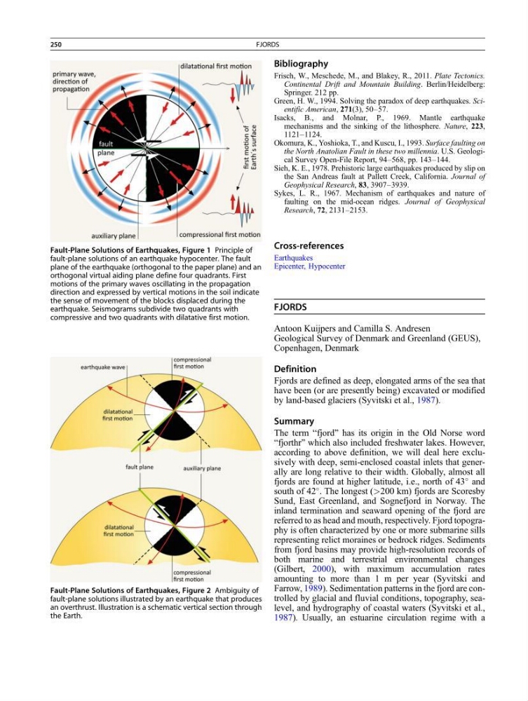
Fault-Plane Solutions of Earthquakes, Figure 1 Principle of
fault-plane solutions of an earthquake hypocenter. The fault
plane of the earthquake (orthogonal to the paper plane) and an
orthogonal virtual aiding plane define four quadrants. First
motions of the primary waves oscillating in the propagation
direction and expressed by vertical motions in the soil indicate
the sense of movement of the blocks displaced during the
earthquake. Seismograms subdivide two quadrants with
compressive and two quadrants with dilatative first motion.
Fault-Plane Solutions of Earthquakes, Figure 2 Ambiguity of
fault-plane solutions illustrated by an earthquake that produces
an overthrust. Illustration is a schematic vertical section through
the Earth.
250
FJORDS
Frisch, W., Meschede, M., and Blakey, R., 2011. Plate Tectonics.
Continental Drift and Mountain Building. Berlin/Heidelberg:
Springer. 212 pp.
Green, H. W., 1994. Solving the paradox of deep earthquakes. Scientific American, 271(3), 50–57.
Isacks, B., and Molnar, P., 1969. Mantle earthquake
mechanisms and the sinking of the lithosphere. Nature, 223,
1121–1124.
Okomura, K., Yoshioka, T., and Kuscu, I., 1993. Surface faulting on
the North Anatolian Fault in these two millennia. U.S. Geological Survey Open-File Report, 94–568, pp. 143–144.
Sieh, K. E., 1978. Prehistoric large earthquakes produced by slip on
the San Andreas fault at Pallett Creek, California. Journal of
Geophysical Research, 83, 3907–3939.
Sykes, L. R., 1967. Mechanism of earthquakes and nature of
faulting on the mid-ocean ridges. Journal of Geophysical
Research, 72, 2131–2153.
Cross-references
Earthquakes
Epicenter, Hypocenter
FJORDS
Antoon Kuijpers and Camilla S. Andresen
Geological Survey of Denmark and Greenland (GEUS),
Copenhagen, Denmark
Definition
Fjords are defined as deep, elongated arms of the sea that
have been (or are presently being) excavated or modified
by land-based glaciers (Syvitski et al., 1987).
Summary
The term “fjord” has its origin in the Old Norse word
“fjorthr” which also included freshwater lakes. However,
according to above definition, we will deal here exclusively with deep, semi-enclosed coastal inlets that generally are long relative to their width. Globally, almost all
fjords are found at higher latitude, i.e., north of 43
and
south of 42
. The longest (>200 km) fjords are Scoresby
Sund, East Greenland, and Sognefjord in Norway. The
inland termination and seaward opening of the fjord are
referred to as head and mouth, respectively. Fjord topography is often characterized by one or more submarine sills
representing relict moraines or bedrock ridges. Sediments
from fjord basins may provide high-resolution records of
both marine and terrestrial environmental changes
(Gilbert, 2000), with maximum accumulation rates
amounting to more than 1 m per year (Syvitski and
Farrow, 1989). Sedimentation patterns in the fjord are controlled by glacial and fluvial conditions, topography, sealevel, and hydrography of coastal waters (Syvitski et al.,
1987). Usually, an estuarine circulation regime with a
Fault-Plane Solutions of Earthquakes, Figure 1 Principle of
fault-plane solutions of an earthquake hypocenter. The fault
plane of the earthquake (orthogonal to the paper plane) and an
orthogonal virtual aiding plane define four quadrants. First
motions of the primary waves oscillating in the propagation
direction and expressed by vertical motions in the soil indicate
the sense of movement of the blocks displaced during the
earthquake. Seismograms subdivide two quadrants with
compressive and two quadrants with dilatative first motion.
Fault-Plane Solutions of Earthquakes, Figure 2 Ambiguity of
fault-plane solutions illustrated by an earthquake that produces
an overthrust. Illustration is a schematic vertical section through
the Earth.
250
FJORDS