

with the buildup of Antarctic and then northern hemisphere ice sheets since the end of the Eocene. Once deposited on the continental rise, there is no place else to go for
the sediment except further out onto the abyssal plains.
Detrital sediment reaches the continental rise by three
mechanisms. First is simply settling through the water column. The oceanic frontal systems separating the brown
turbid waters of the continental shelves from the blue
waters of the open ocean generally prevent riverinesuspended sediment from being fed into the surface ocean.
However, the supply of dust from land is also large, and
this settles into the ocean and becomes a part of the rain
of pelagic sediment to the deep sea. There is no special
supply of dust to the continental rise.
The second mechanism is through turbidity currents.
Fresh riverine waters with a significant suspended sediment load have a density greater than seawater and can
flow across the shelf and down onto the slope and rise as
turbidity currents. Because the density of seawater
increases with the depth of these turbidity currents, upon
reaching seawater of equal density the turbid flow may
mix with the seawater or flow out on a density surface.
The third mechanism is through failures of the sediments of the continental slope as slumps or catastrophic
slides into the deep sea. Gradual slumping appears to be
a common process where there is a large sediment supply
to a steep slope. Landslides from the slope to the deep sea
are much more common than had originally been thought.
They seem to occur especially in regions where gas clathrates that acted as cement stabilizing the slope decompose
as warming of the waters occurs, as during glacial terminations (Bryn et al., 2006). The usual triggering mechanism
is thought to be earthquakes, but large storms may also be
a cause. Probably half of the sediment in the continental
rise reached its present location through mass movements.
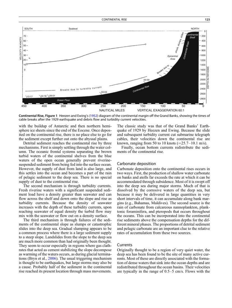
The classic study was that of the Grand Banks’ Earthquake of 1929 by Heezen and Ewing. Because the slide
and subsequent turbidity current cut submarine telegraph
cables, their velocities down the continental rise are
known, ranging from 50 to 10 knots (¼25.7–10.1 m/s).
Finally, ocean bottom currents redistribute the sediments of the continental rise.
Carbonate deposition
Carbonate deposition onto the continental rises occurs in
two ways. First, the production of shallow water carbonate
on banks and atolls far exceeds the rate at which it can be
accommodated through subsidence. Most of it is swept off
into the deep sea during major storms. Much of that is
dissolved by the corrosive waters of the deep sea, but
because it may be delivered in large quantities in very
short intervals of time, it can accumulate along bank margins (e.g., Bahamas, Maldives). The second source is the
rain of carbonate from calcareous nannoplankton, planktonic foraminifera, and pteropods that occurs throughout
the oceans. This can be incorporated into the continental
rise sediments above the compensation depths for the different mineral phases. The proportions of detrital sediment
and pelagic carbonate are an important clue to the relative
rates of accumulation from these two sources.
Currents
Originally thought to be a region of very quiet water, the
deep sea has been found to be the site of many active currents. Most of these are directly associated with the formation of dense waters that sink into the ocean depths and are
redistributed throughout the ocean basins. Their velocities
are typically in the range of 0.5–5 cm/s. Flows with the
450
400
350
300
250
200
150
50
0
2800
2600
2400
2200
2000
1800
1600
1400
1200
1000
800
600
Epicentral
Area
00:59
03:03
09:01
10:18
0
10
20
30
40
50
60
70
SOUTH
Sealevel
VELOCITY IN KNOTS
DEPTH IN FATHOMS
13:17
B r e a k s d u e to
400
200
sh o ck , sl u m p s, sl id e s
0
NORTH
Continental
Shelf
C on tin en ta l Sl op e
C o n tin e n ta l R is e
Ocean Floor
100
VERTICAL EXAGGERATION 60:1
NAUTICAL MILES
B r e a k s d u e t o t u r b i d i t y c u r r e n t
Continental Rise, Figure 1 Heezen and Ewing’s (1952) diagram of the continental margin off the Grand Banks, showing the times of
cable breaks after the 1929 earthquake and debris flow and turbidity current velocities.
CONTINENTAL RISE
123
the sediment except further out onto the abyssal plains.
Detrital sediment reaches the continental rise by three
mechanisms. First is simply settling through the water column. The oceanic frontal systems separating the brown
turbid waters of the continental shelves from the blue
waters of the open ocean generally prevent riverinesuspended sediment from being fed into the surface ocean.
However, the supply of dust from land is also large, and
this settles into the ocean and becomes a part of the rain
of pelagic sediment to the deep sea. There is no special
supply of dust to the continental rise.
The second mechanism is through turbidity currents.
Fresh riverine waters with a significant suspended sediment load have a density greater than seawater and can
flow across the shelf and down onto the slope and rise as
turbidity currents. Because the density of seawater
increases with the depth of these turbidity currents, upon
reaching seawater of equal density the turbid flow may
mix with the seawater or flow out on a density surface.
The third mechanism is through failures of the sediments of the continental slope as slumps or catastrophic
slides into the deep sea. Gradual slumping appears to be
a common process where there is a large sediment supply
to a steep slope. Landslides from the slope to the deep sea
are much more common than had originally been thought.
They seem to occur especially in regions where gas clathrates that acted as cement stabilizing the slope decompose
as warming of the waters occurs, as during glacial terminations (Bryn et al., 2006). The usual triggering mechanism
is thought to be earthquakes, but large storms may also be
a cause. Probably half of the sediment in the continental
rise reached its present location through mass movements.
The classic study was that of the Grand Banks’ Earthquake of 1929 by Heezen and Ewing. Because the slide
and subsequent turbidity current cut submarine telegraph
cables, their velocities down the continental rise are
known, ranging from 50 to 10 knots (¼25.7–10.1 m/s).
Finally, ocean bottom currents redistribute the sediments of the continental rise.
Carbonate deposition
Carbonate deposition onto the continental rises occurs in
two ways. First, the production of shallow water carbonate
on banks and atolls far exceeds the rate at which it can be
accommodated through subsidence. Most of it is swept off
into the deep sea during major storms. Much of that is
dissolved by the corrosive waters of the deep sea, but
because it may be delivered in large quantities in very
short intervals of time, it can accumulate along bank margins (e.g., Bahamas, Maldives). The second source is the
rain of carbonate from calcareous nannoplankton, planktonic foraminifera, and pteropods that occurs throughout
the oceans. This can be incorporated into the continental
rise sediments above the compensation depths for the different mineral phases. The proportions of detrital sediment
and pelagic carbonate are an important clue to the relative
rates of accumulation from these two sources.
Currents
Originally thought to be a region of very quiet water, the
deep sea has been found to be the site of many active currents. Most of these are directly associated with the formation of dense waters that sink into the ocean depths and are
redistributed throughout the ocean basins. Their velocities
are typically in the range of 0.5–5 cm/s. Flows with the
450
400
350
300
250
200
150
50
0
2800
2600
2400
2200
2000
1800
1600
1400
1200
1000
800
600
Epicentral
Area
00:59
03:03
09:01
10:18
0
10
20
30
40
50
60
70
SOUTH
Sealevel
VELOCITY IN KNOTS
DEPTH IN FATHOMS
13:17
B r e a k s d u e to
400
200
sh o ck , sl u m p s, sl id e s
0
NORTH
Continental
Shelf
C on tin en ta l Sl op e
C o n tin e n ta l R is e
Ocean Floor
100
VERTICAL EXAGGERATION 60:1
NAUTICAL MILES
B r e a k s d u e t o t u r b i d i t y c u r r e n t
Continental Rise, Figure 1 Heezen and Ewing’s (1952) diagram of the continental margin off the Grand Banks, showing the times of
cable breaks after the 1929 earthquake and debris flow and turbidity current velocities.
CONTINENTAL RISE
123