

biological and physical processes of both terrestrial and
marine environments. In this sense it is broadly defined
for the purpose of natural resources management
(Cullinan, 2006). It should be noted that coastal area
boundaries change over time without regard to enabling
legislation.
Determination of coastline length:
the coastline paradox
Application of the term coast is conditioned by scale, purpose of the designation, and the audience or user. The socalled coastline paradox states that a coastline does not
have a well-defined length because its measurement is
scale dependent. Measurements of the length of
a coastline behave like a fractal, being different at varying
scale intervals. The smaller the scale interval (the shorter
in length, the more detailed the measurement), the longer
the coastline. This “magnifying” effect occurs because it
takes many more shorter scalar lengths to measure the
coastline, and consequently, coastline length becomes
greater for convoluted coastlines than for relatively
smooth ones. Convoluted coastlines tend to obtain for
rocky coasts, and determination of coastline length in
these situations can be especially problematic. One solution, as proposed by Spagnolo et al. (2008), is the indentation index, which is defined as the ratio between the real
length of a coast and its Euclidean length. Application of
this method involves digitizing the coastline in a GIS platform to test several Euclidean length values on the same
coastline, thereby obtaining a different spatial variability
of the indentation index with each trial. The best length
values that maximize the spatial variability of the indentation index determine an indentation index pattern of high
variance and low spatial autocorrelation. This procedure
has applicability to some rocky coasts of limited extent
but is limited by the scale of operation in a GIS where it
would not be practical to determine world rocky coast
lengths.
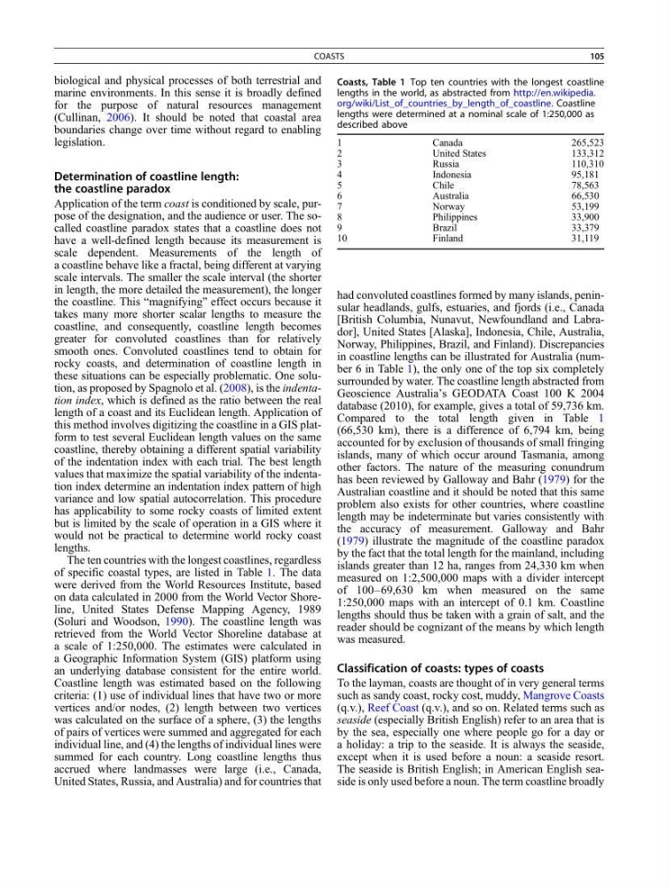
The ten countries with the longest coastlines, regardless
of specific coastal types, are listed in Table 1. The data
were derived from the World Resources Institute, based
on data calculated in 2000 from the World Vector Shoreline, United States Defense Mapping Agency, 1989
(Soluri and Woodson, 1990). The coastline length was
retrieved from the World Vector Shoreline database at
a scale of 1:250,000. The estimates were calculated in
a Geographic Information System (GIS) platform using
an underlying database consistent for the entire world.
Coastline length was estimated based on the following
criteria: (1) use of individual lines that have two or more
vertices and/or nodes, (2) length between two vertices
was calculated on the surface of a sphere, (3) the lengths
of pairs of vertices were summed and aggregated for each
individual line, and (4) the lengths of individual lines were
summed for each country. Long coastline lengths thus
accrued where landmasses were large (i.e., Canada,
United States, Russia, and Australia) and for countries that
had convoluted coastlines formed by many islands, peninsular headlands, gulfs, estuaries, and fjords (i.e., Canada
[British Columbia, Nunavut, Newfoundland and Labrador], United States [Alaska], Indonesia, Chile, Australia,
Norway, Philippines, Brazil, and Finland). Discrepancies
in coastline lengths can be illustrated for Australia (number 6 in Table 1), the only one of the top six completely
surrounded by water. The coastline length abstracted from
Geoscience Australia’s GEODATA Coast 100 K 2004
database (2010), for example, gives a total of 59,736 km.
Compared to the total length given in Table 1
(66,530 km), there is a difference of 6,794 km, being
accounted for by exclusion of thousands of small fringing
islands, many of which occur around Tasmania, among
other factors. The nature of the measuring conundrum
has been reviewed by Galloway and Bahr (1979) for the
Australian coastline and it should be noted that this same
problem also exists for other countries, where coastline
length may be indeterminate but varies consistently with
the accuracy of measurement. Galloway and Bahr
(1979) illustrate the magnitude of the coastline paradox
by the fact that the total length for the mainland, including
islands greater than 12 ha, ranges from 24,330 km when
measured on 1:2,500,000 maps with a divider intercept
of 100–69,630 km when measured on the same
1:250,000 maps with an intercept of 0.1 km. Coastline
lengths should thus be taken with a grain of salt, and the
reader should be cognizant of the means by which length
was measured.
Classification of coasts: types of coasts
To the layman, coasts are thought of in very general terms
such as sandy coast, rocky cost, muddy, Mangrove Coasts
(q.v.), Reef Coast (q.v.), and so on. Related terms such as
seaside (especially British English) refer to an area that is
by the sea, especially one where people go for a day or
a holiday: a trip to the seaside. It is always the seaside,
except when it is used before a noun: a seaside resort.
The seaside is British English; in American English seaside is only used before a noun. The term coastline broadly
Coasts, Table 1 Top ten countries with the longest coastline
lengths in the world, as abstracted from http://en.wikipedia.
org/wiki/List_of_countries_by_length_of_coastline. Coastline
lengths were determined at a nominal scale of 1:250,000 as
described above
1
Canada
265,523
2
United States
133,312
3
Russia
110,310
4
Indonesia
95,181
5
Chile
78,563
6
Australia
66,530
7
Norway
53,199
8
Philippines
33,900
9
Brazil
33,379
10
Finland
31,119
COASTS
105
marine environments. In this sense it is broadly defined
for the purpose of natural resources management
(Cullinan, 2006). It should be noted that coastal area
boundaries change over time without regard to enabling
legislation.
Determination of coastline length:
the coastline paradox
Application of the term coast is conditioned by scale, purpose of the designation, and the audience or user. The socalled coastline paradox states that a coastline does not
have a well-defined length because its measurement is
scale dependent. Measurements of the length of
a coastline behave like a fractal, being different at varying
scale intervals. The smaller the scale interval (the shorter
in length, the more detailed the measurement), the longer
the coastline. This “magnifying” effect occurs because it
takes many more shorter scalar lengths to measure the
coastline, and consequently, coastline length becomes
greater for convoluted coastlines than for relatively
smooth ones. Convoluted coastlines tend to obtain for
rocky coasts, and determination of coastline length in
these situations can be especially problematic. One solution, as proposed by Spagnolo et al. (2008), is the indentation index, which is defined as the ratio between the real
length of a coast and its Euclidean length. Application of
this method involves digitizing the coastline in a GIS platform to test several Euclidean length values on the same
coastline, thereby obtaining a different spatial variability
of the indentation index with each trial. The best length
values that maximize the spatial variability of the indentation index determine an indentation index pattern of high
variance and low spatial autocorrelation. This procedure
has applicability to some rocky coasts of limited extent
but is limited by the scale of operation in a GIS where it
would not be practical to determine world rocky coast
lengths.
The ten countries with the longest coastlines, regardless
of specific coastal types, are listed in Table 1. The data
were derived from the World Resources Institute, based
on data calculated in 2000 from the World Vector Shoreline, United States Defense Mapping Agency, 1989
(Soluri and Woodson, 1990). The coastline length was
retrieved from the World Vector Shoreline database at
a scale of 1:250,000. The estimates were calculated in
a Geographic Information System (GIS) platform using
an underlying database consistent for the entire world.
Coastline length was estimated based on the following
criteria: (1) use of individual lines that have two or more
vertices and/or nodes, (2) length between two vertices
was calculated on the surface of a sphere, (3) the lengths
of pairs of vertices were summed and aggregated for each
individual line, and (4) the lengths of individual lines were
summed for each country. Long coastline lengths thus
accrued where landmasses were large (i.e., Canada,
United States, Russia, and Australia) and for countries that
had convoluted coastlines formed by many islands, peninsular headlands, gulfs, estuaries, and fjords (i.e., Canada
[British Columbia, Nunavut, Newfoundland and Labrador], United States [Alaska], Indonesia, Chile, Australia,
Norway, Philippines, Brazil, and Finland). Discrepancies
in coastline lengths can be illustrated for Australia (number 6 in Table 1), the only one of the top six completely
surrounded by water. The coastline length abstracted from
Geoscience Australia’s GEODATA Coast 100 K 2004
database (2010), for example, gives a total of 59,736 km.
Compared to the total length given in Table 1
(66,530 km), there is a difference of 6,794 km, being
accounted for by exclusion of thousands of small fringing
islands, many of which occur around Tasmania, among
other factors. The nature of the measuring conundrum
has been reviewed by Galloway and Bahr (1979) for the
Australian coastline and it should be noted that this same
problem also exists for other countries, where coastline
length may be indeterminate but varies consistently with
the accuracy of measurement. Galloway and Bahr
(1979) illustrate the magnitude of the coastline paradox
by the fact that the total length for the mainland, including
islands greater than 12 ha, ranges from 24,330 km when
measured on 1:2,500,000 maps with a divider intercept
of 100–69,630 km when measured on the same
1:250,000 maps with an intercept of 0.1 km. Coastline
lengths should thus be taken with a grain of salt, and the
reader should be cognizant of the means by which length
was measured.
Classification of coasts: types of coasts
To the layman, coasts are thought of in very general terms
such as sandy coast, rocky cost, muddy, Mangrove Coasts
(q.v.), Reef Coast (q.v.), and so on. Related terms such as
seaside (especially British English) refer to an area that is
by the sea, especially one where people go for a day or
a holiday: a trip to the seaside. It is always the seaside,
except when it is used before a noun: a seaside resort.
The seaside is British English; in American English seaside is only used before a noun. The term coastline broadly
Coasts, Table 1 Top ten countries with the longest coastline
lengths in the world, as abstracted from http://en.wikipedia.
org/wiki/List_of_countries_by_length_of_coastline. Coastline
lengths were determined at a nominal scale of 1:250,000 as
described above
1
Canada
265,523
2
United States
133,312
3
Russia
110,310
4
Indonesia
95,181
5
Chile
78,563
6
Australia
66,530
7
Norway
53,199
8
Philippines
33,900
9
Brazil
33,379
10
Finland
31,119
COASTS
105