

346
T. Soomere
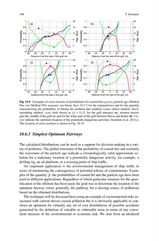
Fig. 10.9 Examples of cross-sections of probabilities for coastal hits (green), particle age (Method
IVa: red, Method IVb: magenta; see below Sect. 10.7.3 for the explanations) and for the quantity
characterizing the probability of hitting the northern and southern coasts (direct method: black;
smoothing method: cyan, both shown as ( ˆ
p + 1)/2: for the gulf entrance (a), western narrow
part (b), middle of the gulf (c) and for the wider part of the gulf between Narva and Kotka (d). Circles indicate the optimum location of the potentially dangerous activities (Soomere et al. 2011c).
The location of cross-sections is shown in Fig. 10.10
10.6.3 Simplest Optimum Fairways
The calculated distributions can be used as a support for decision-making in a variety of problems. The global minimum of the probability of coastal hits and similarly
the maximum of the particle age indicate a climatologically valid approximate solution for a stationary location of a potentially dangerous activity, for example, a
drilling rig, an oil platform, or a crossing point of ship traffic.
An important application is the environmental management of ship traffic in
terms of minimizing the consequences of potential release of contaminants. Examples of the quantity ˆ
p, the probabilities of coastal hit and the particle age have been
used in different applications. Regardless of which particular measure for the quantification of the offshore has been used, the goal was to determine the location of the
optimum fairway (more generally, the pathway for a moving source of pollution)
based on the obtained distributions.
The technique will be discussed here using an example of environmental risks associated with current-driven coastal pollution but it is obviously applicable to construct an optimum for virtually any set of cost distributions of possible accidents
generated by the definition of valuable or vulnerable areas in terms of any convenient measure of the environmental or economic risk. We start from an idealized
T. Soomere
Fig. 10.9 Examples of cross-sections of probabilities for coastal hits (green), particle age (Method
IVa: red, Method IVb: magenta; see below Sect. 10.7.3 for the explanations) and for the quantity
characterizing the probability of hitting the northern and southern coasts (direct method: black;
smoothing method: cyan, both shown as ( ˆ
p + 1)/2: for the gulf entrance (a), western narrow
part (b), middle of the gulf (c) and for the wider part of the gulf between Narva and Kotka (d). Circles indicate the optimum location of the potentially dangerous activities (Soomere et al. 2011c).
The location of cross-sections is shown in Fig. 10.10
10.6.3 Simplest Optimum Fairways
The calculated distributions can be used as a support for decision-making in a variety of problems. The global minimum of the probability of coastal hits and similarly
the maximum of the particle age indicate a climatologically valid approximate solution for a stationary location of a potentially dangerous activity, for example, a
drilling rig, an oil platform, or a crossing point of ship traffic.
An important application is the environmental management of ship traffic in
terms of minimizing the consequences of potential release of contaminants. Examples of the quantity ˆ
p, the probabilities of coastal hit and the particle age have been
used in different applications. Regardless of which particular measure for the quantification of the offshore has been used, the goal was to determine the location of the
optimum fairway (more generally, the pathway for a moving source of pollution)
based on the obtained distributions.
The technique will be discussed here using an example of environmental risks associated with current-driven coastal pollution but it is obviously applicable to construct an optimum for virtually any set of cost distributions of possible accidents
generated by the definition of valuable or vulnerable areas in terms of any convenient measure of the environmental or economic risk. We start from an idealized