

9 Statistics of Lagrangian Transport Reveals Hidden Features of Velocity Fields
287
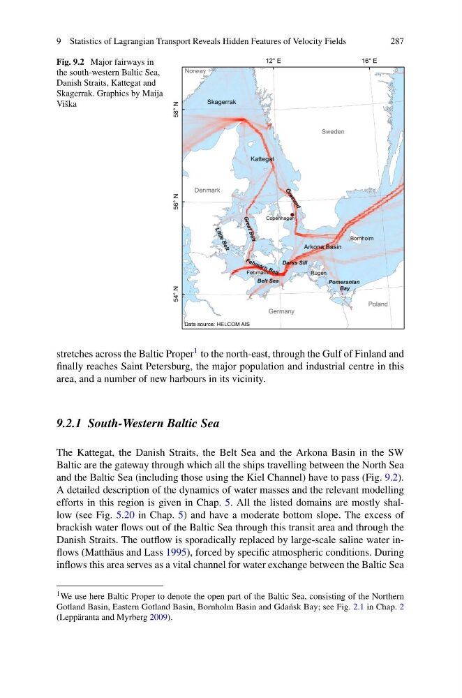
Fig. 9.2 Major fairways in
the south-western Baltic Sea,
Danish Straits, Kattegat and
Skagerrak. Graphics by Maija
Viška
stretches across the Baltic Proper 1 to the north-east, through the Gulf of Finland and
finally reaches Saint Petersburg, the major population and industrial centre in this
area, and a number of new harbours in its vicinity.
9.2.1 South-Western Baltic Sea
The Kattegat, the Danish Straits, the Belt Sea and the Arkona Basin in the SW
Baltic are the gateway through which all the ships travelling between the North Sea
and the Baltic Sea (including those using the Kiel Channel) have to pass (Fig. 9.2).
A detailed description of the dynamics of water masses and the relevant modelling
efforts in this region is given in Chap. 5. All the listed domains are mostly shallow (see Fig. 5.20 in Chap. 5) and have a moderate bottom slope. The excess of
brackish water flows out of the Baltic Sea through this transit area and through the
Danish Straits. The outflow is sporadically replaced by large-scale saline water inflows (Matthäus and Lass 1995), forced by specific atmospheric conditions. During
inflows this area serves as a vital channel for water exchange between the Baltic Sea
1 We use here Baltic Proper to denote the open part of the Baltic Sea, consisting of the Northern
Gotland Basin, Eastern Gotland Basin, Bornholm Basin and Gda´ nsk Bay; see Fig. 2.1 in Chap. 2
(Leppäranta and Myrberg 2009).
287
Fig. 9.2 Major fairways in
the south-western Baltic Sea,
Danish Straits, Kattegat and
Skagerrak. Graphics by Maija
Viška
stretches across the Baltic Proper 1 to the north-east, through the Gulf of Finland and
finally reaches Saint Petersburg, the major population and industrial centre in this
area, and a number of new harbours in its vicinity.
9.2.1 South-Western Baltic Sea
The Kattegat, the Danish Straits, the Belt Sea and the Arkona Basin in the SW
Baltic are the gateway through which all the ships travelling between the North Sea
and the Baltic Sea (including those using the Kiel Channel) have to pass (Fig. 9.2).
A detailed description of the dynamics of water masses and the relevant modelling
efforts in this region is given in Chap. 5. All the listed domains are mostly shallow (see Fig. 5.20 in Chap. 5) and have a moderate bottom slope. The excess of
brackish water flows out of the Baltic Sea through this transit area and through the
Danish Straits. The outflow is sporadically replaced by large-scale saline water inflows (Matthäus and Lass 1995), forced by specific atmospheric conditions. During
inflows this area serves as a vital channel for water exchange between the Baltic Sea
1 We use here Baltic Proper to denote the open part of the Baltic Sea, consisting of the Northern
Gotland Basin, Eastern Gotland Basin, Bornholm Basin and Gda´ nsk Bay; see Fig. 2.1 in Chap. 2
(Leppäranta and Myrberg 2009).