

To virtually reconstruct the vertical elevations, the pre-Ike absolute elevation of
each point was found, using a 2008 pre-Ike LIDAR dataset that was acquired from
the Texas Natural Resource Information System (TNRIS). The resolution of this
dataset was 1 m horizontally, 0.01 m vertically. This dataset allowed the topography and structure of the dune–swale structure to be viewed, prior to Ike’s
rearrangement of the sands.
However, after Ike hit, the absolute elevation had completely changed in the area (the
entire beach profile was approximately 0.75 m lower). A changing profile would
modify the base structure upon which the dune and swale vertical locations were fixed.
Thus, when using the LIDAR dataset, the absolute elevation of each of the points was
adjusted relative to a nearby fixed point at the base of each house (its concrete driveway,
or similar feature that presumably did not change in elevation pre- to post-storm). In the
field, survey equipment was then utilized to assess the vertical difference between the
same nearby fixed point and the surveyed points, so that the vertical distance could be
defined that the surface would have to change to approximate the pre-Ike absolute
elevation. The flags were then marked to denote this information. To double-check the
calculations of depth and height, several holes were also dug at the location of the swale
until the original surface had been hit. The vertical and horizontal match was quite
strong, with calculated depths less than 0.05 m off from actual field depths.
Once vertical and horizontal locations were marked in the field, backhoes and
tractors were used to reconstruct the pre-Ike topography. Sporobolus virginicus was
then planted at the base of the dunes, with P. amarum covering the rest of the dunes.
Spartina patens was planted in the swales. Over the next year, the beach profile also
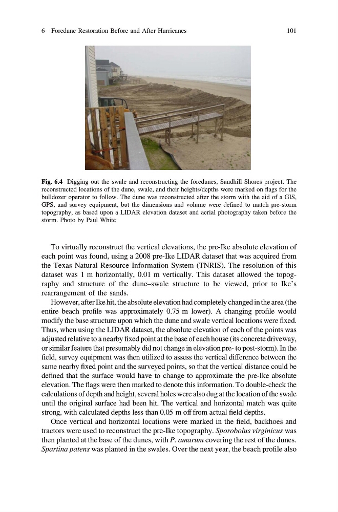
Fig. 6.4 Digging out the swale and reconstructing the foredunes, Sandhill Shores project. The
reconstructed locations of the dune, swale, and their heights/depths were marked on flags for the
bulldozer operator to follow. The dune was reconstructed after the storm with the aid of a GIS,
GPS, and survey equipment, but the dimensions and volume were defined to match pre-storm
topography, as based upon a LIDAR elevation dataset and aerial photography taken before the
storm. Photo by Paul White
6 Foredune Restoration Before and After Hurricanes
101
each point was found, using a 2008 pre-Ike LIDAR dataset that was acquired from
the Texas Natural Resource Information System (TNRIS). The resolution of this
dataset was 1 m horizontally, 0.01 m vertically. This dataset allowed the topography and structure of the dune–swale structure to be viewed, prior to Ike’s
rearrangement of the sands.
However, after Ike hit, the absolute elevation had completely changed in the area (the
entire beach profile was approximately 0.75 m lower). A changing profile would
modify the base structure upon which the dune and swale vertical locations were fixed.
Thus, when using the LIDAR dataset, the absolute elevation of each of the points was
adjusted relative to a nearby fixed point at the base of each house (its concrete driveway,
or similar feature that presumably did not change in elevation pre- to post-storm). In the
field, survey equipment was then utilized to assess the vertical difference between the
same nearby fixed point and the surveyed points, so that the vertical distance could be
defined that the surface would have to change to approximate the pre-Ike absolute
elevation. The flags were then marked to denote this information. To double-check the
calculations of depth and height, several holes were also dug at the location of the swale
until the original surface had been hit. The vertical and horizontal match was quite
strong, with calculated depths less than 0.05 m off from actual field depths.
Once vertical and horizontal locations were marked in the field, backhoes and
tractors were used to reconstruct the pre-Ike topography. Sporobolus virginicus was
then planted at the base of the dunes, with P. amarum covering the rest of the dunes.
Spartina patens was planted in the swales. Over the next year, the beach profile also
Fig. 6.4 Digging out the swale and reconstructing the foredunes, Sandhill Shores project. The
reconstructed locations of the dune, swale, and their heights/depths were marked on flags for the
bulldozer operator to follow. The dune was reconstructed after the storm with the aid of a GIS,
GPS, and survey equipment, but the dimensions and volume were defined to match pre-storm
topography, as based upon a LIDAR elevation dataset and aerial photography taken before the
storm. Photo by Paul White
6 Foredune Restoration Before and After Hurricanes
101