

roads with a large number of parking and petrol stations (vehicle emissions) etc.
Complicated combination of all factors defines and overall level of oil pollution and
the features of distribution/accumulation in various components of a given water
area (Ovsyaniy et al. 2001; Osadchaya 2010).
Oil and oil products, entering into marine environment by a variety ways are
sorbed on the particles of suspended matter, undergo the chemical and biochemical
transformation and, ultimately, pass from the water column to bottom sediments.
Accumulating all entering substances, the sediments promote their removal from
the water environment, participating thereby in self-cleaning process. At the same
time, an unstable weather conditions, relatively shallow depths of the water area
cause an intense mixing of water and bottom masses, creating, thereby, a threat of
secondary pollution of the marine environment. In this context, when assessing
long-term changes in water areas, determination of the content of pollutants in
bottom sediments has the advantage that the indicator is integrating in time and in
space (Osadchaya et al. 2004; Wilson et al. 2008; Mironov et al. 2009).
20.2 Study Area
Sevastopol region occupies the southwestern part of the Crimean Peninsula; its
coastline covers 158 km. Total square of regional marine area is about 379.5 km
2
and includes a series the bays (about 30) among which a leading position belongs to
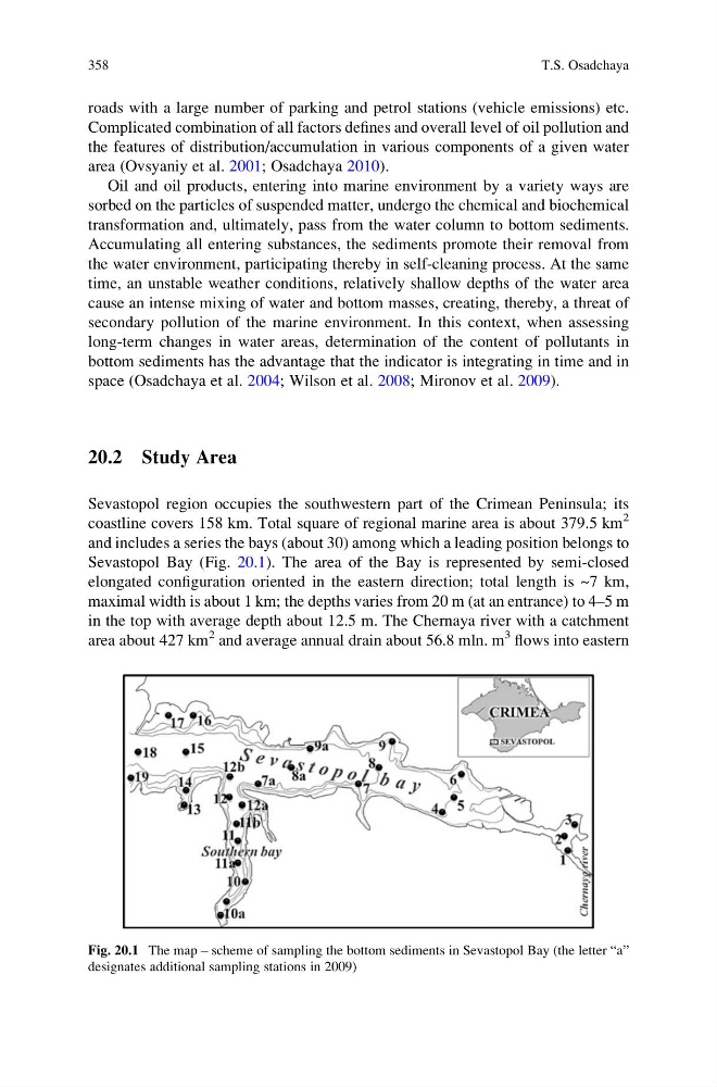
Sevastopol Bay (Fig. 20.1). The area of the Bay is represented by semi-closed
elongated configuration oriented in the eastern direction; total length is ~7 km,
maximal width is about 1 km; the depths varies from 20 m (at an entrance) to 4–5 m
in the top with average depth about 12.5 m. The Chernaya river with a catchment
area about 427 km
2 and average annual drain about 56.8 mln. m
3 flows into eastern
Fig. 20.1 The map – scheme of sampling the bottom sediments in Sevastopol Bay (the letter “a”
designates additional sampling stations in 2009)
358
T.S. Osadchaya
Complicated combination of all factors defines and overall level of oil pollution and
the features of distribution/accumulation in various components of a given water
area (Ovsyaniy et al. 2001; Osadchaya 2010).
Oil and oil products, entering into marine environment by a variety ways are
sorbed on the particles of suspended matter, undergo the chemical and biochemical
transformation and, ultimately, pass from the water column to bottom sediments.
Accumulating all entering substances, the sediments promote their removal from
the water environment, participating thereby in self-cleaning process. At the same
time, an unstable weather conditions, relatively shallow depths of the water area
cause an intense mixing of water and bottom masses, creating, thereby, a threat of
secondary pollution of the marine environment. In this context, when assessing
long-term changes in water areas, determination of the content of pollutants in
bottom sediments has the advantage that the indicator is integrating in time and in
space (Osadchaya et al. 2004; Wilson et al. 2008; Mironov et al. 2009).
20.2 Study Area
Sevastopol region occupies the southwestern part of the Crimean Peninsula; its
coastline covers 158 km. Total square of regional marine area is about 379.5 km
2
and includes a series the bays (about 30) among which a leading position belongs to
Sevastopol Bay (Fig. 20.1). The area of the Bay is represented by semi-closed
elongated configuration oriented in the eastern direction; total length is ~7 km,
maximal width is about 1 km; the depths varies from 20 m (at an entrance) to 4–5 m
in the top with average depth about 12.5 m. The Chernaya river with a catchment
area about 427 km
2 and average annual drain about 56.8 mln. m
3 flows into eastern
Fig. 20.1 The map – scheme of sampling the bottom sediments in Sevastopol Bay (the letter “a”
designates additional sampling stations in 2009)
358
T.S. Osadchaya