

5.3 Drainage Management
83
HHW =
NN +5.22 m
MLW =
NN -1.61 m
Ems
River dikes
NN +/- 0 m
12
10
8
6
4
2
-2
Elevaon [m]
Drainage canal
Distance [km]
0
35
Emden
Ems
Ley Bay
MHW =
NN +1.35 m
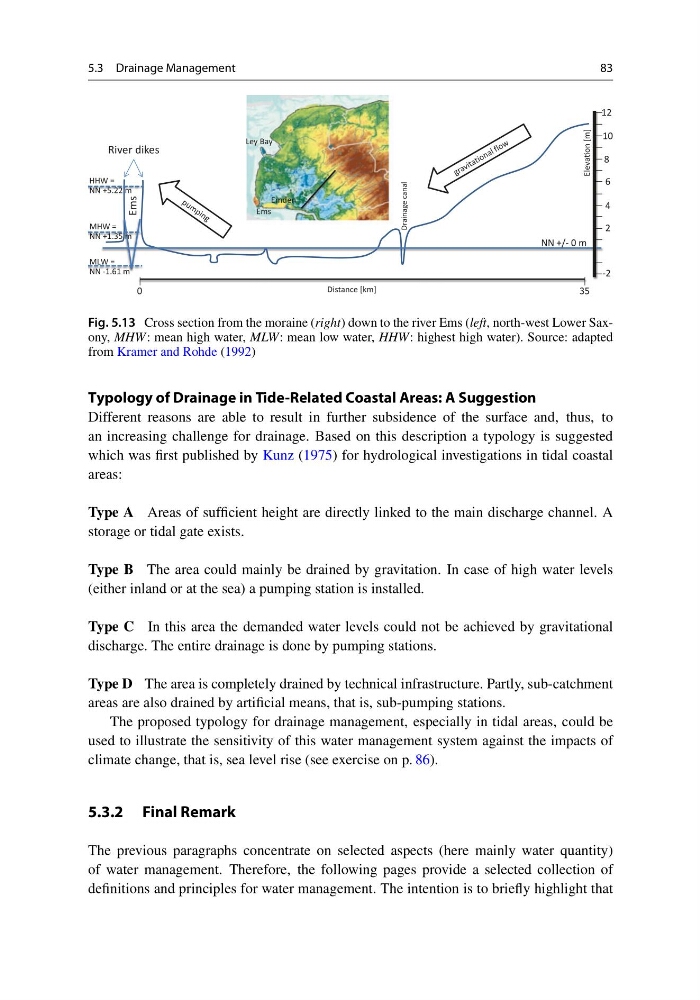
Fig. 5.13 Cross section from the moraine (right) down to the river Ems (left, north-west Lower Saxony, MHW: mean high water, MLW: mean low water, HHW: highest high water). Source: adapted
from Kramer and Rohde (1992)
Typology of Drainage in Tide-Related Coastal Areas: A Suggestion
Different reasons are able to result in further subsidence of the surface and, thus, to
an increasing challenge for drainage. Based on this description a typology is suggested
which was first published by Kunz (1975) for hydrological investigations in tidal coastal
areas:
Type A Areas of sufficient height are directly linked to the main discharge channel. A
storage or tidal gate exists.
Type B The area could mainly be drained by gravitation. In case of high water levels
(either inland or at the sea) a pumping station is installed.
Type C In this area the demanded water levels could not be achieved by gravitational
discharge. The entire drainage is done by pumping stations.
Type D The area is completely drained by technical infrastructure. Partly, sub-catchment
areas are also drained by artificial means, that is, sub-pumping stations.
The proposed typology for drainage management, especially in tidal areas, could be
used to illustrate the sensitivity of this water management system against the impacts of
climate change, that is, sea level rise (see exercise on p. 86).
5.3.2 Final Remark
The previous paragraphs concentrate on selected aspects (here mainly water quantity)
of water management. Therefore, the following pages provide a selected collection of
definitions and principles for water management. The intention is to briefly highlight that
83
HHW =
NN +5.22 m
MLW =
NN -1.61 m
Ems
River dikes
NN +/- 0 m
12
10
8
6
4
2
-2
Elevaon [m]
Drainage canal
Distance [km]
0
35
Emden
Ems
Ley Bay
MHW =
NN +1.35 m
Fig. 5.13 Cross section from the moraine (right) down to the river Ems (left, north-west Lower Saxony, MHW: mean high water, MLW: mean low water, HHW: highest high water). Source: adapted
from Kramer and Rohde (1992)
Typology of Drainage in Tide-Related Coastal Areas: A Suggestion
Different reasons are able to result in further subsidence of the surface and, thus, to
an increasing challenge for drainage. Based on this description a typology is suggested
which was first published by Kunz (1975) for hydrological investigations in tidal coastal
areas:
Type A Areas of sufficient height are directly linked to the main discharge channel. A
storage or tidal gate exists.
Type B The area could mainly be drained by gravitation. In case of high water levels
(either inland or at the sea) a pumping station is installed.
Type C In this area the demanded water levels could not be achieved by gravitational
discharge. The entire drainage is done by pumping stations.
Type D The area is completely drained by technical infrastructure. Partly, sub-catchment
areas are also drained by artificial means, that is, sub-pumping stations.
The proposed typology for drainage management, especially in tidal areas, could be
used to illustrate the sensitivity of this water management system against the impacts of
climate change, that is, sea level rise (see exercise on p. 86).
5.3.2 Final Remark
The previous paragraphs concentrate on selected aspects (here mainly water quantity)
of water management. Therefore, the following pages provide a selected collection of
definitions and principles for water management. The intention is to briefly highlight that