

54
4 Hydrology of (Shallow) Coastal Regions
Upstream
Downstream
+ mass density
driven flow
Tidal flow
High tide flow
Low tide flow
t 1
t 2
t 3
t 4
t 5
t 1
t 2
t 3
t 4
t 5
= resulting flow
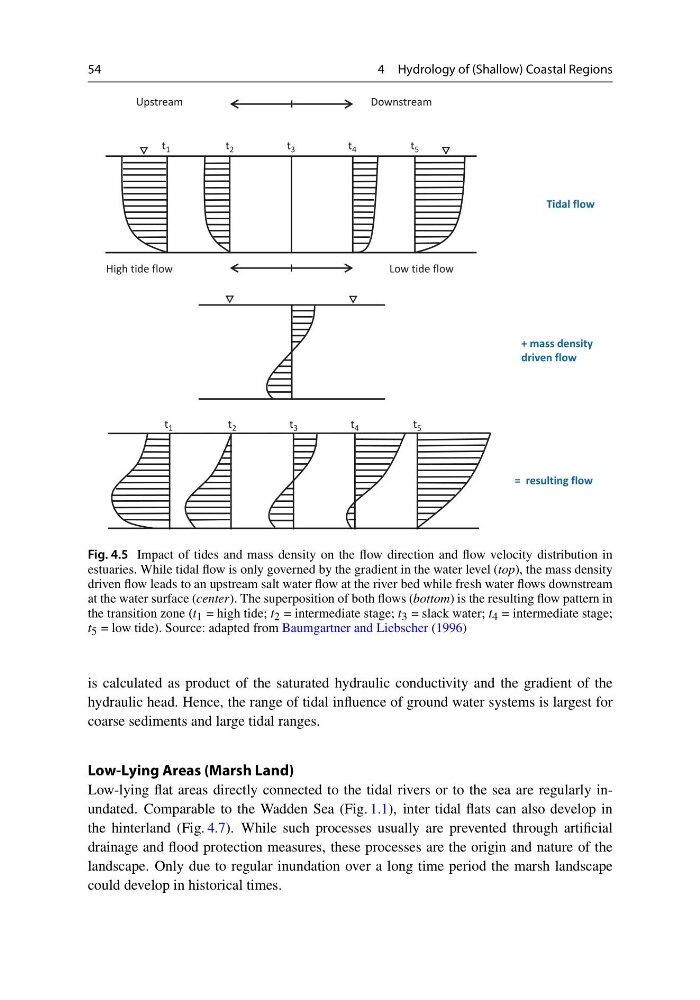
Fig. 4.5 Impact of tides and mass density on the flow direction and flow velocity distribution in
estuaries. While tidal flow is only governed by the gradient in the water level (top), the mass density
driven flow leads to an upstream salt water flow at the river bed while fresh water flows downstream
at the water surface (center). The superposition of both flows (bottom) is the resulting flow pattern in
the transition zone (t 1 = high tide; t 2 = intermediate stage; t 3 = slack water; t 4 = intermediate stage;
t 5 = low tide). Source: adapted from Baumgartner and Liebscher (1996)
is calculated as product of the saturated hydraulic conductivity and the gradient of the
hydraulic head. Hence, the range of tidal influence of ground water systems is largest for
coarse sediments and large tidal ranges.
Low-Lying Areas (Marsh Land)
Low-lying flat areas directly connected to the tidal rivers or to the sea are regularly inundated. Comparable to the Wadden Sea (Fig. 1.1), inter tidal flats can also develop in
the hinterland (Fig. 4.7). While such processes usually are prevented through artificial
drainage and flood protection measures, these processes are the origin and nature of the
landscape. Only due to regular inundation over a long time period the marsh landscape
could develop in historical times.
4 Hydrology of (Shallow) Coastal Regions
Upstream
Downstream
+ mass density
driven flow
Tidal flow
High tide flow
Low tide flow
t 1
t 2
t 3
t 4
t 5
t 1
t 2
t 3
t 4
t 5
= resulting flow
Fig. 4.5 Impact of tides and mass density on the flow direction and flow velocity distribution in
estuaries. While tidal flow is only governed by the gradient in the water level (top), the mass density
driven flow leads to an upstream salt water flow at the river bed while fresh water flows downstream
at the water surface (center). The superposition of both flows (bottom) is the resulting flow pattern in
the transition zone (t 1 = high tide; t 2 = intermediate stage; t 3 = slack water; t 4 = intermediate stage;
t 5 = low tide). Source: adapted from Baumgartner and Liebscher (1996)
is calculated as product of the saturated hydraulic conductivity and the gradient of the
hydraulic head. Hence, the range of tidal influence of ground water systems is largest for
coarse sediments and large tidal ranges.
Low-Lying Areas (Marsh Land)
Low-lying flat areas directly connected to the tidal rivers or to the sea are regularly inundated. Comparable to the Wadden Sea (Fig. 1.1), inter tidal flats can also develop in
the hinterland (Fig. 4.7). While such processes usually are prevented through artificial
drainage and flood protection measures, these processes are the origin and nature of the
landscape. Only due to regular inundation over a long time period the marsh landscape
could develop in historical times.