

8.2 Problem 1: Eroding Coastal Stretch
185
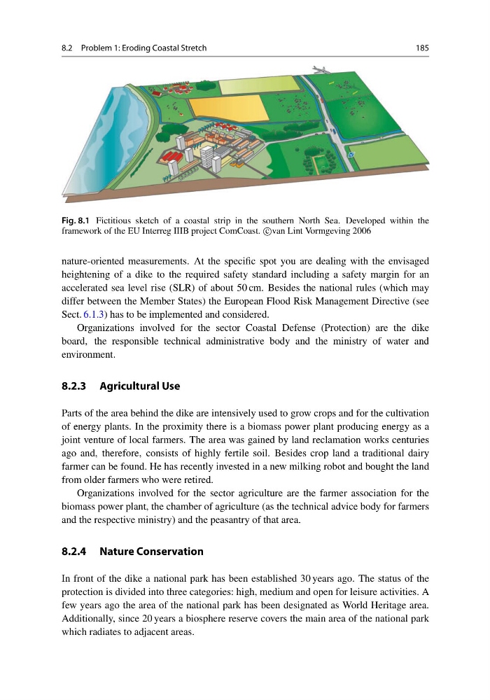
Fig. 8.1 Fictitious sketch of a coastal strip in the southern North Sea. Developed within the
framework of the EU Interreg IIIB project ComCoast. c
van Lint Vormgeving 2006
nature-oriented measurements. At the specific spot you are dealing with the envisaged
heightening of a dike to the required safety standard including a safety margin for an
accelerated sea level rise (SLR) of about 50 cm. Besides the national rules (which may
differ between the Member States) the European Flood Risk Management Directive (see
Sect. 6.1.3) has to be implemented and considered.
Organizations involved for the sector Coastal Defense (Protection) are the dike
board, the responsible technical administrative body and the ministry of water and
environment.
8.2.3 Agricultural Use
Parts of the area behind the dike are intensively used to grow crops and for the cultivation
of energy plants. In the proximity there is a biomass power plant producing energy as a
joint venture of local farmers. The area was gained by land reclamation works centuries
ago and, therefore, consists of highly fertile soil. Besides crop land a traditional dairy
farmer can be found. He has recently invested in a new milking robot and bought the land
from older farmers who were retired.
Organizations involved for the sector agriculture are the farmer association for the
biomass power plant, the chamber of agriculture (as the technical advice body for farmers
and the respective ministry) and the peasantry of that area.
8.2.4 Nature Conservation
In front of the dike a national park has been established 30 years ago. The status of the
protection is divided into three categories: high, medium and open for leisure activities. A
few years ago the area of the national park has been designated as World Heritage area.
Additionally, since 20 years a biosphere reserve covers the main area of the national park
which radiates to adjacent areas.
185
Fig. 8.1 Fictitious sketch of a coastal strip in the southern North Sea. Developed within the
framework of the EU Interreg IIIB project ComCoast. c
van Lint Vormgeving 2006
nature-oriented measurements. At the specific spot you are dealing with the envisaged
heightening of a dike to the required safety standard including a safety margin for an
accelerated sea level rise (SLR) of about 50 cm. Besides the national rules (which may
differ between the Member States) the European Flood Risk Management Directive (see
Sect. 6.1.3) has to be implemented and considered.
Organizations involved for the sector Coastal Defense (Protection) are the dike
board, the responsible technical administrative body and the ministry of water and
environment.
8.2.3 Agricultural Use
Parts of the area behind the dike are intensively used to grow crops and for the cultivation
of energy plants. In the proximity there is a biomass power plant producing energy as a
joint venture of local farmers. The area was gained by land reclamation works centuries
ago and, therefore, consists of highly fertile soil. Besides crop land a traditional dairy
farmer can be found. He has recently invested in a new milking robot and bought the land
from older farmers who were retired.
Organizations involved for the sector agriculture are the farmer association for the
biomass power plant, the chamber of agriculture (as the technical advice body for farmers
and the respective ministry) and the peasantry of that area.
8.2.4 Nature Conservation
In front of the dike a national park has been established 30 years ago. The status of the
protection is divided into three categories: high, medium and open for leisure activities. A
few years ago the area of the national park has been designated as World Heritage area.
Additionally, since 20 years a biosphere reserve covers the main area of the national park
which radiates to adjacent areas.