

152
6 Prospects: Approaches of Integrated Management
Tidal Gate
Beckumer
Siel
Jade Bay
Tidal
Gate
Käseburger
Siel
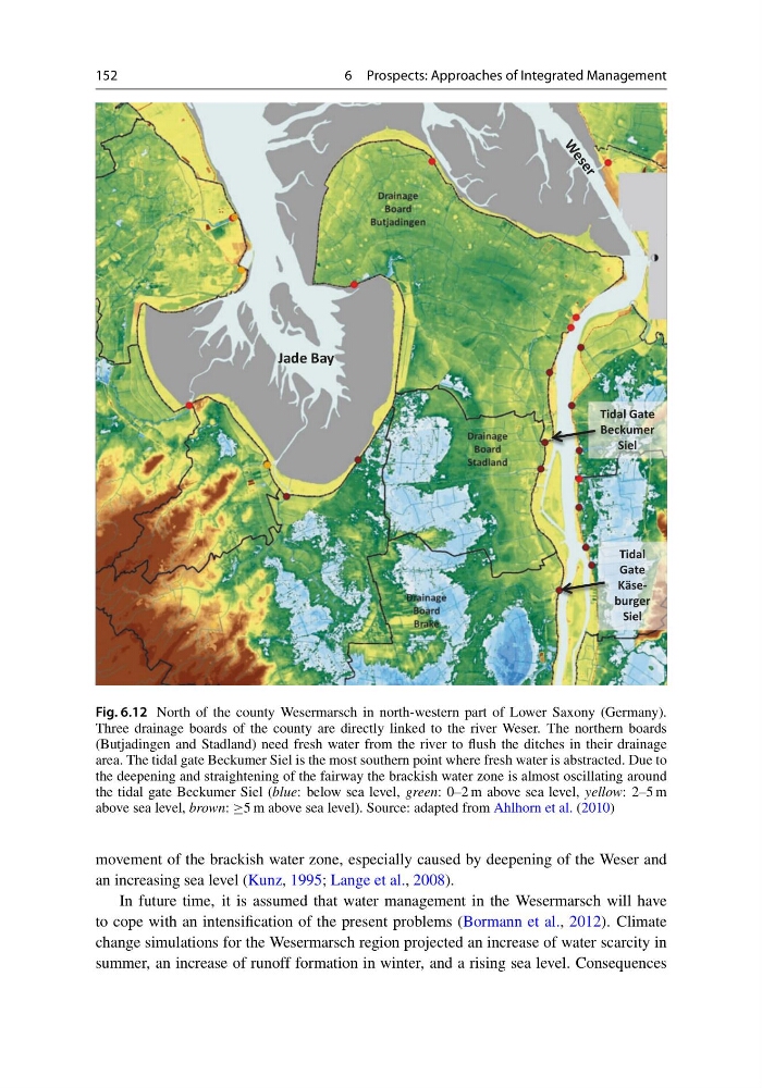
Fig. 6.12 North of the county Wesermarsch in north-western part of Lower Saxony (Germany).
Three drainage boards of the county are directly linked to the river Weser. The northern boards
(Butjadingen and Stadland) need fresh water from the river to flush the ditches in their drainage
area. The tidal gate Beckumer Siel is the most southern point where fresh water is abstracted. Due to
the deepening and straightening of the fairway the brackish water zone is almost oscillating around
the tidal gate Beckumer Siel (blue: below sea level, green: 0–2 m above sea level, yellow: 2–5 m
above sea level, brown: ≥5 m above sea level). Source: adapted from Ahlhorn et al. (2010)
movement of the brackish water zone, especially caused by deepening of the Weser and
an increasing sea level (Kunz, 1995; Lange et al., 2008).
In future time, it is assumed that water management in the Wesermarsch will have
to cope with an intensification of the present problems (Bormann et al., 2012). Climate
change simulations for the Wesermarsch region projected an increase of water scarcity in
summer, an increase of runoff formation in winter, and a rising sea level. Consequences
6 Prospects: Approaches of Integrated Management
Tidal Gate
Beckumer
Siel
Jade Bay
Tidal
Gate
Käseburger
Siel
Fig. 6.12 North of the county Wesermarsch in north-western part of Lower Saxony (Germany).
Three drainage boards of the county are directly linked to the river Weser. The northern boards
(Butjadingen and Stadland) need fresh water from the river to flush the ditches in their drainage
area. The tidal gate Beckumer Siel is the most southern point where fresh water is abstracted. Due to
the deepening and straightening of the fairway the brackish water zone is almost oscillating around
the tidal gate Beckumer Siel (blue: below sea level, green: 0–2 m above sea level, yellow: 2–5 m
above sea level, brown: ≥5 m above sea level). Source: adapted from Ahlhorn et al. (2010)
movement of the brackish water zone, especially caused by deepening of the Weser and
an increasing sea level (Kunz, 1995; Lange et al., 2008).
In future time, it is assumed that water management in the Wesermarsch will have
to cope with an intensification of the present problems (Bormann et al., 2012). Climate
change simulations for the Wesermarsch region projected an increase of water scarcity in
summer, an increase of runoff formation in winter, and a rising sea level. Consequences