

150
6 Prospects: Approaches of Integrated Management
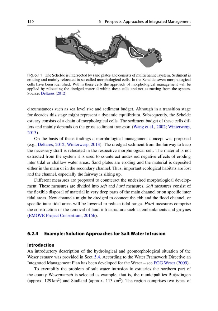
Fig. 6.11 The Schelde is intersected by sand plates and consists of multichannel system. Sediment is
eroding and mainly relocated in so-called morphological cells. In the Schelde seven morphological
cells have been identified. Within these cells the approach of morphological management will be
applied by relocating the dredged material within these cells and not extracting from the system.
Source: Deltares (2012)
circumstances such as sea level rise and sediment budget. Although in a transition stage
for decades this stage might represent a dynamic equilibrium. Subsequently, the Schelde
estuary consists of a chain of morphological cells. The sediment budget of these cells differs and mainly depends on the gross sediment transport (Wang et al., 2002; Winterwerp,
2013).
On the basis of these findings a morphological management concept was proposed
(e.g., Deltares, 2012; Winterwerp, 2013). The dredged sediment from the fairway to keep
the necessary draft is relocated in the respective morphological cell. The material is not
extracted from the system it is used to counteract undesired negative effects of eroding
inter tidal or shallow water areas. Sand plates are eroding and the material is deposited
either in the main or in the secondary channel. Thus, important ecological habitats are lost
and the channel, especially the fairway is silting up.
Different measures are proposed to counteract the undesired morphological development. These measures are divided into soft and hard measures. Soft measures consist of
the flexible disposal of material in very deep parts of the main channel or on specific inter
tidal areas. New channels might be dredged to connect the ebb and the flood channel, or
specific inter tidal areas will be lowered to reduce tidal range. Hard measures comprise
the construction or the removal of hard infrastructure such as embankments and groynes
(EMOVE Project Consortium, 2015b).
6.2.4 Example: Solution Approaches for Salt Water Intrusion
Introduction
An introductory description of the hydrological and geomorphological situation of the
Weser estuary was provided in Sect. 5.4. According to the Water Framework Directive an
Integrated Management Plan has been developed for the Weser – see FGG Weser (2009).
To exemplify the problem of salt water intrusion in estuaries the northern part of
the county Wesermarsch is selected as example, that is, the municipalities Butjadingen
(approx. 129 km 2 ) and Stadland (approx. 113 km 2 ). The region comprises two types of
6 Prospects: Approaches of Integrated Management
Fig. 6.11 The Schelde is intersected by sand plates and consists of multichannel system. Sediment is
eroding and mainly relocated in so-called morphological cells. In the Schelde seven morphological
cells have been identified. Within these cells the approach of morphological management will be
applied by relocating the dredged material within these cells and not extracting from the system.
Source: Deltares (2012)
circumstances such as sea level rise and sediment budget. Although in a transition stage
for decades this stage might represent a dynamic equilibrium. Subsequently, the Schelde
estuary consists of a chain of morphological cells. The sediment budget of these cells differs and mainly depends on the gross sediment transport (Wang et al., 2002; Winterwerp,
2013).
On the basis of these findings a morphological management concept was proposed
(e.g., Deltares, 2012; Winterwerp, 2013). The dredged sediment from the fairway to keep
the necessary draft is relocated in the respective morphological cell. The material is not
extracted from the system it is used to counteract undesired negative effects of eroding
inter tidal or shallow water areas. Sand plates are eroding and the material is deposited
either in the main or in the secondary channel. Thus, important ecological habitats are lost
and the channel, especially the fairway is silting up.
Different measures are proposed to counteract the undesired morphological development. These measures are divided into soft and hard measures. Soft measures consist of
the flexible disposal of material in very deep parts of the main channel or on specific inter
tidal areas. New channels might be dredged to connect the ebb and the flood channel, or
specific inter tidal areas will be lowered to reduce tidal range. Hard measures comprise
the construction or the removal of hard infrastructure such as embankments and groynes
(EMOVE Project Consortium, 2015b).
6.2.4 Example: Solution Approaches for Salt Water Intrusion
Introduction
An introductory description of the hydrological and geomorphological situation of the
Weser estuary was provided in Sect. 5.4. According to the Water Framework Directive an
Integrated Management Plan has been developed for the Weser – see FGG Weser (2009).
To exemplify the problem of salt water intrusion in estuaries the northern part of
the county Wesermarsch is selected as example, that is, the municipalities Butjadingen
(approx. 129 km 2 ) and Stadland (approx. 113 km 2 ). The region comprises two types of