

Lake Basin Characteristics and Morphometry
7
F
B
w
Z
-.J
L
...
I.U
CJ)
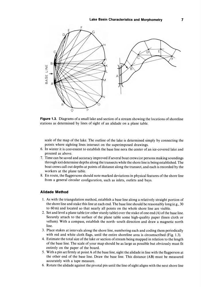
Figure 1.3. Diagrams of a small lake and section of a stream showing the locations of shoreline
stations as determined by lines of sight of an alidade on a plane table.
scale of the map of the lake. The outline of the lake is determined simply by connecting the
points where sighting lines intersect on the superimposed drawings.
6. In winter it is convenient to establish the base line nera the center of an ice-covered lake and
proceed as above.
7. Time can be saved and accuracy improved if several boat crews (or persons making soundings
through ice) determine depths along the transects while the shore line is being established. The
boat crews call out depths at points of distance along the transect, and each is recorded by the
workers at the plane table.
8. En route, the flagpersons should note marked deviations in physical features of the shore line
from a general circular configuration, such as inlets, outlets and bays.
Alidade Method
1. As with the triangulation method, establish a base line along a relatively straight portion of
the shore line and stake this line at each end. The base line should be reasonably long (e.g., 30
to 60 m) and located so that nearly all points on the whole shore line are visible.
2. Set and level a plane table (or other sturdy table) over the stake of one end (A) of the base line.
Securely attach to the surface of the plane table some high-quality paper (linen cloth or
vellum). With a compass, establish the north-south direction and draw a magnetic north
line.
3. Place stakes at intervals along the shore line, numbering each and coding them periodically
with red and white cloth flags, until the entire shoreline area is circumscribed (Fig. 1.3).
4. Estimate the total size of the lake or section of stream being mapped in relation to the length
of the base line. The scale of your map should be as large as possible but obviously must fit
entirely on the paper of the board.
5. With a pin set firmly at point A of the base line, sight the alidade in line with the flagperson at
the other end of the base line. Draw the base line. This distance (AB) must be measured
accurately with a tape measure.
6. Rotate the alidade against the pivotal pin until the line of sight aligns with the next shore line
7
F
B
w
Z
-.J
L
...
I.U
CJ)
Figure 1.3. Diagrams of a small lake and section of a stream showing the locations of shoreline
stations as determined by lines of sight of an alidade on a plane table.
scale of the map of the lake. The outline of the lake is determined simply by connecting the
points where sighting lines intersect on the superimposed drawings.
6. In winter it is convenient to establish the base line nera the center of an ice-covered lake and
proceed as above.
7. Time can be saved and accuracy improved if several boat crews (or persons making soundings
through ice) determine depths along the transects while the shore line is being established. The
boat crews call out depths at points of distance along the transect, and each is recorded by the
workers at the plane table.
8. En route, the flagpersons should note marked deviations in physical features of the shore line
from a general circular configuration, such as inlets, outlets and bays.
Alidade Method
1. As with the triangulation method, establish a base line along a relatively straight portion of
the shore line and stake this line at each end. The base line should be reasonably long (e.g., 30
to 60 m) and located so that nearly all points on the whole shore line are visible.
2. Set and level a plane table (or other sturdy table) over the stake of one end (A) of the base line.
Securely attach to the surface of the plane table some high-quality paper (linen cloth or
vellum). With a compass, establish the north-south direction and draw a magnetic north
line.
3. Place stakes at intervals along the shore line, numbering each and coding them periodically
with red and white cloth flags, until the entire shoreline area is circumscribed (Fig. 1.3).
4. Estimate the total size of the lake or section of stream being mapped in relation to the length
of the base line. The scale of your map should be as large as possible but obviously must fit
entirely on the paper of the board.
5. With a pin set firmly at point A of the base line, sight the alidade in line with the flagperson at
the other end of the base line. Draw the base line. This distance (AB) must be measured
accurately with a tape measure.
6. Rotate the alidade against the pivotal pin until the line of sight aligns with the next shore line