

4
Exercise 1
(J)
a..
I
(J)
Z
~
o I(J)
n:::
UJ
~
:r
~
0:
o
Z
8
7
6
. . A 1 I 1
~
2!!.
WEST
5 4
RANGES
3 2 1 1 2
EAST
3 4 5 8
7 8
1 ht Standa r d
le i Norlh
Paral
~
-
Base lin e
:r
....
::l
o
(f)
~ J
'~
3~1
~
~I
~
..!.!
1
6
7
18
19
30
31
~
J
J
I
1st Guide
Mer id ian We s t
~- I
I AL
P.o I NT
I I
I
1st Gui de
Mer idian Ealt
P rinici ple
Me ri d ia n
-
-
1 -
-
tat
Par
2n
Standard
allel Soulh
d Standard
e lle l South
Par
TOWNSHIPS
UNITED STATES
CANADA
5
4
3 2 1
31 32 33 3 4 3S 36
8
9 10 11 12
30 29 28 2 7 26 25
17 16 IS 14 13
19 20 2 1 22 23 24
20 21 22 23 24
18 17 16 IS 14 13
29 28 27 26 2S
7 8
9 10 11 12
32 33 34 3S 36
6
5 4 3 2 1
SECTIONS
13 14 IS 16
~ 11 10 9
5 6 7 8 I~
4 3 2 1
LECAl ~USDIVS I ONS
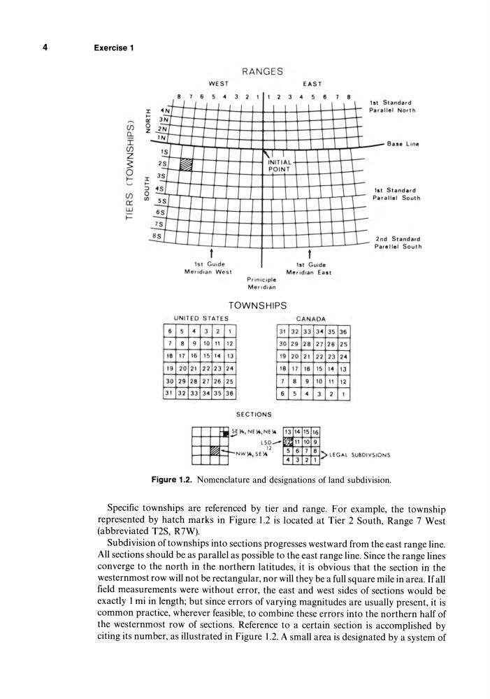
Figure 1.2. Nomenclature and designations of land subdivision.
Specific townships are referenced by tier and range. For example, the township
represented by hatch marks in Figure 1.2 is located at Tier 2 South, Range 7 West
(abbreviated T2S, R7W).
Subdivision of townships into sections progresses westward from the east range line.
All sections should be as parallel as possible to the east range line. Since the range lines
converge to the north in the northern latitudes, it is obvious that the section in the
westernmost row will not be rectangular, nor will they be a full square mile in area. If all
field measurements were without error, the east and west sides of sections would be
exactly 1 mi in length; but since errors of varying magnitudes are usually present, it is
common practice, wherever feasible, to combine these errors into the northern half of
the westernmost row of sections. Reference to a certain section is accomplished by
citing its number, as illustrated in Figure 1.2. A small area is designated by a system of
Exercise 1
(J)
a..
I
(J)
Z
~
o I(J)
n:::
UJ
~
:r
~
0:
o
Z
8
7
6
. . A 1 I 1
~
2!!.
WEST
5 4
RANGES
3 2 1 1 2
EAST
3 4 5 8
7 8
1 ht Standa r d
le i Norlh
Paral
~
-
Base lin e
:r
....
::l
o
(f)
~ J
'~
3~1
~
~I
~
..!.!
1
6
7
18
19
30
31
~
J
J
I
1st Guide
Mer id ian We s t
~- I
I AL
P.o I NT
I I
I
1st Gui de
Mer idian Ealt
P rinici ple
Me ri d ia n
-
-
1 -
-
tat
Par
2n
Standard
allel Soulh
d Standard
e lle l South
Par
TOWNSHIPS
UNITED STATES
CANADA
5
4
3 2 1
31 32 33 3 4 3S 36
8
9 10 11 12
30 29 28 2 7 26 25
17 16 IS 14 13
19 20 2 1 22 23 24
20 21 22 23 24
18 17 16 IS 14 13
29 28 27 26 2S
7 8
9 10 11 12
32 33 34 3S 36
6
5 4 3 2 1
SECTIONS
13 14 IS 16
~ 11 10 9
5 6 7 8 I~
4 3 2 1
LECAl ~USDIVS I ONS
Figure 1.2. Nomenclature and designations of land subdivision.
Specific townships are referenced by tier and range. For example, the township
represented by hatch marks in Figure 1.2 is located at Tier 2 South, Range 7 West
(abbreviated T2S, R7W).
Subdivision of townships into sections progresses westward from the east range line.
All sections should be as parallel as possible to the east range line. Since the range lines
converge to the north in the northern latitudes, it is obvious that the section in the
westernmost row will not be rectangular, nor will they be a full square mile in area. If all
field measurements were without error, the east and west sides of sections would be
exactly 1 mi in length; but since errors of varying magnitudes are usually present, it is
common practice, wherever feasible, to combine these errors into the northern half of
the westernmost row of sections. Reference to a certain section is accomplished by
citing its number, as illustrated in Figure 1.2. A small area is designated by a system of