

2
Exercise 1
they are imaginary planes that bisect the earth, and, in this special case, these planes
also bisect the polar axis. The equatorial plane bisects the earth normal (i.e.,
perpendicular) to the polar axis; hence, the equator is a great circle. Parallels oflatitude
other than the equator are not great circles but may be considered to be a series of
equally spaced planes parallel to the equatorial plane. The center of the earth is the
point of origin for the angular designations given to both latitudes and longitudes.
Longitudes are described as west or east of any selected meridian, which is called a
primary meridian. The primary meridian most commonly used is the one passing
through the observatory at Greenwich, England. Longitudes never exceed 180° east or
180° west of the primary meridian. Longitudes are true north~south lines; thus, no two
north~south lines are exactly parallel.
The direction oflines may be expressed as bearings and azimuths. Both are measured
in terms of degrees, minutes, and seconds of arc from a selected line of reference or
meridian. Azimuths are measured clockwise through 360°, starting from the reference
meridian. They may be referred to as either the north or south point, but never both on
the same survey. Bearings are measured either clockwise or counterclockwise in
quadrants and never exceed 90°.
Bearings are true, magnetic, or assumed, depending on the status of the reference line
used. When the reference is a geographic meridian, the bearings or azimuths are true.
When the reference line is arbitrarily selected for the immediate purpose of the survey,
the bearings or azimuths are assumed. When the bearings or azimuths are referred to a
magnetic north (compass) line they are magnetic. The relationships between true and
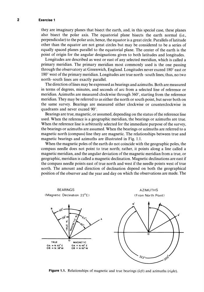
magnetic bearings and azimuths are illustrated in Fig. 1.1.
When the magnetic poles of the earth do not coincide with the geographic poles, the
compass needle does not point to true north; rather, it points along a line called a
magnetic meridian, and the angular deviation of the magnetic meridian from a true, or
geographic, meridian is called a magnetic declination. Magnetic declinations are east if
the compass needle points east of true north and west if the needle points west of true
north. The amount and direction of declination depend on both the geographical
position of the observer and the year and day on which the observations are made. The
BEARINGS
(Magnetic Declination 22°E)
TRUE
OA = N 62 0 E
08 = N 3lfW
MAGNETIC
OA = N 40· E
08 = N 60·W
A
AZIMUTHS
(From North Pomt)
Figure 1.1. Relationships of magnetic and true bearings (left) and azimuths (right).
Exercise 1
they are imaginary planes that bisect the earth, and, in this special case, these planes
also bisect the polar axis. The equatorial plane bisects the earth normal (i.e.,
perpendicular) to the polar axis; hence, the equator is a great circle. Parallels oflatitude
other than the equator are not great circles but may be considered to be a series of
equally spaced planes parallel to the equatorial plane. The center of the earth is the
point of origin for the angular designations given to both latitudes and longitudes.
Longitudes are described as west or east of any selected meridian, which is called a
primary meridian. The primary meridian most commonly used is the one passing
through the observatory at Greenwich, England. Longitudes never exceed 180° east or
180° west of the primary meridian. Longitudes are true north~south lines; thus, no two
north~south lines are exactly parallel.
The direction oflines may be expressed as bearings and azimuths. Both are measured
in terms of degrees, minutes, and seconds of arc from a selected line of reference or
meridian. Azimuths are measured clockwise through 360°, starting from the reference
meridian. They may be referred to as either the north or south point, but never both on
the same survey. Bearings are measured either clockwise or counterclockwise in
quadrants and never exceed 90°.
Bearings are true, magnetic, or assumed, depending on the status of the reference line
used. When the reference is a geographic meridian, the bearings or azimuths are true.
When the reference line is arbitrarily selected for the immediate purpose of the survey,
the bearings or azimuths are assumed. When the bearings or azimuths are referred to a
magnetic north (compass) line they are magnetic. The relationships between true and
magnetic bearings and azimuths are illustrated in Fig. 1.1.
When the magnetic poles of the earth do not coincide with the geographic poles, the
compass needle does not point to true north; rather, it points along a line called a
magnetic meridian, and the angular deviation of the magnetic meridian from a true, or
geographic, meridian is called a magnetic declination. Magnetic declinations are east if
the compass needle points east of true north and west if the needle points west of true
north. The amount and direction of declination depend on both the geographical
position of the observer and the year and day on which the observations are made. The
BEARINGS
(Magnetic Declination 22°E)
TRUE
OA = N 62 0 E
08 = N 3lfW
MAGNETIC
OA = N 40· E
08 = N 60·W
A
AZIMUTHS
(From North Pomt)
Figure 1.1. Relationships of magnetic and true bearings (left) and azimuths (right).