

78
N.M. Mattikalli and E.T. Engman
c:: . . ~
/
A Values 7
Land-use! cover
Classification
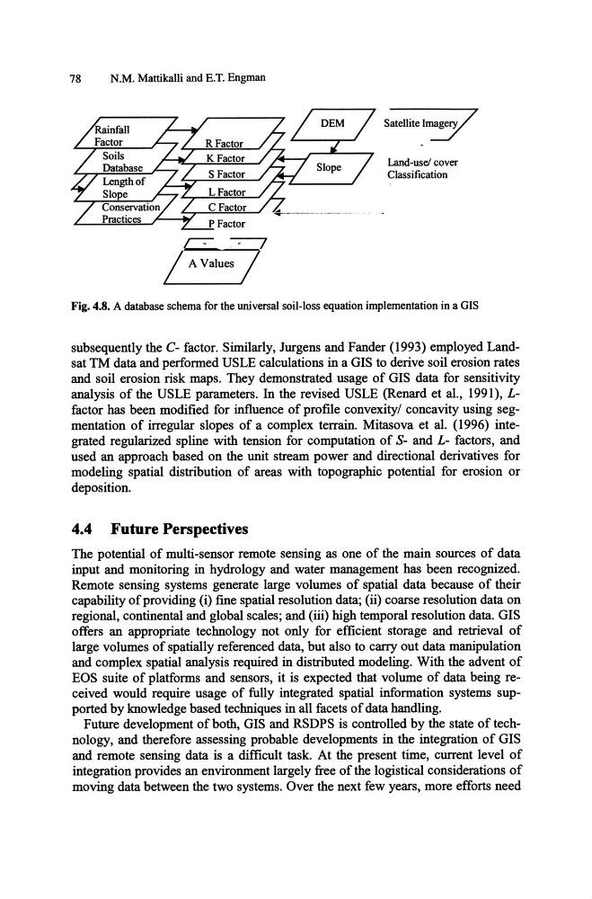
Fig. 4.8. A database schema for the universal soil-loss equation implementation in a GIS
subsequently the C- factor. Similarly, Jurgens and Fander (1993) employed Landsat TM data and performed USLE calculations in a GIS to derive soil erosion rates
and soil erosion risk maps. They demonstrated usage of GIS data for sensitivity
analysis of the USLE parameters. In the revised USLE (Renard et al., 1991), Lfactor has been modified for influence of profile convexity/ concavity using segmentation of irregular slopes of a complex terrain. Mitasova et al. (1996) integrated regularized spline with tension for computation of S- and L- factors, and
used an approach based on the unit stream power and directional derivatives for
modeling spatial distribution of areas with topographic potential for erosion or
deposition.
4.4 Future Perspectives
The potential of multi-sensor remote sensing as one of the main sources of data
input and monitoring in hydrology and water management has been recognized.
Remote sensing systems generate large volumes of spatial data because of their
capability of providing (i) fine spatial resolution data; (ii) coarse resolution data on
regional, continental and global scales; and (iii) high temporal resolution data. GIS
offers an appropriate technology not only for efficient storage and retrieval of
large volumes of spatially referenced data, but also to carry out data manipulation
and complex spatial analysis required in distributed modeling. With the advent of
EOS suite of platforms and sensors, it is expected that volume of data being received would require usage of fully integrated spatial information systems supported by knowledge based techniques in all facets of data handling.
Future development of both, GIS and RSDPS is controlled by the state of technology, and therefore assessing probable developments in the integration of GIS
and remote sensing data is a difficult task. At the present time, current level of
integration provides an environment largely free of the logistical considerations of
moving data between the two systems. Over the next few years, more efforts need
N.M. Mattikalli and E.T. Engman
c:: . . ~
/
A Values 7
Land-use! cover
Classification
Fig. 4.8. A database schema for the universal soil-loss equation implementation in a GIS
subsequently the C- factor. Similarly, Jurgens and Fander (1993) employed Landsat TM data and performed USLE calculations in a GIS to derive soil erosion rates
and soil erosion risk maps. They demonstrated usage of GIS data for sensitivity
analysis of the USLE parameters. In the revised USLE (Renard et al., 1991), Lfactor has been modified for influence of profile convexity/ concavity using segmentation of irregular slopes of a complex terrain. Mitasova et al. (1996) integrated regularized spline with tension for computation of S- and L- factors, and
used an approach based on the unit stream power and directional derivatives for
modeling spatial distribution of areas with topographic potential for erosion or
deposition.
4.4 Future Perspectives
The potential of multi-sensor remote sensing as one of the main sources of data
input and monitoring in hydrology and water management has been recognized.
Remote sensing systems generate large volumes of spatial data because of their
capability of providing (i) fine spatial resolution data; (ii) coarse resolution data on
regional, continental and global scales; and (iii) high temporal resolution data. GIS
offers an appropriate technology not only for efficient storage and retrieval of
large volumes of spatially referenced data, but also to carry out data manipulation
and complex spatial analysis required in distributed modeling. With the advent of
EOS suite of platforms and sensors, it is expected that volume of data being received would require usage of fully integrated spatial information systems supported by knowledge based techniques in all facets of data handling.
Future development of both, GIS and RSDPS is controlled by the state of technology, and therefore assessing probable developments in the integration of GIS
and remote sensing data is a difficult task. At the present time, current level of
integration provides an environment largely free of the logistical considerations of
moving data between the two systems. Over the next few years, more efforts need