

4 Integration of Remotely Sensed Data into Geographical Information Systems
75
4.3.4
Modeling Watershed Runoff
Historically, runoff modeling at the river basin scale has lumped rainfall, infiltration and other hydraulic parameters to apply everywhere in the basin. With the
advent of distributed modeling, a basin is subdivided into computational elements
at a smaller scale. A distributed simulation model allows a user to simulate spatially variable parameters without lumping. However, setting up such a model
with spatially distributed data and parameters is a time consuming and laborious
task. If a GIS is integrated with the model these chores become much easier and
often transparent to the user. An additional advantage of integrating distributed
numerical models with a GIS includes calculation and display of runoff flow
depths across watershed sub-basins.
The runoff curve number (CN) approach (USDA, 1972) to rainfall-runoff modeling is appealing for an integrated remote sensing and GIS environment. This
approach estimates volume of direct runoff (Q) in terms of volume of rainfall (P)
and potential maximum storage (S). S is derived from the eN, a coefficient that is
directly related to watershed land-use, land management and soil properties. Since
land-use can be routinely monitored using remote sensing, it is possible to analyze
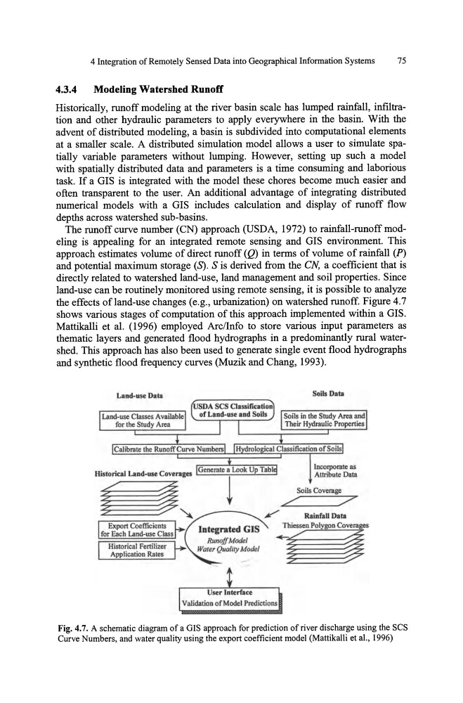
the effects ofland-use changes (e.g., urbanization) on watershed runoff. Figure 4.7
shows various stages of computation of this approach implemented within a GIS.
Mattikalli et al. (1996) employed Arc/Info to store various input parameters as
thematic layers and generated flood hydro graphs in a predominantly rural watershed. This approach has also been used to generate single event flood hydro graphs
and synthetic flood frequency curves (Muzik and Chang, 1993).
Land-use Data
Land-use Classes Available
for the Study Area
Export Coeffic ients
for Each Land-use Class
Historical Fertilizer
Application Rates
Soils Data
Soils in the Study Area and
Their Hydraulic Properties
Fig. 4.7. A schematic diagram of a GIS approach for prediction of river discharge using the SCS
Curve Numbers, and water quality using the export coefficient model (MattikaUi et a!., 1996)
75
4.3.4
Modeling Watershed Runoff
Historically, runoff modeling at the river basin scale has lumped rainfall, infiltration and other hydraulic parameters to apply everywhere in the basin. With the
advent of distributed modeling, a basin is subdivided into computational elements
at a smaller scale. A distributed simulation model allows a user to simulate spatially variable parameters without lumping. However, setting up such a model
with spatially distributed data and parameters is a time consuming and laborious
task. If a GIS is integrated with the model these chores become much easier and
often transparent to the user. An additional advantage of integrating distributed
numerical models with a GIS includes calculation and display of runoff flow
depths across watershed sub-basins.
The runoff curve number (CN) approach (USDA, 1972) to rainfall-runoff modeling is appealing for an integrated remote sensing and GIS environment. This
approach estimates volume of direct runoff (Q) in terms of volume of rainfall (P)
and potential maximum storage (S). S is derived from the eN, a coefficient that is
directly related to watershed land-use, land management and soil properties. Since
land-use can be routinely monitored using remote sensing, it is possible to analyze
the effects ofland-use changes (e.g., urbanization) on watershed runoff. Figure 4.7
shows various stages of computation of this approach implemented within a GIS.
Mattikalli et al. (1996) employed Arc/Info to store various input parameters as
thematic layers and generated flood hydro graphs in a predominantly rural watershed. This approach has also been used to generate single event flood hydro graphs
and synthetic flood frequency curves (Muzik and Chang, 1993).
Land-use Data
Land-use Classes Available
for the Study Area
Export Coeffic ients
for Each Land-use Class
Historical Fertilizer
Application Rates
Soils Data
Soils in the Study Area and
Their Hydraulic Properties
Fig. 4.7. A schematic diagram of a GIS approach for prediction of river discharge using the SCS
Curve Numbers, and water quality using the export coefficient model (MattikaUi et a!., 1996)