

3 Processing Remotely Sensed Data: Hardware and Software Considerations
51
important functions. The reader is encouraged to review textbooks on digital image processing and GIS to obtain specific information about the algorithms (Jahne,
1991; Lillesand and Kiefer, 1995; Jensen, 1996).
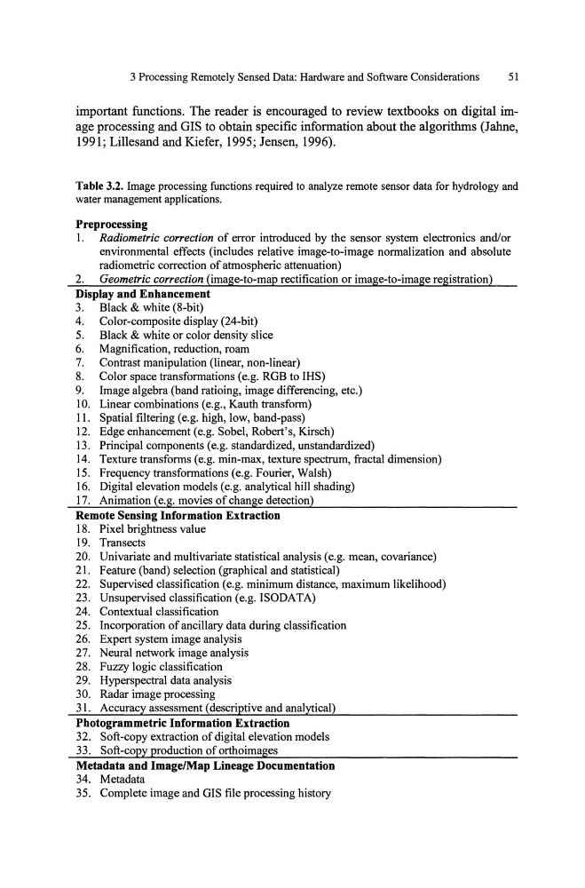
Table 3.2. Image processing functions required to analyze remote sensor data for hydrology and
water management applications.
Preprocessing
1. Radiometric correction of error introduced by the sensor system electronics and/or
environmental effects (includes relative image-to-image normalization and absolute
radiometric correction of atmospheric attenuation)
2. Geometric correction (image-to-map rectification or image-to-image registration)
Display and Enhancement
3. Black & white (S-bit)
4. Color-composite display (24-bit)
5. Black & white or color density slice
6. Magnification, reduction, roam
7. Contrast manipulation (linear, non-linear)
S. Color space transformations (e.g. RGB to IHS)
9. Image algebra (band ratioing, image differencing, etc.)
10. Linear combinations (e.g., Kauth transform)
II. Spatial filtering (e.g. high, low, band-pass)
12. Edge enhancement (e.g. Sobel, Robert's, Kirsch)
13. Principal components (e.g. standardized, unstandardized)
14. Texture transfonns (e.g. min-max, texture spectrum, fractal dimension)
15. Frequency transformations (e.g. Fourier, Walsh)
16. Digital elevation models (e.g. analytical hill shading)
17. Animation (e.g. movies of change detection)
Remote Sensing Information Extraction
IS. Pixel brightness value
19. Transects
20. Univariate and multivariate statistical analysis (e.g. mean, covariance)
21. Feature (band) selection (graphical and statistical)
22. Supervised classification (e.g. minimum distance, maximum likelihood)
23. Unsupervised classification (e.g. ISODATA)
24. Contextual classification
25. Incorporation of ancillary data during classification
26. Expert system image analysis
27. Neural network image analysis
2S. Fuzzy logic classification
29. Hyperspectral data analysis
30. Radar image processing
31. Accuracy assessment (descriptive and analytical)
Photogrammetric Information Extraction
32. Soft-copy extraction of digital elevation models
33. Soft-coPY production of orthoimages
Metadata and Image/Map Lineage Documentation
34. Metadata
35. Complete image and GIS file processing history
51
important functions. The reader is encouraged to review textbooks on digital image processing and GIS to obtain specific information about the algorithms (Jahne,
1991; Lillesand and Kiefer, 1995; Jensen, 1996).
Table 3.2. Image processing functions required to analyze remote sensor data for hydrology and
water management applications.
Preprocessing
1. Radiometric correction of error introduced by the sensor system electronics and/or
environmental effects (includes relative image-to-image normalization and absolute
radiometric correction of atmospheric attenuation)
2. Geometric correction (image-to-map rectification or image-to-image registration)
Display and Enhancement
3. Black & white (S-bit)
4. Color-composite display (24-bit)
5. Black & white or color density slice
6. Magnification, reduction, roam
7. Contrast manipulation (linear, non-linear)
S. Color space transformations (e.g. RGB to IHS)
9. Image algebra (band ratioing, image differencing, etc.)
10. Linear combinations (e.g., Kauth transform)
II. Spatial filtering (e.g. high, low, band-pass)
12. Edge enhancement (e.g. Sobel, Robert's, Kirsch)
13. Principal components (e.g. standardized, unstandardized)
14. Texture transfonns (e.g. min-max, texture spectrum, fractal dimension)
15. Frequency transformations (e.g. Fourier, Walsh)
16. Digital elevation models (e.g. analytical hill shading)
17. Animation (e.g. movies of change detection)
Remote Sensing Information Extraction
IS. Pixel brightness value
19. Transects
20. Univariate and multivariate statistical analysis (e.g. mean, covariance)
21. Feature (band) selection (graphical and statistical)
22. Supervised classification (e.g. minimum distance, maximum likelihood)
23. Unsupervised classification (e.g. ISODATA)
24. Contextual classification
25. Incorporation of ancillary data during classification
26. Expert system image analysis
27. Neural network image analysis
2S. Fuzzy logic classification
29. Hyperspectral data analysis
30. Radar image processing
31. Accuracy assessment (descriptive and analytical)
Photogrammetric Information Extraction
32. Soft-copy extraction of digital elevation models
33. Soft-coPY production of orthoimages
Metadata and Image/Map Lineage Documentation
34. Metadata
35. Complete image and GIS file processing history