

18 Computation of Hydrological Data
413
250
c::
0
200
!
r-~~ eaSUred I
O:;omputed I
'c, ~
.- .r::
a: c 150
... 0
Il.::!i
"'- ~ E
-
« E 100
~.r::
C
0
50
::!i
0
J1Irrt Ji' l WL
Jfl
M J J A SON 0 J F M A M J J A SON 0
1993
1994
~~r--------------•• ~~------------------------~.
Validation
Calibration
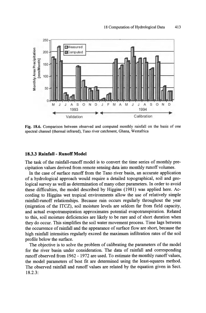
Fig. 18.6. Comparison between observed and computed monthly rainfall on the basis of one
spectral channel (thermal infrared), Tano river catchment, Ghana, Westafrica
18.3.3 Rainfall - Runoff Model
The task of the rainfall-runoff model is to convert the time series of monthly precipitation values derived from remote sensing data into monthly runoff volumes.
In the case of surface runoff from the Tano river basin, an accurate application
of a hydrological approach would require a detailed topographical, soil and geological survey as well as determination of many other parameters. In order to avoid
these difficulties, the model described by Higgins (1981) was applied here. According to Higgins wet tropical environments allow the use of relatively simple
rainfall-runoff relationships. Because rain occurs regularly throughout the year
(migration of the ITCZ) , soil moisture levels are seldom far from field capacity,
and actual evapotranspiration approximates potential evapotranspiration. Related
to this, soil moisture deficiencies are likely to be rare and of short duration when
they do occur. This simplifies the soil water movement process. Time lags between
the occurrence of rainfall and the appearance of surface flow are short, because the
high rainfall intensities regularly exceed the maximum infiltration rates of the soil
profile below the surface.
The objective is to solve the problem of calibrating the parameters of the model
for the river basin under consideration. The data of rainfall and corresponding
runoff observed from 1962 - 1972 are used. To estimate the monthly runoff values,
the model parameters of best fit are determined using the least-squares method.
The observed rainfall and runoff values are related by the equation given in Sect.
18.2.3:
413
250
c::
0
200
!
r-~~ eaSUred I
O:;omputed I
'c, ~
.- .r::
a: c 150
... 0
Il.::!i
"'- ~ E
-
« E 100
~.r::
C
0
50
::!i
0
J1Irrt Ji' l WL
Jfl
M J J A SON 0 J F M A M J J A SON 0
1993
1994
~~r--------------•• ~~------------------------~.
Validation
Calibration
Fig. 18.6. Comparison between observed and computed monthly rainfall on the basis of one
spectral channel (thermal infrared), Tano river catchment, Ghana, Westafrica
18.3.3 Rainfall - Runoff Model
The task of the rainfall-runoff model is to convert the time series of monthly precipitation values derived from remote sensing data into monthly runoff volumes.
In the case of surface runoff from the Tano river basin, an accurate application
of a hydrological approach would require a detailed topographical, soil and geological survey as well as determination of many other parameters. In order to avoid
these difficulties, the model described by Higgins (1981) was applied here. According to Higgins wet tropical environments allow the use of relatively simple
rainfall-runoff relationships. Because rain occurs regularly throughout the year
(migration of the ITCZ) , soil moisture levels are seldom far from field capacity,
and actual evapotranspiration approximates potential evapotranspiration. Related
to this, soil moisture deficiencies are likely to be rare and of short duration when
they do occur. This simplifies the soil water movement process. Time lags between
the occurrence of rainfall and the appearance of surface flow are short, because the
high rainfall intensities regularly exceed the maximum infiltration rates of the soil
profile below the surface.
The objective is to solve the problem of calibrating the parameters of the model
for the river basin under consideration. The data of rainfall and corresponding
runoff observed from 1962 - 1972 are used. To estimate the monthly runoff values,
the model parameters of best fit are determined using the least-squares method.
The observed rainfall and runoff values are related by the equation given in Sect.
18.2.3: