

16 Flood Forecasting and Control
Gert A. Schultz
Ruhr University Bochum, 44790 Bochum, Germany
16.1 Introduction
The International Decade for Natural Disaster Reduction (IDNDR) considers
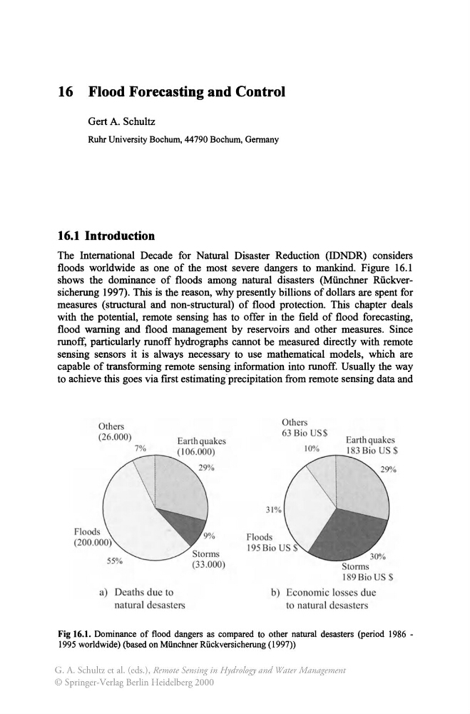
floods worldwide as one of the most severe dangers to mankind. Figure 16.1
shows the dominance of floods among natural disasters (Miinchner Riickversicherung 1997). This is the reason, why presently billions of dollars are spent for
measures (structural and non-structural) of flood protection. This chapter deals
with the potential, remote sensing has to offer in the field of flood forecasting,
flood warning and flood management by reservoirs and other measures. Since
runoff, particularly runoff hydrographs cannot be measured directly with remote
sensing sensors it is always necessary to use mathematical models, which are
capable of transforming remote sensing information into runoff. Usually the way
to achieve this goes via first estimating· precipitation from remote sensing data and
Others
(26.000)
7%
a) Death due to
natural desasters
Others
63 Bio US
Earth quakes
10%
1 83 Bio U $
--.,--..31%
b) conomic losses due
to natura I desasters
Fig 16.1. Dominance of flood dangers as compared to other natural desasters (period 1986 -
1995 worldwide) (based on Miinchner Riickversicherung (1997»
G. A. Schultz et al. (eds.), Remote Sensing in Hydrology and Water Management
© Springer-Verlag Berlin Heidelberg 2000
Gert A. Schultz
Ruhr University Bochum, 44790 Bochum, Germany
16.1 Introduction
The International Decade for Natural Disaster Reduction (IDNDR) considers
floods worldwide as one of the most severe dangers to mankind. Figure 16.1
shows the dominance of floods among natural disasters (Miinchner Riickversicherung 1997). This is the reason, why presently billions of dollars are spent for
measures (structural and non-structural) of flood protection. This chapter deals
with the potential, remote sensing has to offer in the field of flood forecasting,
flood warning and flood management by reservoirs and other measures. Since
runoff, particularly runoff hydrographs cannot be measured directly with remote
sensing sensors it is always necessary to use mathematical models, which are
capable of transforming remote sensing information into runoff. Usually the way
to achieve this goes via first estimating· precipitation from remote sensing data and
Others
(26.000)
7%
a) Death due to
natural desasters
Others
63 Bio US
Earth quakes
10%
1 83 Bio U $
--.,--..31%
b) conomic losses due
to natura I desasters
Fig 16.1. Dominance of flood dangers as compared to other natural desasters (period 1986 -
1995 worldwide) (based on Miinchner Riickversicherung (1997»
G. A. Schultz et al. (eds.), Remote Sensing in Hydrology and Water Management
© Springer-Verlag Berlin Heidelberg 2000