

1)
3)
15 Introduction to and General Aspects of Water Management
339
2)
-
o
,
Legend
~Gneiss plateau (1,2)
1 DI!i:s.ecled hills
Highly dissected
hillS
3 Sedimentary share
& sandstone area,
with alluvial flOOd
prain and swamps
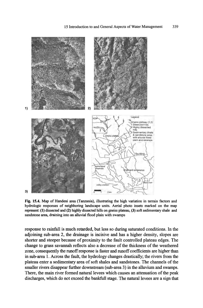
Fig. 15.4. Map of Handeni area (Tanzania), illustrating the high variation in terrain factors and
hydrologic responses of neighboring landscape units. Aerial photo insets marked on the map
represent: (1) dissected and (2) highly dissected hills on gneiss plateau, (3) soft sedimentary shale and
sandstone area, draining into an alluvial flood plain with swamps
response to rainfall is much retarded, but less so during saturated conditions. In the
adjoining sub-area 2, the drainage is incisive and has a higher density, slopes are
shorter and steeper because of proximity to the fault controlled plateau edges. The
change to grass savannah reflects also a decrease of the thickness of the weathered
zone, consequently the runoff response is faster and runoff coefficients are higher than
in sub-area 1. Across the fault, the hydrology changes drastically; the rivers from the
plateau enter a sedimentary area of soft shales and sandstones. The channels of the
smaller rivers disappear further downstream (sub-area 3) in the alluvium and swamps.
There, the main river formed natural levees which causes an attenuation of the peak
discharges, which do not exceed the bankfull stage. The natural levees are a sign that
3)
15 Introduction to and General Aspects of Water Management
339
2)
-
o
,
Legend
~Gneiss plateau (1,2)
1 DI!i:s.ecled hills
Highly dissected
hillS
3 Sedimentary share
& sandstone area,
with alluvial flOOd
prain and swamps
Fig. 15.4. Map of Handeni area (Tanzania), illustrating the high variation in terrain factors and
hydrologic responses of neighboring landscape units. Aerial photo insets marked on the map
represent: (1) dissected and (2) highly dissected hills on gneiss plateau, (3) soft sedimentary shale and
sandstone area, draining into an alluvial flood plain with swamps
response to rainfall is much retarded, but less so during saturated conditions. In the
adjoining sub-area 2, the drainage is incisive and has a higher density, slopes are
shorter and steeper because of proximity to the fault controlled plateau edges. The
change to grass savannah reflects also a decrease of the thickness of the weathered
zone, consequently the runoff response is faster and runoff coefficients are higher than
in sub-area 1. Across the fault, the hydrology changes drastically; the rivers from the
plateau enter a sedimentary area of soft shales and sandstones. The channels of the
smaller rivers disappear further downstream (sub-area 3) in the alluvium and swamps.
There, the main river formed natural levees which causes an attenuation of the peak
discharges, which do not exceed the bankfull stage. The natural levees are a sign that