

14 Groundwater
319
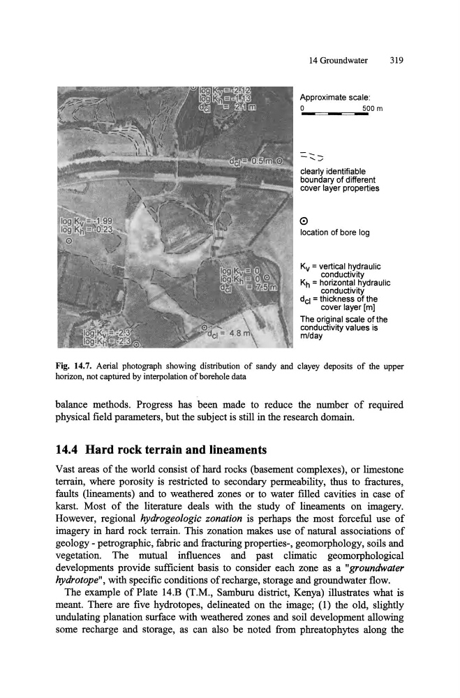
Approximate scale:
o
500 m
clearly identifiable
boundary of different
cover layer properties
o
location of bore log
Kv = vertical hydraulic
conductivity
Kh = horizontal hydraulic
conductivity
dcl = thickness of the
cover layer [m]
The original scale of the
conductivity values is
m/day
Fig. 14.7. Aerial photograph showing distribution of sandy and clayey deposits of the upper
horizon, not captUred by interpolation of borehole data
balance methods. Progress has been made to reduce the number of required
physical field parameters, but the subject is still in the research domain.
14.4 Hard rock terrain and lineaments
Vast areas of the world consist of hard rocks (basement complexes), or limestone
terrain, where porosity is restricted to secondary permeability, thus to fractures,
faults (lineaments) and to weathered zones or to water filled cavities in case of
karst. Most of the literature deals with the study of lineaments on imagery.
However, regional hydrogeologic zonation is perhaps the most forceful use of
imagery in hard rock terrain. This zonation makes use of natural associations of
geology - petrographic, fabric and fracturing properties-, geomorphology, soils and
vegetation. The mutual influences and past climatic geomorphological
developments provide sufficient basis to consider each zone as a "groundwater
hydrotope", with specific conditions of recharge, storage and groundwater flow.
The example of Plate 14.B (T.M., Samburu district, Kenya) illustrates what is
meant. There are five hydrotopes, delineated on the image; (l) the old, slightly
undulating planation surface with weathered zones and soil development allowing
some recharge and storage, as can also be noted from phreatophytes along the
319
Approximate scale:
o
500 m
clearly identifiable
boundary of different
cover layer properties
o
location of bore log
Kv = vertical hydraulic
conductivity
Kh = horizontal hydraulic
conductivity
dcl = thickness of the
cover layer [m]
The original scale of the
conductivity values is
m/day
Fig. 14.7. Aerial photograph showing distribution of sandy and clayey deposits of the upper
horizon, not captUred by interpolation of borehole data
balance methods. Progress has been made to reduce the number of required
physical field parameters, but the subject is still in the research domain.
14.4 Hard rock terrain and lineaments
Vast areas of the world consist of hard rocks (basement complexes), or limestone
terrain, where porosity is restricted to secondary permeability, thus to fractures,
faults (lineaments) and to weathered zones or to water filled cavities in case of
karst. Most of the literature deals with the study of lineaments on imagery.
However, regional hydrogeologic zonation is perhaps the most forceful use of
imagery in hard rock terrain. This zonation makes use of natural associations of
geology - petrographic, fabric and fracturing properties-, geomorphology, soils and
vegetation. The mutual influences and past climatic geomorphological
developments provide sufficient basis to consider each zone as a "groundwater
hydrotope", with specific conditions of recharge, storage and groundwater flow.
The example of Plate 14.B (T.M., Samburu district, Kenya) illustrates what is
meant. There are five hydrotopes, delineated on the image; (l) the old, slightly
undulating planation surface with weathered zones and soil development allowing
some recharge and storage, as can also be noted from phreatophytes along the