

14 Groundwater
315
Other elements of terrain segmentation for recharge using imagery are the
mapping of river beds with transmission losses.
The Colour Plate 14.A (north Iran) shows ephemeral river beds. The snowmelt
runoff and seasonal rainfall runoff, during the period March to June, from the hills
is the most important source of recharge of the aquifer formed by the alluvial fan
deposits (fanglomerates). It is apparent from the image that most rivers do not
reach the central drainage line, because the runoff infiltrates fully. The rapid
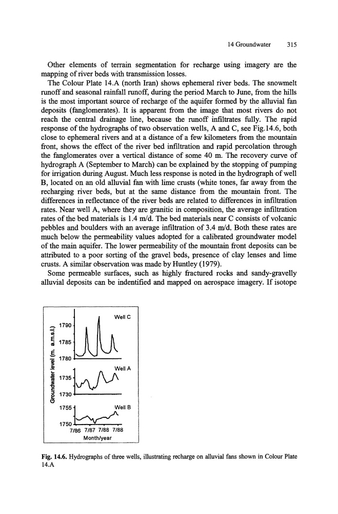
response of the hydro graphs of two observation wells, A and C, see Fig.14.6, both
close to ephemeral rivers and at a distance of a few kilometers from the mountain
front, shows the effect of the river bed infiltration and rapid percolation through
the fanglomerates over a vertical distance of some 40 m. The recovery curve of
hydrograph A (September to March) can be explained by the stopping of pumping
for irrigation during August. Much less response is noted in the hydro graph of well
B, located on an old alluvial fan with lime crusts (white tones, far away from the
recharging river beds, but at the same distance from the mountain front. The
differences in reflectance of the river beds are related to differences in infiltration
rates. Near well A, where they are granitic in composition, the average infiltration
rates of the bed materials is 1.4 mid. The bed materials near C consists of volcanic
pebbles and boulders with an average infiltration of 3.4 mid. Both these rates are
much below the permeability values adopted for a calibrated groundwater model
of the main aquifer. The lower permeability of the mountain front deposits can be
attributed to a poor sorting of the gravel beds, presence of clay lenses and lime
crusts. A similar observation was made by Huntley (1979).
Some permeable surfaces, such as highly fractured rocks and sandy-gravelly
alluvial deposits can be indentified and mapped on aerospace imagery. If isotope
:; 1790 ili
ell
C
5 1785
E
i 1780 ~--'---R 1735j _ f\ ;'"
I v'V ~
S 1730
1755]~eIlB
1 7 5 0 .
.
7/86 7/87 7/88 7/88
Monthlyear
Fig. 14.6. Hydrographs of three wells, illustrating recharge on alluvial fans shown in Colour Plate
14.A
315
Other elements of terrain segmentation for recharge using imagery are the
mapping of river beds with transmission losses.
The Colour Plate 14.A (north Iran) shows ephemeral river beds. The snowmelt
runoff and seasonal rainfall runoff, during the period March to June, from the hills
is the most important source of recharge of the aquifer formed by the alluvial fan
deposits (fanglomerates). It is apparent from the image that most rivers do not
reach the central drainage line, because the runoff infiltrates fully. The rapid
response of the hydro graphs of two observation wells, A and C, see Fig.14.6, both
close to ephemeral rivers and at a distance of a few kilometers from the mountain
front, shows the effect of the river bed infiltration and rapid percolation through
the fanglomerates over a vertical distance of some 40 m. The recovery curve of
hydrograph A (September to March) can be explained by the stopping of pumping
for irrigation during August. Much less response is noted in the hydro graph of well
B, located on an old alluvial fan with lime crusts (white tones, far away from the
recharging river beds, but at the same distance from the mountain front. The
differences in reflectance of the river beds are related to differences in infiltration
rates. Near well A, where they are granitic in composition, the average infiltration
rates of the bed materials is 1.4 mid. The bed materials near C consists of volcanic
pebbles and boulders with an average infiltration of 3.4 mid. Both these rates are
much below the permeability values adopted for a calibrated groundwater model
of the main aquifer. The lower permeability of the mountain front deposits can be
attributed to a poor sorting of the gravel beds, presence of clay lenses and lime
crusts. A similar observation was made by Huntley (1979).
Some permeable surfaces, such as highly fractured rocks and sandy-gravelly
alluvial deposits can be indentified and mapped on aerospace imagery. If isotope
:; 1790 ili
ell
C
5 1785
E
i 1780 ~--'---R 1735j _ f\ ;'"
I v'V ~
S 1730
1755]~eIlB
1 7 5 0 .
.
7/86 7/87 7/88 7/88
Monthlyear
Fig. 14.6. Hydrographs of three wells, illustrating recharge on alluvial fans shown in Colour Plate
14.A