

282
J.C. Ritchie
development of rills on the landscape. These studies are leading to a better understanding of the mechanism of soil particle detachment and movement.
The same laser techniques have been used with an airborne laser altimeter (Ritchie
1996) to study soil erosional features of the landscape. Landscape features related to
soil erosion such as topography, stream channels, gullies, and canopy cover can be
measured. The airborne laser measurements provide quick and accurate data on the
morphology and roughness of the landscape surface (Ritchie and Jackson 1989).
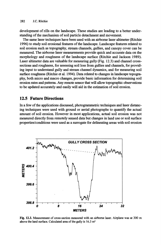
Laser altimeter data are valuable for measuring gully (Fig. 12.3) and channel crosssections and roughness, for assessing soil loss from gullies and channels, for providing input to understand gully and stream channel dynamics, and for measuring soil
surface roughness (Ritchie et al. 1994). Data related to changes in landscape topography, both micro and macro changes, provide basic information for determining soil
erosion rates and patterns. Any remote sensor that will allow topographic observations
to be updated accurately and easily will aid in the estimation of soil erosion.
12.5 Future Directions
In a few of the applications discussed, photogrammetric techniques and laser distancing techniques were used with ground or aerial photographs to quantify the actual
amount of soil erosion. However in most applications, actual soil erosion was not
measured directly from remotely sensed data but changes in land use or soil surface
properties/conditions were used as a surrogate for delineating areas with soil erosion
401.2
~ 400.4
~
~
399.6
o
8
GULL Y CROSS SECTION
16
METERS
24
32
Fig. 12.3. Measurement of cross-section measured with an airborne laser. Airplane was at 300 m
above the land surface. Calculated area of the gully is 16.3 m 2
J.C. Ritchie
development of rills on the landscape. These studies are leading to a better understanding of the mechanism of soil particle detachment and movement.
The same laser techniques have been used with an airborne laser altimeter (Ritchie
1996) to study soil erosional features of the landscape. Landscape features related to
soil erosion such as topography, stream channels, gullies, and canopy cover can be
measured. The airborne laser measurements provide quick and accurate data on the
morphology and roughness of the landscape surface (Ritchie and Jackson 1989).
Laser altimeter data are valuable for measuring gully (Fig. 12.3) and channel crosssections and roughness, for assessing soil loss from gullies and channels, for providing input to understand gully and stream channel dynamics, and for measuring soil
surface roughness (Ritchie et al. 1994). Data related to changes in landscape topography, both micro and macro changes, provide basic information for determining soil
erosion rates and patterns. Any remote sensor that will allow topographic observations
to be updated accurately and easily will aid in the estimation of soil erosion.
12.5 Future Directions
In a few of the applications discussed, photogrammetric techniques and laser distancing techniques were used with ground or aerial photographs to quantify the actual
amount of soil erosion. However in most applications, actual soil erosion was not
measured directly from remotely sensed data but changes in land use or soil surface
properties/conditions were used as a surrogate for delineating areas with soil erosion
401.2
~ 400.4
~
~
399.6
o
8
GULL Y CROSS SECTION
16
METERS
24
32
Fig. 12.3. Measurement of cross-section measured with an airborne laser. Airplane was at 300 m
above the land surface. Calculated area of the gully is 16.3 m 2