

11 Snow and Ice
255
India Runoff Forecasts. Some good examples of operational application of snow
extent data are found in India. Initially Ramamoorthi (1983; 1987) started to use
NOAA-A VHRR data in a simple regression approach for empirical forecasts of
seasonal snowmelt runoff in the Sutlej River Basin (43,230 km 2 ) and the forecasts
were extended to other basins. Ramamoorthi (1987) also decided to use satellite data
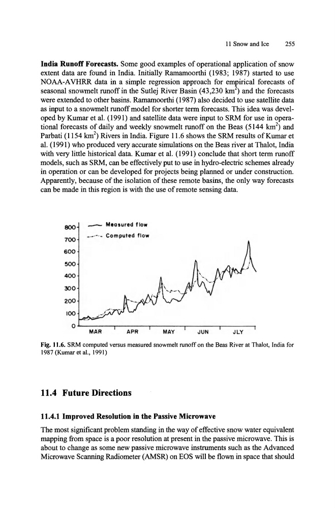
as input to a snowmelt runoff model for shorter term forecasts. This idea was developed by Kumar et al. (1991) and satellite data were input to SRM for use in operational forecasts of daily and weekly snowmelt runoff on the Beas (5144 km 2 ) and
Parbati (1154 km 2 ) Rivers in India. Figure 11.6 shows the SRM results of Kumar et
al. (1991) who produced very accurate simulations on the Beas river at Thalot, India
with very little historical data. Kumar et al. (1991) conclude that short term runoff
models, such as SRM, can be effectively put to use in hydro-electric schemes already
in operation or can be developed for projects being planned or under construction.
Apparently, because of the isolation of these remote basins, the only way forecasts
can be made in this region is with the use of remote sensing data.
800
700
600
500
400
300
200
100
_
Measured flow
_._.-. _ Computed flow
OL-------.--------.-------,-------.,------.
MAR
APR
MAY
JUN
JLY
Fig. 11.6. SRM computed versus measured snowmelt runoff on the Beas River at Thalot, India for
1987 (Kumar et aI., 1991)
11.4 Future Directions
11.4.1 Improved Resolution in the Passive Microwave
The most significant problem standing in the way of effective snow water equivalent
mapping from space is a poor resolution at present in the passive microwave. This is
about to change as some new passive microwave instruments such as the Advanced
Microwave Scanning Radiometer (AMSR) on EOS will be flown in space that should
255
India Runoff Forecasts. Some good examples of operational application of snow
extent data are found in India. Initially Ramamoorthi (1983; 1987) started to use
NOAA-A VHRR data in a simple regression approach for empirical forecasts of
seasonal snowmelt runoff in the Sutlej River Basin (43,230 km 2 ) and the forecasts
were extended to other basins. Ramamoorthi (1987) also decided to use satellite data
as input to a snowmelt runoff model for shorter term forecasts. This idea was developed by Kumar et al. (1991) and satellite data were input to SRM for use in operational forecasts of daily and weekly snowmelt runoff on the Beas (5144 km 2 ) and
Parbati (1154 km 2 ) Rivers in India. Figure 11.6 shows the SRM results of Kumar et
al. (1991) who produced very accurate simulations on the Beas river at Thalot, India
with very little historical data. Kumar et al. (1991) conclude that short term runoff
models, such as SRM, can be effectively put to use in hydro-electric schemes already
in operation or can be developed for projects being planned or under construction.
Apparently, because of the isolation of these remote basins, the only way forecasts
can be made in this region is with the use of remote sensing data.
800
700
600
500
400
300
200
100
_
Measured flow
_._.-. _ Computed flow
OL-------.--------.-------,-------.,------.
MAR
APR
MAY
JUN
JLY
Fig. 11.6. SRM computed versus measured snowmelt runoff on the Beas River at Thalot, India for
1987 (Kumar et aI., 1991)
11.4 Future Directions
11.4.1 Improved Resolution in the Passive Microwave
The most significant problem standing in the way of effective snow water equivalent
mapping from space is a poor resolution at present in the passive microwave. This is
about to change as some new passive microwave instruments such as the Advanced
Microwave Scanning Radiometer (AMSR) on EOS will be flown in space that should