

10 Remote Sensing of Surface Water
229
function. The response function was derived from calibration of estimated and
recorded runoff. A similar model using Meteosat data was developed by Papadakis
(see Chap. 18). Development of this concept has led to extremely advanced distributed hydrological models such as the NOAA Nile forecasting system, which estimates
inflows to Lake Nasser based on satellite estimates of pre~ipitation over Ethiopia
(Barrett, 1993). In this model, METEOSAT data are used to estimate precipitation
because of the almost total lack of recorded precipitation data in the source area of
the Blue Nile. The precipitation data are input to a distributed (11,000 grid squares
at 30 km 2 each) rainfall-runoff model consisting of a vertical water balance, a hillslope routing component and a channel routing component. Another model estimating
flows of the Blue Nile with the aid of remote sensing data is described in Chap. 18.
Other hydrological models use remotely sensed data for land cover classifications
and vegetation activity indices. The SLURP semi-distributed model (Kite, 1995)
divides a basin into hydrological sub-basins and into land classes using either NOAA
A VHRR or Landsat data depending on the size of the basin. The model then carries
out a vertical water balance for each land cover area within each sub-basin and
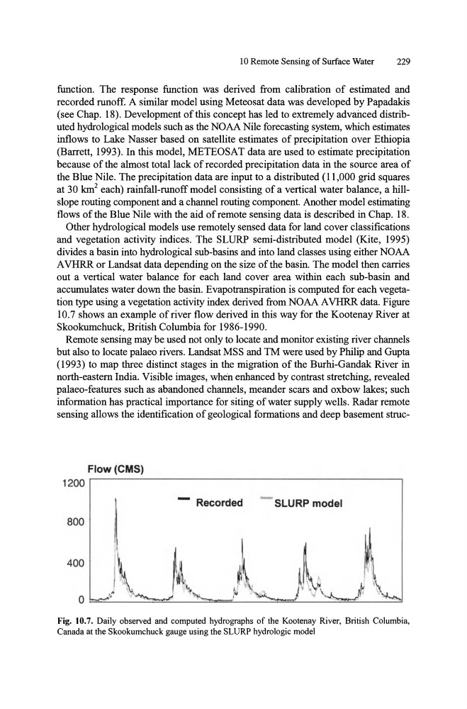
accumulates water down the basin. Evapotranspiration is computed for each vegetation type using a vegetation activity index derived from NOAA A VHRR data. Figure
10.7 shows an example of river flow derived in this way for the Kootenay River at
Skookumchuck, British Columbia for 1986-1990.
Remote sensing may be used not only to locate and monitor existing river channels
but also to locate palaeo rivers. Landsat MSS and TM were used by Philip and Gupta
(1993) to map three distinct stages in the migration of the Burhi-Gandak River in
north-eastern India. Visible images, when enhanced by contrast stretching, revealed
palaeo-features such as abandoned channels, meander scars and oxbow lakes; such
information has practical importance for siting of water supply wells. Radar remote
sensing allows the identification of geological formations and deep basement strucFlow (CMS)
1200
-
Recorded
- SLURP model
800
Fig. 10.7. Daily observed and computed hydrographs of the Kootenay River, British Columbia,
Canada at the Skookumchuck gauge using the SLURP hydrologic model
229
function. The response function was derived from calibration of estimated and
recorded runoff. A similar model using Meteosat data was developed by Papadakis
(see Chap. 18). Development of this concept has led to extremely advanced distributed hydrological models such as the NOAA Nile forecasting system, which estimates
inflows to Lake Nasser based on satellite estimates of pre~ipitation over Ethiopia
(Barrett, 1993). In this model, METEOSAT data are used to estimate precipitation
because of the almost total lack of recorded precipitation data in the source area of
the Blue Nile. The precipitation data are input to a distributed (11,000 grid squares
at 30 km 2 each) rainfall-runoff model consisting of a vertical water balance, a hillslope routing component and a channel routing component. Another model estimating
flows of the Blue Nile with the aid of remote sensing data is described in Chap. 18.
Other hydrological models use remotely sensed data for land cover classifications
and vegetation activity indices. The SLURP semi-distributed model (Kite, 1995)
divides a basin into hydrological sub-basins and into land classes using either NOAA
A VHRR or Landsat data depending on the size of the basin. The model then carries
out a vertical water balance for each land cover area within each sub-basin and
accumulates water down the basin. Evapotranspiration is computed for each vegetation type using a vegetation activity index derived from NOAA A VHRR data. Figure
10.7 shows an example of river flow derived in this way for the Kootenay River at
Skookumchuck, British Columbia for 1986-1990.
Remote sensing may be used not only to locate and monitor existing river channels
but also to locate palaeo rivers. Landsat MSS and TM were used by Philip and Gupta
(1993) to map three distinct stages in the migration of the Burhi-Gandak River in
north-eastern India. Visible images, when enhanced by contrast stretching, revealed
palaeo-features such as abandoned channels, meander scars and oxbow lakes; such
information has practical importance for siting of water supply wells. Radar remote
sensing allows the identification of geological formations and deep basement strucFlow (CMS)
1200
-
Recorded
- SLURP model
800
Fig. 10.7. Daily observed and computed hydrographs of the Kootenay River, British Columbia,
Canada at the Skookumchuck gauge using the SLURP hydrologic model