

10 Remote Sensing of Surface Water
225
pheric corrections, geoid undulation, temporal variation and spacecraft location
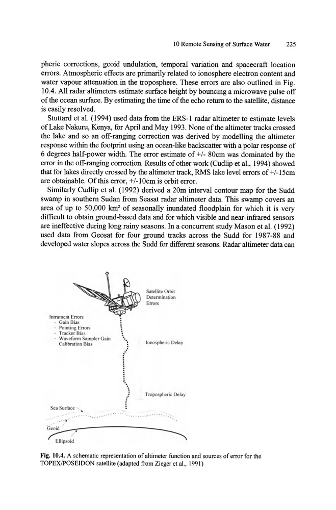
errors. Atmospheric effects are primarily related to ionosphere electron content and
water vapour attenuation in the troposphere. These errors are also outlined in Fig.
lOA. All radar altimeters estimate surface height by bouncing a microwave pulse off
of the ocean surface. By estimating the time of the echo return to the satellite, distance
is easily resolved.
Stuttard et aI. (1994) used data from the ERS-l radar altimeter to estimate levels
of Lake Nakuru, Kenya, for April and May 1993. None of the altimeter tracks crossed
the lake and so an off-ranging correction was derived by modelling the altimeter
response within the footprint using an ocean-like backscatter with a polar response of
6 degrees half-power width. The error estimate of +/- 80cm was dominated by the
error in the off-ranging correction. Results of other work (Cudlip et aI., 1994) showed
that for lakes directly crossed by the altimeter track, RMS lake level errors of +/-15cm
are obtainable. Of this error, +/-1 Ocm is orbit error.
Similarly Cudlip et aI. (1992) derived a 20m interval contour map for the Sudd
swamp in southern Sudan from Seasat radar altimeter data. This swamp covers an
area of up to 50,000 km 2 of seasonally inundated floodplain for which it is very
difficult to obtain ground-based data and for which visible and near-infrared sensors
are ineffective during long rainy seasons. In a concurrent study Mason et aI. (1992)
used data from Geosat for four ground tracks across the Sudd for 1987-88 and
developed water slopes across the Sudd for different seasons. Radar altimeter data can
Inrrumem Error.;
• Gain Bias
.. Point ing Errors
• Tracker Bias
• Wa veronn Samplcr Gain
Cali bralion Bias
Sca urface " •
.. ' - . ~ '
Geoid
lIipsoid
aleilile Orbil
Delenninalion
Error.;
I Ionospheric Delay
Tropospheric Delay
Fig. 10.4. A schematic representation of altimeter function and sources of error for the
TOPEX/POSEIDON satellite (adapted from Zieger et aI., 1991)
225
pheric corrections, geoid undulation, temporal variation and spacecraft location
errors. Atmospheric effects are primarily related to ionosphere electron content and
water vapour attenuation in the troposphere. These errors are also outlined in Fig.
lOA. All radar altimeters estimate surface height by bouncing a microwave pulse off
of the ocean surface. By estimating the time of the echo return to the satellite, distance
is easily resolved.
Stuttard et aI. (1994) used data from the ERS-l radar altimeter to estimate levels
of Lake Nakuru, Kenya, for April and May 1993. None of the altimeter tracks crossed
the lake and so an off-ranging correction was derived by modelling the altimeter
response within the footprint using an ocean-like backscatter with a polar response of
6 degrees half-power width. The error estimate of +/- 80cm was dominated by the
error in the off-ranging correction. Results of other work (Cudlip et aI., 1994) showed
that for lakes directly crossed by the altimeter track, RMS lake level errors of +/-15cm
are obtainable. Of this error, +/-1 Ocm is orbit error.
Similarly Cudlip et aI. (1992) derived a 20m interval contour map for the Sudd
swamp in southern Sudan from Seasat radar altimeter data. This swamp covers an
area of up to 50,000 km 2 of seasonally inundated floodplain for which it is very
difficult to obtain ground-based data and for which visible and near-infrared sensors
are ineffective during long rainy seasons. In a concurrent study Mason et aI. (1992)
used data from Geosat for four ground tracks across the Sudd for 1987-88 and
developed water slopes across the Sudd for different seasons. Radar altimeter data can
Inrrumem Error.;
• Gain Bias
.. Point ing Errors
• Tracker Bias
• Wa veronn Samplcr Gain
Cali bralion Bias
Sca urface " •
.. ' - . ~ '
Geoid
lIipsoid
aleilile Orbil
Delenninalion
Error.;
I Ionospheric Delay
Tropospheric Delay
Fig. 10.4. A schematic representation of altimeter function and sources of error for the
TOPEX/POSEIDON satellite (adapted from Zieger et aI., 1991)