

164
M. Menenti
vations were used to obtain radiative forcing (solar radiation, albedo; ISCCP see
Table 8.1), canopy resistance as a function of Photosyntetically Active Radiation
(PAR; ISCCP see Table 8.1), air temperature and vapour pressure (TOVS; see
Table 8.1) and fractional vegetation cover (A VHRR).
Water balance - air. The water balance of an atmospheric column reads:
bV +divq =E-P
/it
v
(8.6)
where ov is change in atmospheric water vapour and div qv is horizontal divergence of vertically integrated vapour flux. Starr and Peixoto (1958) and Peixoto
(1970) used this principle to study divergence of water vapour with world-wide
atmospheric soundings. Oki et al. (1995) used vertical profiles of water vapour
density produced with the 4DDA system of the European Centre for Medium
range Weather Forecasts (ECMWF). These data, especially in tropical regions,
depend heavily on the use of satellite sounders. Moreover the same approach can
in principle be applied with the observations provided by satellite sounders only,
although accuracy, vertical and horizontal resolutions might not be adequate. The
same conceptual approach has been applied by Eichinger et al. (1991) using a Raman lidar to scan repeatedly a relatively small air mass close to the land surface to
determine the vapour budget and evaporation.
The challenge to all remote-sensing methods to estimate land evaporation is how
to determine model variables not directly related to feasible observations. The
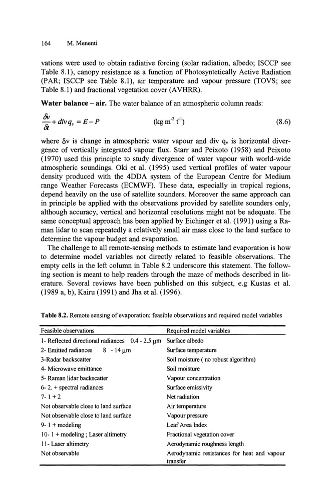
empty cells in the left column in Table 8.2 underscore this statement. The following section is meant to help readers through the maze of methods described in literature. Several reviews have been published on this subject, e.g Kustas et al.
(1989 a, b), Kairu (1991) and Jha et al. (1996).
Table 8.2. Remote sensing of evaporation: feasible observations and required model variables
Feasible observations
Required model variables
1- Reflected directional radiances 0.4 - 2.5 11m Surface albedo
2- Emitted radiances
8 - 14 11m
Surface temperature
3-Radar backscatter
Soil moisture ( no robust algorithm)
4- Microwave emittance
5- Raman lidar backscatter
6- 2. + spectral radiances
7- I + 2
Not observable close to land surface
Not observable close to land surface
9- I + modeling
10- I + modeling; Laser altimetry
11- Laser al timetry
Not observable
Soil moisture
Vapour concentration
Surface emissivity
Net radiation
Air temperature
Vapour pressure
Leaf Area Index
Fractional vegetation cover
Aerodynamic roughness length
Aerodynamic resistances for heat and vapour
transfer
M. Menenti
vations were used to obtain radiative forcing (solar radiation, albedo; ISCCP see
Table 8.1), canopy resistance as a function of Photosyntetically Active Radiation
(PAR; ISCCP see Table 8.1), air temperature and vapour pressure (TOVS; see
Table 8.1) and fractional vegetation cover (A VHRR).
Water balance - air. The water balance of an atmospheric column reads:
bV +divq =E-P
/it
v
(8.6)
where ov is change in atmospheric water vapour and div qv is horizontal divergence of vertically integrated vapour flux. Starr and Peixoto (1958) and Peixoto
(1970) used this principle to study divergence of water vapour with world-wide
atmospheric soundings. Oki et al. (1995) used vertical profiles of water vapour
density produced with the 4DDA system of the European Centre for Medium
range Weather Forecasts (ECMWF). These data, especially in tropical regions,
depend heavily on the use of satellite sounders. Moreover the same approach can
in principle be applied with the observations provided by satellite sounders only,
although accuracy, vertical and horizontal resolutions might not be adequate. The
same conceptual approach has been applied by Eichinger et al. (1991) using a Raman lidar to scan repeatedly a relatively small air mass close to the land surface to
determine the vapour budget and evaporation.
The challenge to all remote-sensing methods to estimate land evaporation is how
to determine model variables not directly related to feasible observations. The
empty cells in the left column in Table 8.2 underscore this statement. The following section is meant to help readers through the maze of methods described in literature. Several reviews have been published on this subject, e.g Kustas et al.
(1989 a, b), Kairu (1991) and Jha et al. (1996).
Table 8.2. Remote sensing of evaporation: feasible observations and required model variables
Feasible observations
Required model variables
1- Reflected directional radiances 0.4 - 2.5 11m Surface albedo
2- Emitted radiances
8 - 14 11m
Surface temperature
3-Radar backscatter
Soil moisture ( no robust algorithm)
4- Microwave emittance
5- Raman lidar backscatter
6- 2. + spectral radiances
7- I + 2
Not observable close to land surface
Not observable close to land surface
9- I + modeling
10- I + modeling; Laser altimetry
11- Laser al timetry
Not observable
Soil moisture
Vapour concentration
Surface emissivity
Net radiation
Air temperature
Vapour pressure
Leaf Area Index
Fractional vegetation cover
Aerodynamic roughness length
Aerodynamic resistances for heat and vapour
transfer