

152
B.G.H. Gorte
LandImage
use map
1985
Local prior classification
1985
LandImage
C>
0
1996
Local prior
use map iii
0
1996
3
classification
0
I 1
li
Multi~ ~
ChangePrelim.
temporal -
;:. ,- classes
change
Image
~ ~
train. set Selection map
.. CD
- =
gg
Multitemporal
class.ication
Colour Plate 70
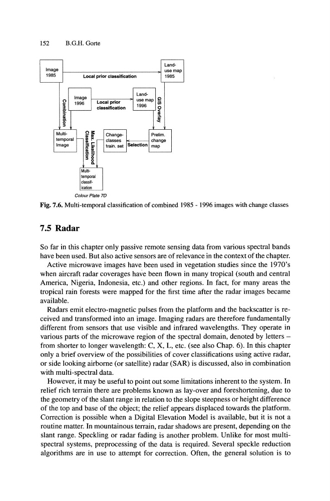
Fig. 7.6. Multi-temporal classification of combined 1985 - 1996 images with change classes
7.5 Radar
So far in this chapter only passive remote sensing data from various spectral bands
have been used. But also active sensors are of relevance in the context of the chapter.
Active microwave images have been used in vegetation studies since the 1970's
when aircraft radar coverages have been flown in many tropical (south and central
America, Nigeria, Indonesia, etc.) and other regions. In fact, for many areas the
tropical rain forests were mapped for the first time after the radar images became
available.
Radars emit electro-magnetic pulses from the platform and the backscatter is received and transformed into an image. Imaging radars are therefore fundamentally
different from sensors that use visible and infrared wavelengths. They operate in
various parts of the microwave region of the spectral domain, denoted by letters -
from shorter to longer wavelength: C, X, L, etc. (see also Chap. 6). In this chapter
only a brief overview of the possibilities of cover classifications using active radar,
or side looking airborne (or satellite) radar (SAR) is discussed, also in combination
with multi-spectral data.
However, it may be useful to point out some limitations inherent to the system. In
relief rich terrain there are problems known as lay-over and foreshortening, due to
the geometry of the slant range in relation to the slope steepness or height difference
of the top and base of the object; the relief appears displaced towards the platform.
Correction is possible when a Digital Elevation Model is available, but it is not a
routine matter. In mountainous terrain, radar shadows are present, depending on the
slant range. Speckling or radar fading is another problem. Unlike for most multispectral systems, preprocessing of the data is required. Several speckle reduction
algorithms are in use to attempt for correction. Often, the general solution is to
B.G.H. Gorte
LandImage
use map
1985
Local prior classification
1985
LandImage
C>
0
1996
Local prior
use map iii
0
1996
3
classification
0
I 1
li
Multi~ ~
ChangePrelim.
temporal -
;:. ,- classes
change
Image
~ ~
train. set Selection map
.. CD
- =
gg
Multitemporal
class.ication
Colour Plate 70
Fig. 7.6. Multi-temporal classification of combined 1985 - 1996 images with change classes
7.5 Radar
So far in this chapter only passive remote sensing data from various spectral bands
have been used. But also active sensors are of relevance in the context of the chapter.
Active microwave images have been used in vegetation studies since the 1970's
when aircraft radar coverages have been flown in many tropical (south and central
America, Nigeria, Indonesia, etc.) and other regions. In fact, for many areas the
tropical rain forests were mapped for the first time after the radar images became
available.
Radars emit electro-magnetic pulses from the platform and the backscatter is received and transformed into an image. Imaging radars are therefore fundamentally
different from sensors that use visible and infrared wavelengths. They operate in
various parts of the microwave region of the spectral domain, denoted by letters -
from shorter to longer wavelength: C, X, L, etc. (see also Chap. 6). In this chapter
only a brief overview of the possibilities of cover classifications using active radar,
or side looking airborne (or satellite) radar (SAR) is discussed, also in combination
with multi-spectral data.
However, it may be useful to point out some limitations inherent to the system. In
relief rich terrain there are problems known as lay-over and foreshortening, due to
the geometry of the slant range in relation to the slope steepness or height difference
of the top and base of the object; the relief appears displaced towards the platform.
Correction is possible when a Digital Elevation Model is available, but it is not a
routine matter. In mountainous terrain, radar shadows are present, depending on the
slant range. Speckling or radar fading is another problem. Unlike for most multispectral systems, preprocessing of the data is required. Several speckle reduction
algorithms are in use to attempt for correction. Often, the general solution is to