

Another important advantage of the 4dVar DA in the reconstructed climatological state of the Bering Sea is obtaining the dynamically balanced Sea Surface
Height (SSH), which can formally be treated as MDOT, or the “difference between
a time-averaged SSH and geoid”. The importance of the MDOT availability is
closely connected to the possibility of retrieving absolute SSH from the satellite
altimetry anomalies observed by various satellite platforms (e.g. TOPEX/Poseidon,
Jason-1/2, Earth Resources Satellite (ERS)-1/2, Envisat, Saral, etc.). Therefore, a
number of research groups have developed methods to combine various data with
altimetry to obtain more accurate estimates of the global MDOT [13, 18, 26]. For
various reasons, all of these products have substantial deficiencies in the Bering
Sea.
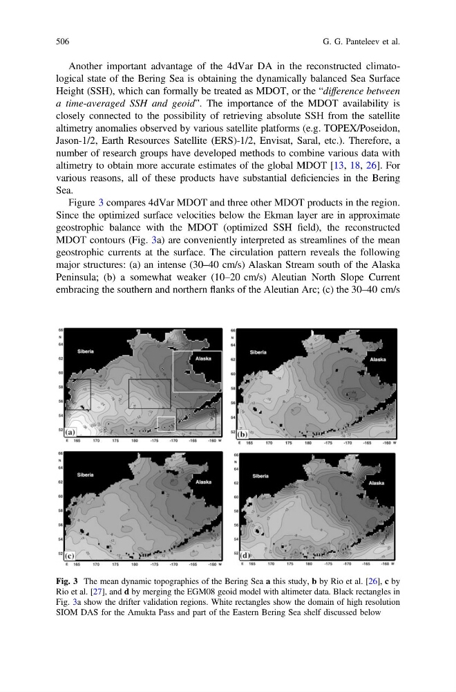
Figure 3 compares 4dVar MDOT and three other MDOT products in the region.
Since the optimized surface velocities below the Ekman layer are in approximate
geostrophic balance with the MDOT (optimized SSH field), the reconstructed
MDOT contours (Fig. 3a) are conveniently interpreted as streamlines of the mean
geostrophic currents at the surface. The circulation pattern reveals the following
major structures: (a) an intense (30–40 cm/s) Alaskan Stream south of the Alaska
Peninsula; (b) a somewhat weaker (10–20 cm/s) Aleutian North Slope Current
embracing the southern and northern flanks of the Aleutian Arc; (c) the 30–40 cm/s
Fig. 3 The mean dynamic topographies of the Bering Sea a this study, b by Rio et al. [26], c by
Rio et al. [27], and d by merging the EGM08 geoid model with altimeter data. Black rectangles in
Fig. 3a show the drifter validation regions. White rectangles show the domain of high resolution
SIOM DAS for the Amukta Pass and part of the Eastern Bering Sea shelf discussed below
506
G. G. Panteleev et al.
Height (SSH), which can formally be treated as MDOT, or the “difference between
a time-averaged SSH and geoid”. The importance of the MDOT availability is
closely connected to the possibility of retrieving absolute SSH from the satellite
altimetry anomalies observed by various satellite platforms (e.g. TOPEX/Poseidon,
Jason-1/2, Earth Resources Satellite (ERS)-1/2, Envisat, Saral, etc.). Therefore, a
number of research groups have developed methods to combine various data with
altimetry to obtain more accurate estimates of the global MDOT [13, 18, 26]. For
various reasons, all of these products have substantial deficiencies in the Bering
Sea.
Figure 3 compares 4dVar MDOT and three other MDOT products in the region.
Since the optimized surface velocities below the Ekman layer are in approximate
geostrophic balance with the MDOT (optimized SSH field), the reconstructed
MDOT contours (Fig. 3a) are conveniently interpreted as streamlines of the mean
geostrophic currents at the surface. The circulation pattern reveals the following
major structures: (a) an intense (30–40 cm/s) Alaskan Stream south of the Alaska
Peninsula; (b) a somewhat weaker (10–20 cm/s) Aleutian North Slope Current
embracing the southern and northern flanks of the Aleutian Arc; (c) the 30–40 cm/s
Fig. 3 The mean dynamic topographies of the Bering Sea a this study, b by Rio et al. [26], c by
Rio et al. [27], and d by merging the EGM08 geoid model with altimeter data. Black rectangles in
Fig. 3a show the drifter validation regions. White rectangles show the domain of high resolution
SIOM DAS for the Amukta Pass and part of the Eastern Bering Sea shelf discussed below
506
G. G. Panteleev et al.