

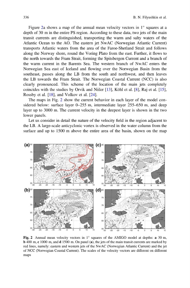
Figure 2a shows a map of the annual mean velocity vectors in 1° squares at a
depth of 30 m in the entire PS region. According to these data, two jets of the main
transit currents are distinguished, transporting the warm and salty waters of the
Atlantic Ocean to the AO. The eastern jet NwAC (Norwegian Atlantic Current)
transports Atlantic waters from the area of the Faroe-Shetland Strait and follows
along the Norway shore, round the Voring Plato from the east. Further, it flows to
the north towards the Fram Strait, forming the Spitsbergen Current and a branch of
the warm current in the Barents Sea. The western branch of NwAC enters the
Norwegian Sea east of Iceland and flowing over the Norwegian Basin from the
southeast, passes along the LB from the south and northwest, and then leaves
the LB towards the Fram Strait. The Norwegian Coastal Current (NCC) is also
clearly pronounced. This scheme of the location of the main jets completely
coincides with the studies by Orvik and Niiler [13], Köhl et al. [8], Raj et al. [15],
Rossby et al. [18], and Volkov et al. [24].
The maps in Fig. 2 show the current behavior in each layer of the model considered below: surface layer 0–255 m, intermediate layer 255–650 m, and deep
layer up to 3000 m. The current velocity in the deepest layer is shown in the two
lower panels.
Let us consider in detail the nature of the velocity field in the region adjacent to
the LB. A large-scale anticyclonic vortex is observed in the water column from the
surface and up to 1500 m above the entire area of the basin, shown on the map
Fig. 2 Annual mean velocity vectors in 1° squares of the AMIGO model at depths: a 30 m,
b 400 m, c 1000 m, and d 1500 m. On panel (a), the jets of the main transit currents are marked by
red lines, namely: eastern and western jets of the NwAC (Norwegian Atlantic Current) and the jet
of NCC (Norwegian Coastal Current). The scales of the velocity vectors are different on different
maps
336
B. N. Filyushkin et al.
depth of 30 m in the entire PS region. According to these data, two jets of the main
transit currents are distinguished, transporting the warm and salty waters of the
Atlantic Ocean to the AO. The eastern jet NwAC (Norwegian Atlantic Current)
transports Atlantic waters from the area of the Faroe-Shetland Strait and follows
along the Norway shore, round the Voring Plato from the east. Further, it flows to
the north towards the Fram Strait, forming the Spitsbergen Current and a branch of
the warm current in the Barents Sea. The western branch of NwAC enters the
Norwegian Sea east of Iceland and flowing over the Norwegian Basin from the
southeast, passes along the LB from the south and northwest, and then leaves
the LB towards the Fram Strait. The Norwegian Coastal Current (NCC) is also
clearly pronounced. This scheme of the location of the main jets completely
coincides with the studies by Orvik and Niiler [13], Köhl et al. [8], Raj et al. [15],
Rossby et al. [18], and Volkov et al. [24].
The maps in Fig. 2 show the current behavior in each layer of the model considered below: surface layer 0–255 m, intermediate layer 255–650 m, and deep
layer up to 3000 m. The current velocity in the deepest layer is shown in the two
lower panels.
Let us consider in detail the nature of the velocity field in the region adjacent to
the LB. A large-scale anticyclonic vortex is observed in the water column from the
surface and up to 1500 m above the entire area of the basin, shown on the map
Fig. 2 Annual mean velocity vectors in 1° squares of the AMIGO model at depths: a 30 m,
b 400 m, c 1000 m, and d 1500 m. On panel (a), the jets of the main transit currents are marked by
red lines, namely: eastern and western jets of the NwAC (Norwegian Atlantic Current) and the jet
of NCC (Norwegian Coastal Current). The scales of the velocity vectors are different on different
maps
336
B. N. Filyushkin et al.