

altimeter data have shown the location of mesoscale long-lived vortices of different
rotation signs that moved along the cyclonic orbit. At specific stages of the motion,
they merged with an anticyclonic vortex located at the center of the deepest part of
the LB (3200 m) at 69° 30′ N, 3° E [15]. Currently, the daily data show that the
previously recorded long-living vortices represented a cluster of separate
short-living eddies, and they better demonstrate the mean eddy drift [16].
The Lofoten Basin is the main reservoir of heat in the Polar seas (PS) [1, 2, 15, 23].
However, the heat content of the central AV is less than the total heat content of the
entire LB waters. This means that warm Atlantic waters should submerge [2, 8] in the
upper layers in the center of the deepest part of the LB, and at the same time, a deep
topographic cyclonic water rotation should exist [5, 14, 15, 22]. In addition, the
deepest part of the LB is located between two frontal zones: in the northwest, the front
is located along the Mona Ridge, and in the southeast, the front is represented by the
Norwegian Current. Physical regularities of water exchange between the North
Atlantic and the Arctic Ocean in 1958–2009 were analyzed on the basis of numerical
experiments with eddy-permitting model of the ocean circulation with a resolution of
0.25° both along the longitude and latitude; they have shown that transversal
oscillations of the Norwegian Current front were responsible for the formation of
intermediate dense waters [11]. In this region, the zone of the vortex formation
moving inside the LB has been noted [14, 15, 17].
A detailed review of the theoretical models by different authors describing the
merging, regeneration, and stability of vortices is given in Bashmachnikov et al. [4].
In the introductory part of this contribution, the annual mean values of temperature, salinity, density, and ocean currents at the sea surface and depths up to
1500 m have been calculated for the whole region of the PS using the Argo model
utilizing the Argo floats observations over the period 2005–2014. These observations showed the existence of the AV over the entire region of the LB with the
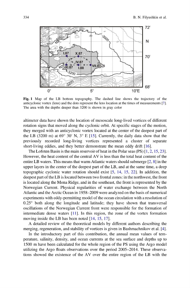
Fig. 1 Map of the LB bottom topography. The dashed line shows the trajectory of the
anticyclonic vortex (lens) and the dots represent the lens location at the times of measurements [7].
The area with the depths deeper than 3200 is shown in gray color
334
B. N. Filyushkin et al.
rotation signs that moved along the cyclonic orbit. At specific stages of the motion,
they merged with an anticyclonic vortex located at the center of the deepest part of
the LB (3200 m) at 69° 30′ N, 3° E [15]. Currently, the daily data show that the
previously recorded long-living vortices represented a cluster of separate
short-living eddies, and they better demonstrate the mean eddy drift [16].
The Lofoten Basin is the main reservoir of heat in the Polar seas (PS) [1, 2, 15, 23].
However, the heat content of the central AV is less than the total heat content of the
entire LB waters. This means that warm Atlantic waters should submerge [2, 8] in the
upper layers in the center of the deepest part of the LB, and at the same time, a deep
topographic cyclonic water rotation should exist [5, 14, 15, 22]. In addition, the
deepest part of the LB is located between two frontal zones: in the northwest, the front
is located along the Mona Ridge, and in the southeast, the front is represented by the
Norwegian Current. Physical regularities of water exchange between the North
Atlantic and the Arctic Ocean in 1958–2009 were analyzed on the basis of numerical
experiments with eddy-permitting model of the ocean circulation with a resolution of
0.25° both along the longitude and latitude; they have shown that transversal
oscillations of the Norwegian Current front were responsible for the formation of
intermediate dense waters [11]. In this region, the zone of the vortex formation
moving inside the LB has been noted [14, 15, 17].
A detailed review of the theoretical models by different authors describing the
merging, regeneration, and stability of vortices is given in Bashmachnikov et al. [4].
In the introductory part of this contribution, the annual mean values of temperature, salinity, density, and ocean currents at the sea surface and depths up to
1500 m have been calculated for the whole region of the PS using the Argo model
utilizing the Argo floats observations over the period 2005–2014. These observations showed the existence of the AV over the entire region of the LB with the
Fig. 1 Map of the LB bottom topography. The dashed line shows the trajectory of the
anticyclonic vortex (lens) and the dots represent the lens location at the times of measurements [7].
The area with the depths deeper than 3200 is shown in gray color
334
B. N. Filyushkin et al.