

and formation of the Mediterranean lenses. During the cruise, 19 moorings were
deployed for a period of 15 days each west of the Strait of Gibraltar to study the
formation of Mediterranean lenses of high salinity. The locations of moorings are
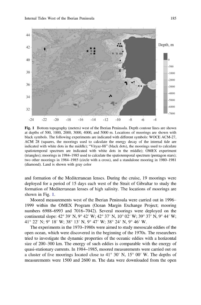
shown in Fig. 1.
Moored measurements west of the Iberian Peninsula were carried out in 1996–
1999 within the OMEX Program (Ocean Margin Exchange Project; mooring
numbers 6988–6993 and 7016–7042). Several moorings were deployed on the
continental slope: 42° 39′ N, 9° 42′ W; 42° 37′ N, 10° 02′ W; 39° 37′ N, 9° 44′ W;
41° 22′ N; 9° 18′ W; 38° 13′ N, 9° 47′ W; 38° 24′ N, 9° 46′ W.
The experiments in the 1970–1980s were aimed to study mesoscale eddies of the
open ocean, which were discovered in the beginning of the 1970s. The researchers
tried to investigate the dynamic properties of the oceanic eddies with a horizontal
size of 200–300 km. The energy of such eddies is comparable with the energy of
quasi-stationary currents. In 1984–1985, moored measurements were carried out on
a cluster of five moorings located close to 41° 30′ N, 15° 00′ W. The depths of
measurements were 1500 and 2600 m. The data were downloaded from the open
Fig. 1 Bottom topography (meters) west of the Iberian Peninsula. Depth contour lines are shown
at depths of 500, 1000, 2000, 3000, 4000, and 5000 m. Locations of moorings are shown with
black symbols. The following experiments are indicated with different symbols: WOCE ACM-27,
ACM 28 (squares, the moorings used to calculate the energy decay of the internal tide are
indicated with white dots in the middle); “Vityaz-88” (black dots), the moorings used to calculate
spatiotemporal spectrum are indicated with white dots in the middle); OMEX experiment
(triangles); moorings in 1984–1985 used to calculate the spatiotemporal spectrum (pentagon stars);
two other moorings in 1984–1985 (circle with a cross), and a standalone mooring in 1980–1981
(diamond). Land is shown with gray color
Internal Tides West of the Iberian Peninsula
185
deployed for a period of 15 days each west of the Strait of Gibraltar to study the
formation of Mediterranean lenses of high salinity. The locations of moorings are
shown in Fig. 1.
Moored measurements west of the Iberian Peninsula were carried out in 1996–
1999 within the OMEX Program (Ocean Margin Exchange Project; mooring
numbers 6988–6993 and 7016–7042). Several moorings were deployed on the
continental slope: 42° 39′ N, 9° 42′ W; 42° 37′ N, 10° 02′ W; 39° 37′ N, 9° 44′ W;
41° 22′ N; 9° 18′ W; 38° 13′ N, 9° 47′ W; 38° 24′ N, 9° 46′ W.
The experiments in the 1970–1980s were aimed to study mesoscale eddies of the
open ocean, which were discovered in the beginning of the 1970s. The researchers
tried to investigate the dynamic properties of the oceanic eddies with a horizontal
size of 200–300 km. The energy of such eddies is comparable with the energy of
quasi-stationary currents. In 1984–1985, moored measurements were carried out on
a cluster of five moorings located close to 41° 30′ N, 15° 00′ W. The depths of
measurements were 1500 and 2600 m. The data were downloaded from the open
Fig. 1 Bottom topography (meters) west of the Iberian Peninsula. Depth contour lines are shown
at depths of 500, 1000, 2000, 3000, 4000, and 5000 m. Locations of moorings are shown with
black symbols. The following experiments are indicated with different symbols: WOCE ACM-27,
ACM 28 (squares, the moorings used to calculate the energy decay of the internal tide are
indicated with white dots in the middle); “Vityaz-88” (black dots), the moorings used to calculate
spatiotemporal spectrum are indicated with white dots in the middle); OMEX experiment
(triangles); moorings in 1984–1985 used to calculate the spatiotemporal spectrum (pentagon stars);
two other moorings in 1984–1985 (circle with a cross), and a standalone mooring in 1980–1981
(diamond). Land is shown with gray color
Internal Tides West of the Iberian Peninsula
185