

350 Nadia Pinardi et al.
LARGESCALE
• MOORED B OY ARRA YS
• VO XOT ANDONDULATINO
INSTRUME TS
• SATElLlTE: EA lEVE l .
SEA URFA ETEMPERATURE.
SEA URFACE SALlNITY.
COLOR. SURFACE WI DS
• DRiFTI 'O DUOYS
(SURFACEA D SUB URF/\CE)
· OlIDERS
• AIRPLAIN E SURVEYS WITU AxaT
MODEL PHYSICS
• PRIMITIVE EQUATION (;lS KM)
• INTERACTIVE OCEA
ATMOSPHERE COUPLING
AT IOSPHERIC FORCI~G
. OPERATIO, AlANALYSES
FROM LARGE SALE MODELS
• ENSEM BlE FORECASTS
OBSERVING
SYSTEM
MODELING
SYSTEM
SHELF SCALE
• REPEATED MUl TI PARAMETRIC
ECTIONS ACROSS SIiElF'
• REMOTE SE SI 'o 1, OEN RAL"
• FERRY SURVEYS OF
SURF ACE PARAMETERS'"
• BUOY STATIO. S
• MESOSCALE SURVEYS
• COASTAL RADAR
• AUTONOMOU UNDERWATER
VEIIIClES
• RIV ER RUNOFF AND lOAD ING
MON ITOR ING
• SED IMENT ANAL Y I
DATA ASS1MlLATION
• OPTIMAL INTERPOLATION
ANDIOR IV\L\IAN FILTER
• ADJOINT MODELS
ECOSYSTUI MODELS
• PELAGIC COMPARTMENT
• DENTHIC·PELAOIC COU PLI 'G
• SEDIMENT DYNAMICS
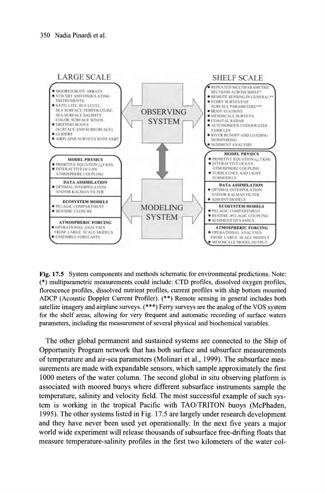
Fig. 17.5 System components and methods schematic for environmental predictions. Note:
(*) multiparametric measurements could include: CTD profiles, dissolved oxygen profiles,
florescence profiles, dissolved nutrient profiles, current profiles with ship bouom mounted
ADCP (Acoustic Doppler Current Profiler). (**) Remote sens ing in general includes both
satellite imagery and airplane surveys. (***) Ferry surveys are the analog ofthe VOS system
for the shelf areas, allowing for very frequent and automatic recording of surface waters
parameters, including the measurement of several physical and biochemical variables.
The other global pennanent and sustained systems are connected to the Ship of
Opportunity Program network that has both surface and subsurface measurements
of temperature and air-sea parameters (Molinari et al., 1999). The sub surf ace measurements are made with expandable sensors, which sample approximately the first
1000 meters of the water column. The second global in situ observing platfonn is
associated with moored buoys where different subsurface instruments sample the
temperature, salinity and velocity field. The most successful example of such system is working in the tropical Pacific with TAO/TRITON buoys (McPhaden,
1995). The other systems listed in Fig. 17.5 are large1y under research development
and they have never been used yet operationally. In the next five years a major
world wide experiment will release thousands of subsurface free-drifting floats that
measure temperature-salinity profiles in the first two kilometers of the water col-
LARGESCALE
• MOORED B OY ARRA YS
• VO XOT ANDONDULATINO
INSTRUME TS
• SATElLlTE: EA lEVE l .
SEA URFA ETEMPERATURE.
SEA URFACE SALlNITY.
COLOR. SURFACE WI DS
• DRiFTI 'O DUOYS
(SURFACEA D SUB URF/\CE)
· OlIDERS
• AIRPLAIN E SURVEYS WITU AxaT
MODEL PHYSICS
• PRIMITIVE EQUATION (;lS KM)
• INTERACTIVE OCEA
ATMOSPHERE COUPLING
AT IOSPHERIC FORCI~G
. OPERATIO, AlANALYSES
FROM LARGE SALE MODELS
• ENSEM BlE FORECASTS
OBSERVING
SYSTEM
MODELING
SYSTEM
SHELF SCALE
• REPEATED MUl TI PARAMETRIC
ECTIONS ACROSS SIiElF'
• REMOTE SE SI 'o 1, OEN RAL"
• FERRY SURVEYS OF
SURF ACE PARAMETERS'"
• BUOY STATIO. S
• MESOSCALE SURVEYS
• COASTAL RADAR
• AUTONOMOU UNDERWATER
VEIIIClES
• RIV ER RUNOFF AND lOAD ING
MON ITOR ING
• SED IMENT ANAL Y I
DATA ASS1MlLATION
• OPTIMAL INTERPOLATION
ANDIOR IV\L\IAN FILTER
• ADJOINT MODELS
ECOSYSTUI MODELS
• PELAGIC COMPARTMENT
• DENTHIC·PELAOIC COU PLI 'G
• SEDIMENT DYNAMICS
Fig. 17.5 System components and methods schematic for environmental predictions. Note:
(*) multiparametric measurements could include: CTD profiles, dissolved oxygen profiles,
florescence profiles, dissolved nutrient profiles, current profiles with ship bouom mounted
ADCP (Acoustic Doppler Current Profiler). (**) Remote sens ing in general includes both
satellite imagery and airplane surveys. (***) Ferry surveys are the analog ofthe VOS system
for the shelf areas, allowing for very frequent and automatic recording of surface waters
parameters, including the measurement of several physical and biochemical variables.
The other global pennanent and sustained systems are connected to the Ship of
Opportunity Program network that has both surface and subsurface measurements
of temperature and air-sea parameters (Molinari et al., 1999). The sub surf ace measurements are made with expandable sensors, which sample approximately the first
1000 meters of the water column. The second global in situ observing platfonn is
associated with moored buoys where different subsurface instruments sample the
temperature, salinity and velocity field. The most successful example of such system is working in the tropical Pacific with TAO/TRITON buoys (McPhaden,
1995). The other systems listed in Fig. 17.5 are large1y under research development
and they have never been used yet operationally. In the next five years a major
world wide experiment will release thousands of subsurface free-drifting floats that
measure temperature-salinity profiles in the first two kilometers of the water col-