

Forecasting of Sea-level, Currents and Sea Ice in the Baltic Sea
233
ECMWF
IURLAM
MESAN
Global
Limi led area f--------.
Meso-scale
alm ospheric
almospheric
analysis
model
model
model
/
/
~
V
/
BOBA
HIROMB
HYPNE
Local ocean
Sea ice model
/
3D baroclinic
Nesled wave
models
ocean model
model
7
I·~
~
t
-- ~~~
HBV
MATCH
4 Hydrologi cal
---to
Almospheric
Drift models
Ecological
chemical
models
runoff model
transport model
I
t
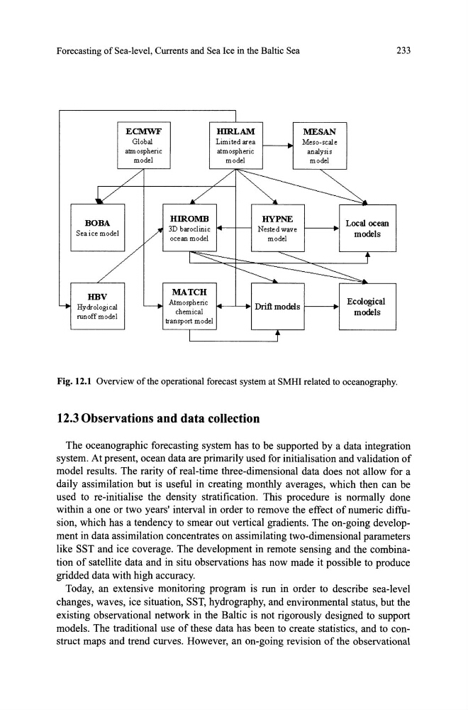
Fig. 12.1 Overview ofthe operational forecast system at SMHI related to oceanography.
12.30bservations and data collection
The oceanographic forecasting system has to be supported by a data integration
system. At present, ocean data are primarily used for initialisation and validation of
model results. The rarity of real-time three-dimensional data does not allow for a
daily assimilation but is useful in creating monthly averages, which then can be
used to re-initialise the density stratification. This procedure is normally done
within a one or two years' interval in order to remove the effect of numeric diffusion, which has a tendency to smear out vertical gradients. The on-going development in data assimilation concentrates on assimilating two-dimensional parameters
like SST and ice coverage. The development in remote sensing and the combination of satellite data and in situ observations has now made it possible to produce
gridded data with high accuracy.
Today, an extensive monitoring program is run in order to describe sea-level
changes, waves, ice situation, SST, hydrography, and environmental status, but the
existing observational network in the Baltic is not rigorously designed to support
models. The traditional use of these data has been to create statistics, and to construct maps and trend curves. However, an on-going revision of the observational
233
ECMWF
IURLAM
MESAN
Global
Limi led area f--------.
Meso-scale
alm ospheric
almospheric
analysis
model
model
model
/
/
~
V
/
BOBA
HIROMB
HYPNE
Local ocean
Sea ice model
/
3D baroclinic
Nesled wave
models
ocean model
model
7
I·~
~
t
-- ~~~
HBV
MATCH
4 Hydrologi cal
---to
Almospheric
Drift models
Ecological
chemical
models
runoff model
transport model
I
t
Fig. 12.1 Overview ofthe operational forecast system at SMHI related to oceanography.
12.30bservations and data collection
The oceanographic forecasting system has to be supported by a data integration
system. At present, ocean data are primarily used for initialisation and validation of
model results. The rarity of real-time three-dimensional data does not allow for a
daily assimilation but is useful in creating monthly averages, which then can be
used to re-initialise the density stratification. This procedure is normally done
within a one or two years' interval in order to remove the effect of numeric diffusion, which has a tendency to smear out vertical gradients. The on-going development in data assimilation concentrates on assimilating two-dimensional parameters
like SST and ice coverage. The development in remote sensing and the combination of satellite data and in situ observations has now made it possible to produce
gridded data with high accuracy.
Today, an extensive monitoring program is run in order to describe sea-level
changes, waves, ice situation, SST, hydrography, and environmental status, but the
existing observational network in the Baltic is not rigorously designed to support
models. The traditional use of these data has been to create statistics, and to construct maps and trend curves. However, an on-going revision of the observational